

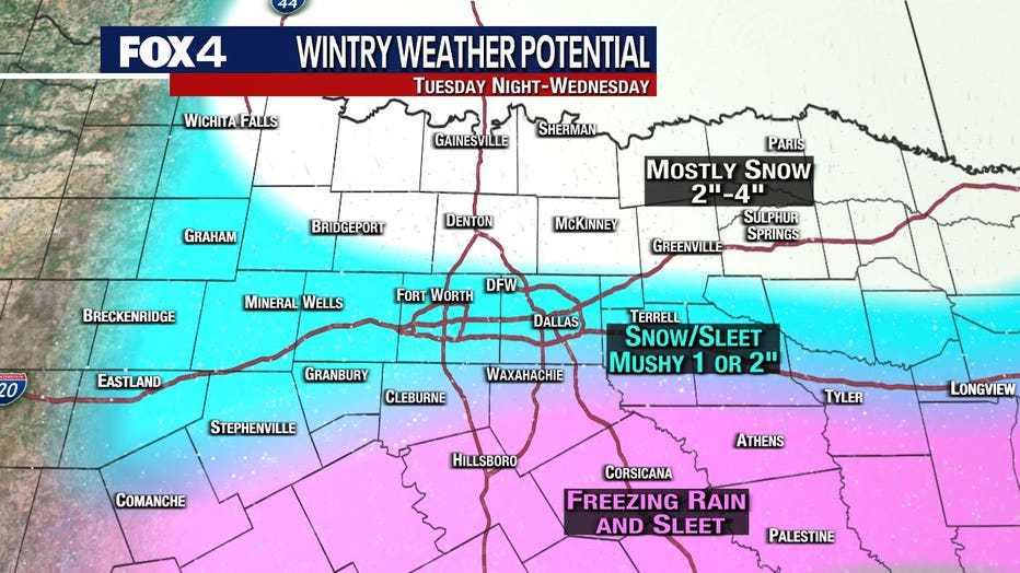
More snow, sleet, ice expected Tuesday night, Wednesday across North Texas

DALLAS - A Winter Storm Warning goes into effect at 6 p.m. Tuesday and will last for 36 hours as another round of snow and ice is forecasted to hit North Texas.
Accumulations of several inches are possible for parts of the region, which is still covered in snowfall from Sunday night and Monday.
There’s a chance of snow starting Tuesday evening, then snow with possible sleet and freezing rain likely after midnight. There could be about an inch of snow and sleet accumulation. There’s also the potential of slight ice accumulation.
Lows should be in the upper teens with slight winds of 5 to 10 mph overnight.
North Texans will wake up Wednesday morning to cloudy skies and more snow, with a slight chance of freezing rain in the morning and a slight chance of snow in the afternoon.
Accumulations will vary across the region, with heaviest totals north of 380.
Highs will be in the lower 20s on Wednesday, with northeast winds 5 to 10 mph.
Thursday will see the area slightly warmer, but still below freezing with cloudy to partly sunny skies. Expected highs will be in the upper 20s, but win chills could be as low as five degrees.
Friday is when North Texas will climb above freezing for the first time in almost a week, with expected highs in the low 30s.
RELATED:
North Texans try to cope as outages last for hours due to winter weather
Hundreds of thousands without power for second day across North Texas as blackouts continue