

Dallas weather: Rain, storms across North Texas Saturday

Dallas weather: April 20 morning forecast
It will be a rainy Saturday across North Texas. FOX 4 meteorologist Kylie Capps takes a look at what to expect in your forecast.
This Saturday was to be a rainy one.
A severe thunderstorm warning was issued for Collin, Cooke, Denton and Grayson County until 7:00 a.m., but that has since expired as storms have weakened.
Some areas saw quarter-sized hail. Pocket-change sized hail is possible for some of the strongest storms.
Lightning and heavy rain will be the main threats as this first batch of showers and storms moves through.

Ennis Bluebonnet Festival, Fort Worth Main Street Arts Festival canceled Saturday due to weather
The Ennis Bluebonnet Festival was called off on Saturday afternoon due to rain and storms.
There will be a batch of rain in the morning, but we should get some relief later in the day.
Expect lower rain coverage in the late morning to early afternoon hours.
A second batch of storms is expected to arrive in the mid-afternoon and should bring more heavy rain.
"It's an indoor day for sure," said FOX 4 meteorologist Kylie Capps.

On Saturday night we will see chilly rain on and off.
Some areas have already seen 2 to 3 inches of rain and 1 to 2 inches more could fall today.
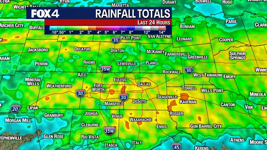
The heaviest totals are expected to be in the east and southeast.
The temperatures will start in the 50s on Saturday morning and stay in the 50s throughout the day.
The high is only expected to reach 59 degrees.
The rain should be out of the area by the time the sun rises on Sunday morning.
Clouds should break up by Sunday afternoon.
Rain Totals
Live Weather Radar - North Texas

7-Day Forecast

Temperatures will climb back to the 80s by the early parts of next week.
There are shots at rain and storms on Wednesday and Thursday.