

Dallas Weather: Winter Storm Warning issued; 5 inches of snow and sleet possible in North Texas
DALLAS - Do you have everything you need before you are snowed in? A major winter storm is officially approaching, and it is crucial to finalize your preparations now. Wintry precipitation is expected to impact all of North Texas from Friday night through Monday, with sleet, snow, and freezing rain likely to create dangerous ice across the region.
Texas Winter Storm Warning

The National Weather Service has issued a Winter Storm Warning for North and Central Texas, effective from 6 p.m. Friday through noon Sunday. Additionally, an Extreme Cold Warning will be in effect from Saturday evening through Monday morning.
An Ice Storm Warning is now in effect through Sunday at noon for parts of North Texas, including Anderson, Freestone, Henderson, and Van Zandt counties.
FOX 4 forecasters warn that North Texas may not climb back above freezing until Monday afternoon, which means travel could remain hazardous through Monday evening. According to the NWS, a full changeover to sleet and snow is expected across parts of North Texas late Saturday before the wintry weather ends Sunday. Localized power outages are possible due to ice accumulating on trees and power lines.
If you lose power, you can still stream FOX LOCAL on our mobile app: DOWNLOAD HERE
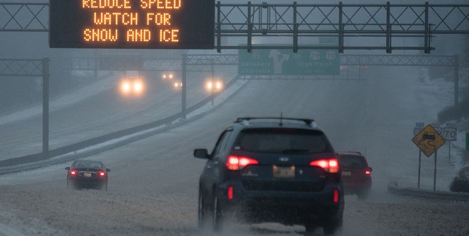
Dallas weather Friday forecast

Dallas weather: Jan. 23 evening forecast
The wintry mix is nearly here in North Texas. Get the latest from FOX 4 chief meteorologist Dan Henry on the winter storm arriving in DFW in this Jan. 23 evening forecast.
Light rain began in parts of the Metroplex on Friday morning. Showers were expected to continue through the day, with coverage and intensity increasing in the afternoon. Temperatures remained in the 40s for most of the day before the arctic air settles in tonight. As temperatures drop below freezing overnight, liquid precipitation will transition to a frozen mix. Freezing rain and sleet are expected to begin as early as 9 p.m. for counties north and west of the Metroplex and around midnight for the DFW area.
Read More:
- LIVE UPDATES: Winter Storm Warning in effect; North Texas braces for record cold
- Dallas weather: Tracking school cancellations, early dismissals
- Dallas weather: DFW Airport leads nation in flight cancellations ahead of major winter storm
Timing the storm: When will it start snowing?

While the forecast remains subject to change, current data suggests a transition from cold rain to a wintry mix beginning Friday evening.
North of DFW (Sherman, Paris, Graham): Rain and ice are expected Friday night, transitioning to sleet and snow on Saturday. Freezing rain and sleet are expected to begin accumulating around 6 p.m. Friday.
DFW Metroplex: Rain is forecast to transition into freezing rain after midnight Friday. The most significant impacts appear to start around noon Saturday. Expect periods of freezing rain and sleet Saturday morning and afternoon, with heavy sleet possible Saturday night. The system should end as snow Sunday morning.
South of DFW (Waco, Palestine, Killeen): Rain is expected Friday night into early Saturday. A wintry mix will likely arrive during the day on Saturday, though timing and totals may vary.
Ice and snow totals expected in Dallas
Ice accumulation from freezing rain is expected Friday night through Saturday. Following the freezing rain, the system will transition to sleet and snow. The DFW area is currently expecting 0.25 to 0.5 inches of pure ice.
Multiple inches of sleet and snow are also forecast. For areas north of Interstate 20, 2 to 5 inches of sleet and snow are expected on top of the initial ice layer. Slightly higher totals may impact eastern parts of North Texas. Officials warn it is crucial to stay off the roads as ice will coat trees, power lines, and roadways.
Extreme Cold Warning: Life-threatening cold expected

An Extreme Cold Warning is in place as arctic air brings life-threatening conditions to the region. Single-digit low temperatures will sweep the area, with wind chills expected to reach -4 to -12 degrees Sunday night.
Officials advise everyone to stay indoors or ensure all skin is covered if you must go outside. It is also crucial to ensure the safe use of heaters and generators, check carbon monoxide detectors, and have emergency kits ready.
Record-breaking cold possible in Dallas

While the ice and snow are the most visible threats, the sheer intensity of the arctic air could make history. Forecasters at the National Weather Service warn that North Texas could approach record low temperatures on Sunday and Monday.
Will there be power outages in North Texas?

ERCOT expects stable power grid ahead of 2026 winter storm
ERCOT says power outages may occur during the 2026 winter storm in North Texas, but they expect it to be stable unlike what happened in 2021. FOX 4's Shaun Rabb has more.
Gov. Greg Abbott on Thursday issued a disaster declaration for 134 counties ahead of the weekend weather. This is expected to be the most significant winter storm since February 2021; however, state officials and the Electric Reliability Council of Texas (ERCOT) say significant upgrades have been made to the grid since then.
ERCOT President Pablo Vegas stated there will be more than enough power to meet demand, noting that this storm is expected to be more "transient" than the 2021 event. "We have well over 90,000 megawatts of capacity to be able to serve demand," Vegas said. "We’re not anticipating any shortfalls in power."
While the state is confident in the grid's stability, localized outages remain a risk. Freezing rain is the primary threat to infrastructure, as ice can weigh down power lines and tree limbs, causing them to snap.
We want to see your winter weather photos! You can share your snow and ice pictures with us below.
How to Prepare for the Winter Storm

Dallas Winter Storm: Shoppers clear out grocery stores
If you waited until the last minute to stock your pantry ahead of the major winter storm, prepare for a busy trip to the grocery store. FOX 4's Payton May is inside Walmart with a look at the sold-out items across Texas.
With temperatures likely dropping below 10 degrees Saturday and Sunday nights, your plumbing is at high risk. Follow these steps immediately:
- Insulate Pipes: Wrap exposed pipes in attics, crawl spaces, and on outside walls.
- Disconnect Hoses: Remove garden hoses and drain outdoor lines.
- Drip Faucets: A slow drip from faucets near exterior walls can prevent pressure buildup and pipe bursts.
- Open Cabinets: Keep kitchen and bathroom cabinet doors open to allow warm air to reach pipes.
- Maintain Heat: Keep your thermostat at a consistent temperature; never set it lower than 55 degrees.
Winter weather checklist

North Texas medical workers prep for busy winter storm weekend
With icy roads and potential hypothermia on the horizon, North Texas EMS workers are prepared to work overtime to keep residents safe. FOX 4's Casey Stegall has more.
The NWS recommends completing all preparations before the front arrives:
- Stock at least three days of nonperishable food, water, and medications.
- Bring all pets indoors.
- Gather flashlights, batteries, and blankets.
- Fill vehicle gas tanks and check emergency kits.
Difference between winter storm watch and warning
A Warning means the storm is imminent or already occurring. When a Warning is issued, it is time to take immediate action and stay off the roads.
A Winter Storm Watch is issued 24 to 72 hours before an event when significant wintry weather is possible but the exact timing is still uncertain.
Featured
Dallas weather: What is a Winter Storm Watch?
As an arctic front moves toward North Texas, the National Weather Service (NWS) has issued a Winter Storm Watch for the region. Many viewers have reached out to ask exactly what that means and how it differs from a warning.
School Closings
It remains unclear if North Texas schools will close early next week, as most districts wait for the front to arrive before making a final decision. However, many districts have already announced changes to school schedules and athletic events across the DFW Metroplex.
FULL LIST OF CANCELED ACTIVITIES IN NORTH TEXAS
Dallas weather forecast recap

Sleet is expected to be the predominant form of precipitation this weekend, though freezing rain and snow will also occur. Current projections for DFW include 0.25-0.50 inches of ice and 1-2 inches of sleet/snow.
Once temperatures drop below freezing, they are expected to stay there for 60 to 72 hours. Single-digit lows and wind chills as low as -10° are possible before the region finally climbs back above 32° on Tuesday afternoon.
LIVE RADAR: Dallas-Fort Worth

The Source: Information in this article comes from the National Weather Service, FOX 4 meteorologists, ERCOT, Texas officials and previous reporting.