

One More Nice Day!
Enjoy the mild conditions for the rest of the weekend. On Monday, the next cold front brings a rain and very cold air back to North Texas. Expect hard freezes Tuesday and Wednesday morning, with temperatures staying well below normal through the week.
Enjoy the mild conditions for the rest of the weekend. On Monday, the next cold front brings a rain and very cold air back to North Texas. Expect hard freezes Tuesday and Wednesday morning, with temperatures staying well below normal through the week.
Quick Warmup
If you have any yard work to do, this will be a great weekend for it. The sun sticks around, temperatures warm back up. We're talking 60s and 70s, before the bottom falls out once again on Monday. Cold rain will accompany a front Monday that will send our temperatures from the low 60s in the morning straight into the 40s and 30s by the late afternoon. Blustery north wind will make matters worse. Also, Tuesday and Wednesday morning lows will be in the mid-20s...time to winterize those boats!
If you have any yard work to do, this will be a great weekend for it. The sun sticks around, temperatures warm back up. We're talking 60s and 70s, before the bottom falls out once again on Monday. Cold rain will accompany a front Monday that will send our temperatures from the low 60s in the morning straight into the 40s and 30s by the late afternoon. Blustery north wind will make matters worse. Also, Tuesday and Wednesday morning lows will be in the mid-20s...time to winterize those boats!
Chilly Friday Morning!
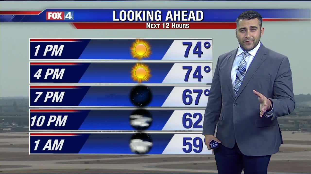
Temperatures are in the 30s and 40s this morning, with wind chills in the 30s! Clouds will hold temps in the 40s through about midday before we start to clear out. High temperatures will climb into the low 50s by the afternoon. The weekend starts out chilly, but a warming trend is expected through Sunday afternoon. Then big changes, again, by Monday...
Temperatures are in the 30s and 40s this morning, with wind chills in the 30s! Clouds will hold temps in the 40s through about midday before we start to clear out. High temperatures will climb into the low 50s by the afternoon. The weekend starts out chilly, but a warming trend is expected through Sunday afternoon. Then big changes, again, by Monday...
Weekend Warmup
As we dry out our temperatures will begin their steady climb back into the 60s and 70s for the weekend, but Monday looks pack another cold punch with plunging temperatures and more rain. #fox4weather
As we dry out our temperatures will begin their steady climb back into the 60s and 70s for the weekend, but Monday looks pack another cold punch with plunging temperatures and more rain. #fox4weather
The Chill Has Moved In
We will continue to see the rain taper off the rest of the afternoon, but the breezy chill remains. Temperatures as we head into Friday will be well be average with many of barely seeing the 50s by Friday afternoon. Temperatures moderate some this weekend before temperatures take another sharp plunge on Monday.
We will continue to see the rain taper off the rest of the afternoon, but the breezy chill remains. Temperatures as we head into Friday will be well be average with many of barely seeing the 50s by Friday afternoon. Temperatures moderate some this weekend before temperatures take another sharp plunge on Monday.

Dress For The Drive Home!
Cold air is filtering in this morning! Scattered showers will stick around this morning but taper off by this afternoon. We stay above freezing, but wind chill values will likely hover in the low and mid 30s today. Dry air moves in as we close out the work week...and sunshine returns!
Cold air is filtering in this morning! Scattered showers will stick around this morning but taper off by this afternoon. We stay above freezing, but wind chill values will likely hover in the low and mid 30s today. Dry air moves in as we close out the work week...and sunshine returns!

Wet AM Commute
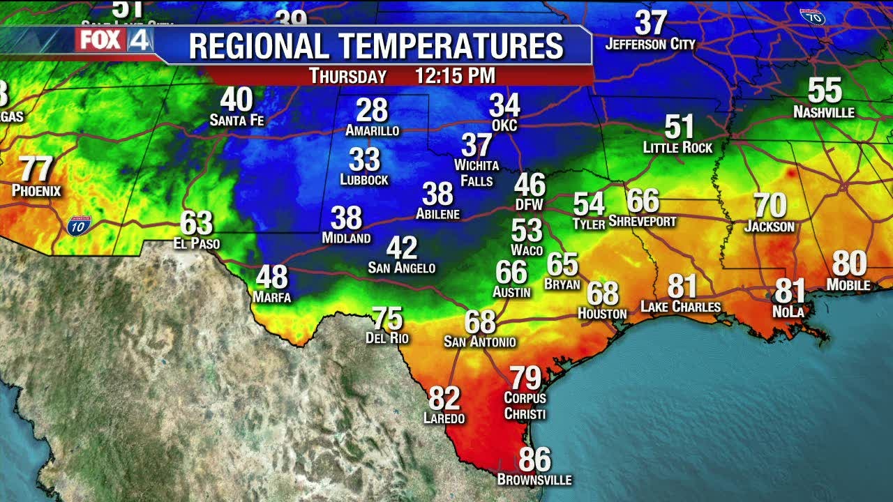
Showers and thunderstorms will dampen the morning commute across DFW with "mild" temps, but don't let the morning temps fool you. Strong cold front will allow the bottom to fall out leaving us with temperatures into the 40s for a good portion of Thursday. That's not the worst part, wind will pick up dramatically leaving us with wind chill values in the 30s for DFW and 20s for the areas NW of the metro.
Showers and thunderstorms will dampen the morning commute across DFW with "mild" temps, but don't let the morning temps fool you. Strong cold front will allow the bottom to fall out leaving us with temperatures into the 40s for a good portion of Thursday. That's not the worst part, wind will pick up dramatically leaving us with wind chill values in the 30s for DFW and 20s for the areas NW of the metro.
Wet Morning Commute
Showers and thunderstorms will dampen the morning commute across DFW with "mild" temps, but don't let the morning temps fool you. Strong cold front will allow the bottom to fall out leaving us with temperatures into the 40s for a good portion of Thursday. That's not the worst part, wind will pick up dramatically leaving us with wind chill values in the 30s for DFW and 20s for the areas NW of the metro.
Showers and thunderstorms will dampen the morning commute across DFW with "mild" temps, but don't let the morning temps fool you. Strong cold front will allow the bottom to fall out leaving us with temperatures into the 40s for a good portion of Thursday. That's not the worst part, wind will pick up dramatically leaving us with wind chill values in the 30s for DFW and 20s for the areas NW of the metro.

Wednesday Afternoon Update
Not much has changed regarding the short-term forecast. Be ready for that cold front tomorrow!
Not much has changed regarding the short-term forecast. Be ready for that cold front tomorrow!

Wednesday Forecast
After a wet and cool Tuesday, today will feature slightly drier conditions. We stay cloudy all day, with high temps topping out in the low 70s. Showers and storms increase in coverage overnight thanks to a strong cold front. We fall into the 40s by lunchtime tomorrow, with most shower activity drying out.
After a wet and cool Tuesday, today will feature slightly drier conditions. We stay cloudy all day, with high temps topping out in the low 70s. Showers and storms increase in coverage overnight thanks to a strong cold front. We fall into the 40s by lunchtime tomorrow, with most shower activity drying out.
Chilly & Wet Weather Returns!
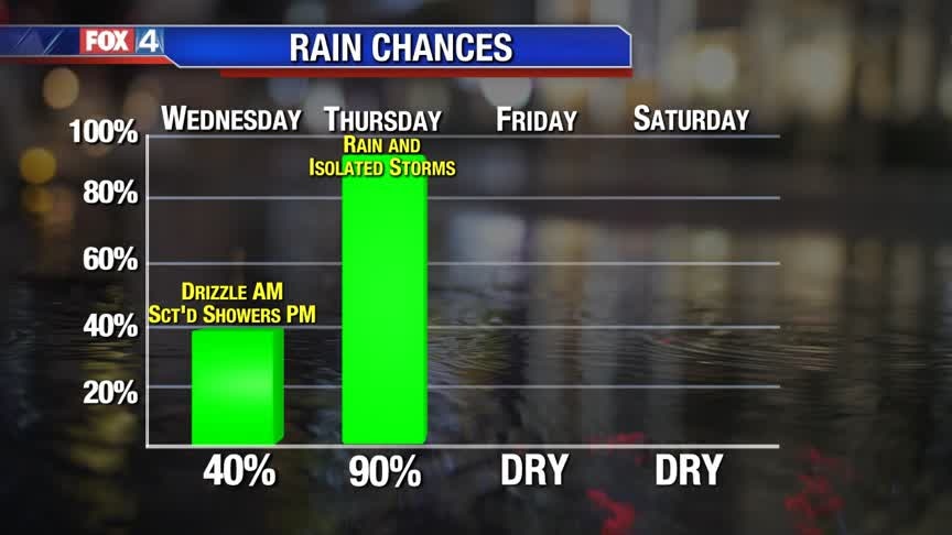
Low clouds and drizzle continue tonight for parts of North Texas. Expect a gloomy start to Wednesday, with scattered showers by the afternoon. Widespread rain and some storms move through Thursday, with the next cold front. Another shot of chilly air moves in behind the front to end the work week.
Low clouds and drizzle continue tonight for parts of North Texas. Expect a gloomy start to Wednesday, with scattered showers by the afternoon. Widespread rain and some storms move through Thursday, with the next cold front. Another shot of chilly air moves in behind the front to end the work week.
Murky Tuesday
Low clouds, mist, drizzle, and fog continues for most of the area making many North Texans want to snuggle up on the couch and watch Fox 4. Light rain should pick up a little late tonight, but really ramp up Wednesday night for our northwestern areas and Thursday for all of North Texas. Temperatures will be tumbling throughout the day on Thursday with highs in the 50s for Friday. Another shot of cold air looks to work it's way into North Texas late Sunday night/Monday morning.
Low clouds, mist, drizzle, and fog continues for most of the area making many North Texans want to snuggle up on the couch and watch Fox 4. Light rain should pick up a little late tonight, but really ramp up Wednesday night for our northwestern areas and Thursday for all of North Texas. Temperatures will be tumbling throughout the day on Thursday with highs in the 50s for Friday. Another shot of cold air looks to work it's way into North Texas late Sunday night/Monday morning.
Rain & Chilly Temperatures Return!
A weak front moves through North Texas Tuesday returning clouds and some sprinkles. Rain chances begin increasing late Wednesday ahead of a stronger cold front. Widespread rain, heavy at times, moves through Thursday. behind the front. expect another shot of cooler air to end the week.
A weak front moves through North Texas Tuesday returning clouds and some sprinkles. Rain chances begin increasing late Wednesday ahead of a stronger cold front. Widespread rain, heavy at times, moves through Thursday. behind the front. expect another shot of cooler air to end the week.
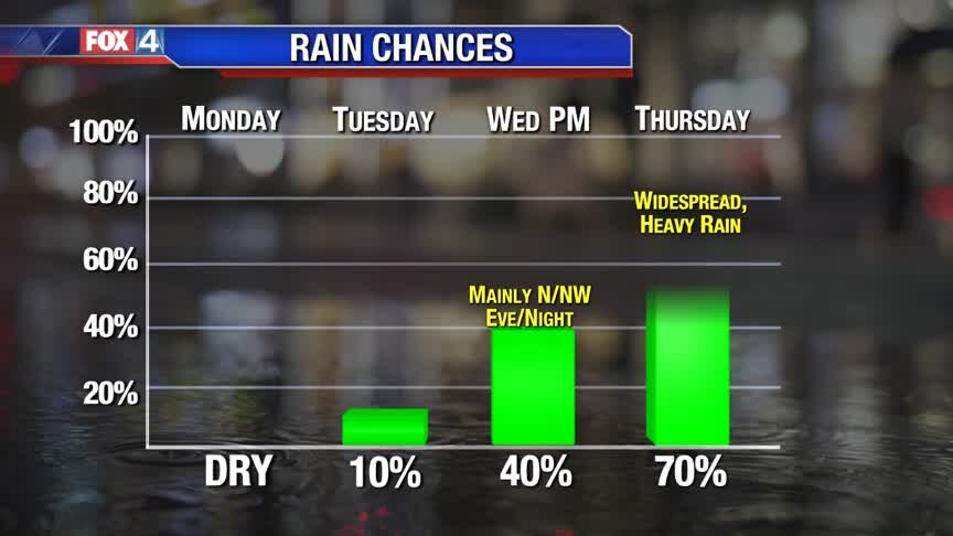
Mild Monday
Temperatures this afternoon will briefly climb to above average which isn't a bad thing. Temperatures will remain pleasant through Wednesday, but a strong cold front Thursday morning will bring North Texas well below the norm through the weekend. This cold front will also bring some promising rain to the area as well as a rumble of thunder. Heaviest of rain looks to fall across the northwestern counties. We will keep an eye on the flooding potential as newer data becomes available in the next few days.
Temperatures this afternoon will briefly climb to above average which isn't a bad thing. Temperatures will remain pleasant through Wednesday, but a strong cold front Thursday morning will bring North Texas well below the norm through the weekend. This cold front will also bring some promising rain to the area as well as a rumble of thunder. Heaviest of rain looks to fall across the northwestern counties. We will keep an eye on the flooding potential as newer data becomes available in the next few days.
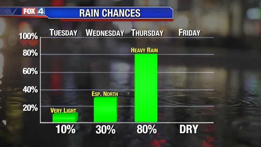
Tracking The Next Cold Front!
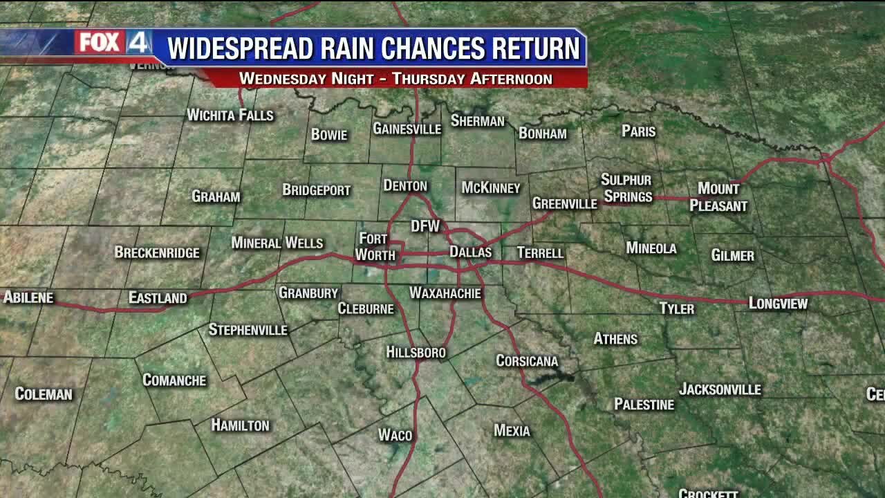
Clouds and mild temperatures are on tap to start the work week. Rain chances slowly creep up as the next cold front approaches Wednesday night. By Thursday, expect widespread rain and much cooler temperatures. Another shot of colder air moves in behind the front to start the weekend.
Clouds and mild temperatures are on tap to start the work week. Rain chances slowly creep up as the next cold front approaches Wednesday night. By Thursday, expect widespread rain and much cooler temperatures. Another shot of colder air moves in behind the front to start the weekend.

Tracking The Next Cold Front!
Clouds and mild temperatures are on tap to start the work week. Rain chances slowly creep up as the next cold front approaches Wednesday night. By Thursday, expect widespread rain and much cooler temperatures. Another shot of colder air moves in behind the front to start the weekend.
Clouds and mild temperatures are on tap to start the work week. Rain chances slowly creep up as the next cold front approaches Wednesday night. By Thursday, expect widespread rain and much cooler temperatures. Another shot of colder air moves in behind the front to start the weekend.
A Beautiful Sunday!
Patio weather today! Get outside and enjoy the sunshine and the 60s/70s this afternoon. Big changes arrive once again by midweek.
Patio weather today! Get outside and enjoy the sunshine and the 60s/70s this afternoon. Big changes arrive once again by midweek.
Slow Warming Trend
High pressure remains in control keeping sunshine in place to end the weekend. After a chilly start to the day, southerly winds help warm us back into the 60s. Milder temperatures continue into next weekend ahead of another storm system. A cold front brings widespread rain by Thursday. Another shot of cold air moves in behind the front to end the week.
High pressure remains in control keeping sunshine in place to end the weekend. After a chilly start to the day, southerly winds help warm us back into the 60s. Milder temperatures continue into next weekend ahead of another storm system. A cold front brings widespread rain by Thursday. Another shot of cold air moves in behind the front to end the week.
Bundle Up!
Happy Saturday! We start off chilly, with temps in the 30s for most this morning. We'll warm into the upper 50s and low 60s, with plentiful sunshine!
Happy Saturday! We start off chilly, with temps in the 30s for most this morning. We'll warm into the upper 50s and low 60s, with plentiful sunshine!