


April 8 afternoon forecast
Dan Henry has the latest forecast.
Dan Henry has the latest forecast.

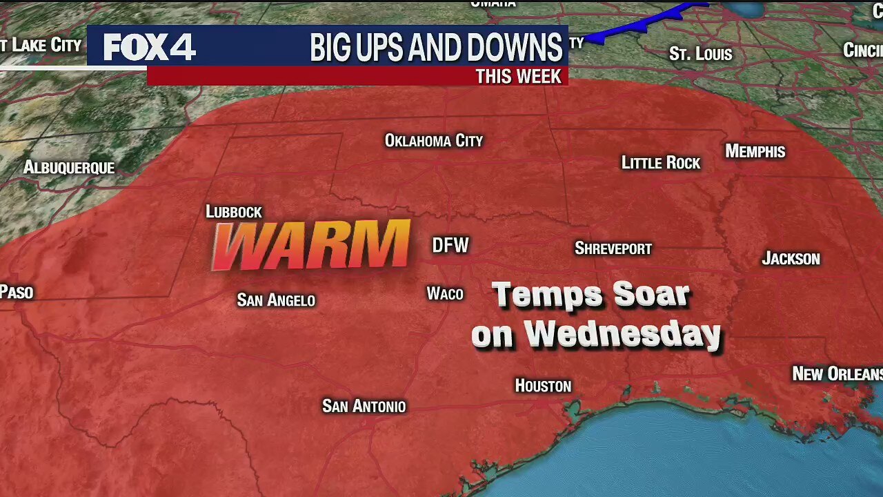
HOT... then NOT!
Get ready for near record heat today as the air dries out by noon and reaches the low 90s. Then we'll cooling down back to the low 70s on Thursday.
Get ready for near record heat today as the air dries out by noon and reaches the low 90s. Then we'll cooling down back to the low 70s on Thursday.
April 7 overnight forecast
Dan Henry has the latest forecast.
Dan Henry has the latest forecast.
Tuesday Afternoon Weather Update
Dan Henry has the latest forecast.
Dan Henry has the latest forecast.

Quick shot 'o' SPRING!
After a cloudy and muggy start, the clouds will break a bit Tuesday and allow the temperatures to get up into he 80s by the afternoon.
After a cloudy and muggy start, the clouds will break a bit Tuesday and allow the temperatures to get up into he 80s by the afternoon.
Warm up continues
Highs will be in the mid 80s on Tuesday and could hit 90 on Wednesday.
Highs will be in the mid 80s on Tuesday and could hit 90 on Wednesday.

Warmer week (at least to start!)
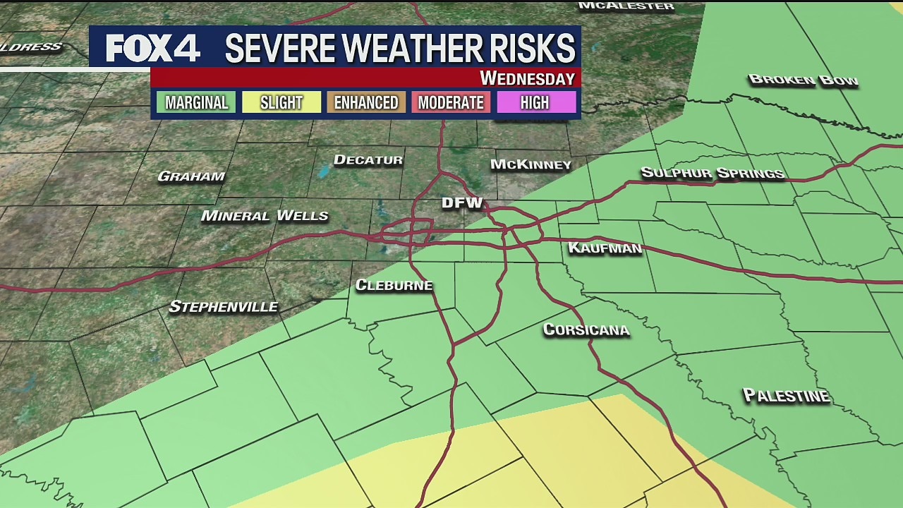
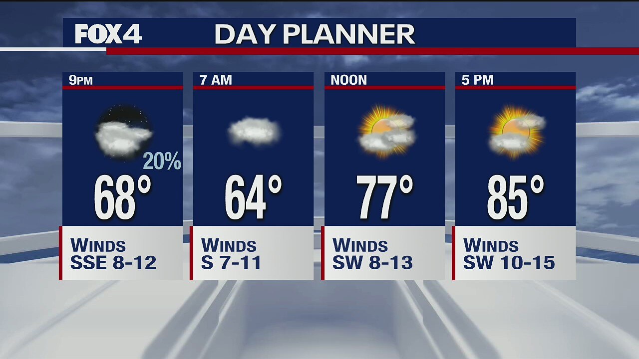
Still a lot of clouds today. Some showers but just scattered. Highs in 70s. Very warm Tue-Wed, well into 80s! Showers/storms Wed night-Thu, turning MUCH cooler to finish week. Could be unsettled again.
Still a lot of clouds today. Some showers but just scattered. Highs in 70s. Very warm Tue-Wed, well into 80s! Showers/storms Wed night-Thu, turning MUCH cooler to finish week. Could be unsettled again.

Temperatures on the way up, and rain chances this week
Ali Turiano has your latest forecast for North Texas.
Ali Turiano has your latest forecast for North Texas.

Small chance of rain Sunday
Sunday will be much warmer than Saturday, with the warm up continuing for the next few days.
Sunday will be much warmer than Saturday, with the warm up continuing for the next few days.

Monday Midday Update
Here's an update on shower/storm chances this afternoon/evening.
Here's an update on shower/storm chances this afternoon/evening.

Monday Morning Forecast
Widespread showers and storms return to the forecast today!
Widespread showers and storms return to the forecast today!

Strong Storms Possible!
The next disturbance brings widespread rain and some strong storms Monday. Gusty winds and hail will be possible. We briefly dry out mid-week, but another storm system returns storm chances Thursday into Friday.
The next disturbance brings widespread rain and some strong storms Monday. Gusty winds and hail will be possible. We briefly dry out mid-week, but another storm system returns storm chances Thursday into Friday.

A Nice Sunday!
After a sunny and seasonably cool start to the day, clouds increase through the afternoon. Light winds and above normal temperatures are on tap for all of North Texas. By Monday, widespread rain and some strong storms return to the region. A few storms could pose a wind and hail threat Monday afternoon and evening. Once this disturbance exits, sunshine and comfortable conditions return mid-week. The next storm system eyes North Texas late in the week.
After a sunny and seasonably cool start to the day, clouds increase through the afternoon. Light winds and above normal temperatures are on tap for all of North Texas. By Monday, widespread rain and some strong storms return to the region. A few storms could pose a wind and hail threat Monday afternoon and evening. Once this disturbance exits, sunshine and comfortable conditions return mid-week. The next storm system eyes North Texas late in the week.

Nice End to the Weekend
A nice Sunday is on tap for North Texas, with mostly sunny skies to start the day. Conditions quickly change as the next disturbance brings widespread rain and storms Monday. Some storms may be strong to severe, with gusty winds and hail. We dry out briefly mid-week, with near normal temperatures. Rain chances return Thursday into Friday.
A nice Sunday is on tap for North Texas, with mostly sunny skies to start the day. Conditions quickly change as the next disturbance brings widespread rain and storms Monday. Some storms may be strong to severe, with gusty winds and hail. We dry out briefly mid-week, with near normal temperatures. Rain chances return Thursday into Friday.

Friday Midday Update
Here's your afternoon forecast!
Here's your afternoon forecast!

Finally Friday!
Not too bad of a Friday forecast. A few showers will be possible today, under a humid air mass. Some storms tonight, with a pleasant weekend expected.
Not too bad of a Friday forecast. A few showers will be possible today, under a humid air mass. Some storms tonight, with a pleasant weekend expected.
Thursday Afternoon Forecast
Here's your afternoon forecast. Grab the sunscreen for outdoor walks!
Here's your afternoon forecast. Grab the sunscreen for outdoor walks!

Hot & Humid Thursday!
We'll be close to 90 this afternoon, with plenty of sunshine. Here's your forecast!
We'll be close to 90 this afternoon, with plenty of sunshine. Here's your forecast!
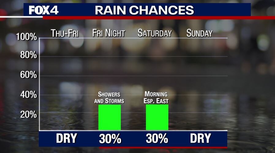
Rain Chances Return!
We have one more very warm and rain-free day for North Texas, before the next disturbance brings a chance for showers and storms Friday night into Saturday. A stronger system brings a better threat for rain and storms by next Monday, along with cooler temperatures.
We have one more very warm and rain-free day for North Texas, before the next disturbance brings a chance for showers and storms Friday night into Saturday. A stronger system brings a better threat for rain and storms by next Monday, along with cooler temperatures.

Continued Warmth!
Well above normal temperatures continue for the next several days. By Friday night, showers and storms return for some as the next cold front moves through the region. We dry out and return to normal for the weekend. Higher rain chances return next week.
Well above normal temperatures continue for the next several days. By Friday night, showers and storms return for some as the next cold front moves through the region. We dry out and return to normal for the weekend. Higher rain chances return next week.