


May 19 overnight forecast
Dan Henry has the latest forecast.
Dan Henry has the latest forecast.

May 19 afternoon forecast
Dan Henry has the latest forecast
Dan Henry has the latest forecast

May 19 morning forecast
Meteorologist Evan Andrews says the forecast calls for a little heat, then a whole LOT of humidity and a few storms thrown in.
Meteorologist Evan Andrews says the forecast calls for a little heat, then a whole LOT of humidity and a few storms thrown in.

May 18 overnight forecast
Dan Henry has the latest forecast.
Dan Henry has the latest forecast.

May 18 afternoon forecast
Dan Henry has the latest forecast.
Dan Henry has the latest forecast.
May 18 morning forecast
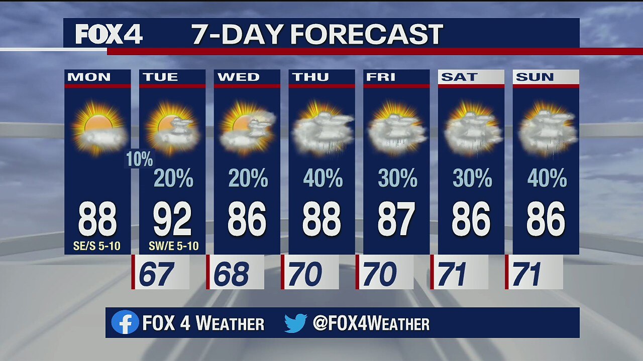
Meteorologist Evan Andrews takes a look at the forecast for the week. He says it will warm to the upper 80s Monday. Then on Tuesday, a weak front will bring more isolated gusty storms.
Meteorologist Evan Andrews takes a look at the forecast for the week. He says it will warm to the upper 80s Monday. Then on Tuesday, a weak front will bring more isolated gusty storms.

Rainy Saturday
Some areas of North Texas saw as much as 4 inches of rain on Saturday.
Some areas of North Texas saw as much as 4 inches of rain on Saturday.
May 15 overnight forecast
Dan Henry has the latest forecast.
Dan Henry has the latest forecast.
May 15 afternoon forecast
Dan Henry has the latest forecast
Dan Henry has the latest forecast

May storms will take over
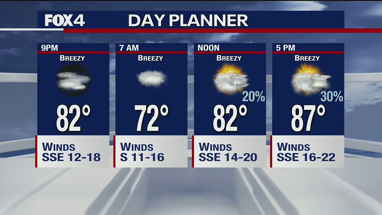
The forecast is quiet today -- breezy, humid and warm with highs in the upper 80s. Some storms could develop tonight and then heavy rain is possible over the weekend.
The forecast is quiet today -- breezy, humid and warm with highs in the upper 80s. Some storms could develop tonight and then heavy rain is possible over the weekend.

May 14 overnight forecast
Dan Henry has the latest forecast.
Dan Henry has the latest forecast.
May 14 afternoon forecast
Dan Henry has the latest forecast.
Dan Henry has the latest forecast.

May 14 morning forecast
Meteorologist Evan Andrews talks about the chance for more rain in the forecast.
Meteorologist Evan Andrews talks about the chance for more rain in the forecast.

May 13 overnight forecast
Dan Henry has the latest forecast.
Dan Henry has the latest forecast.

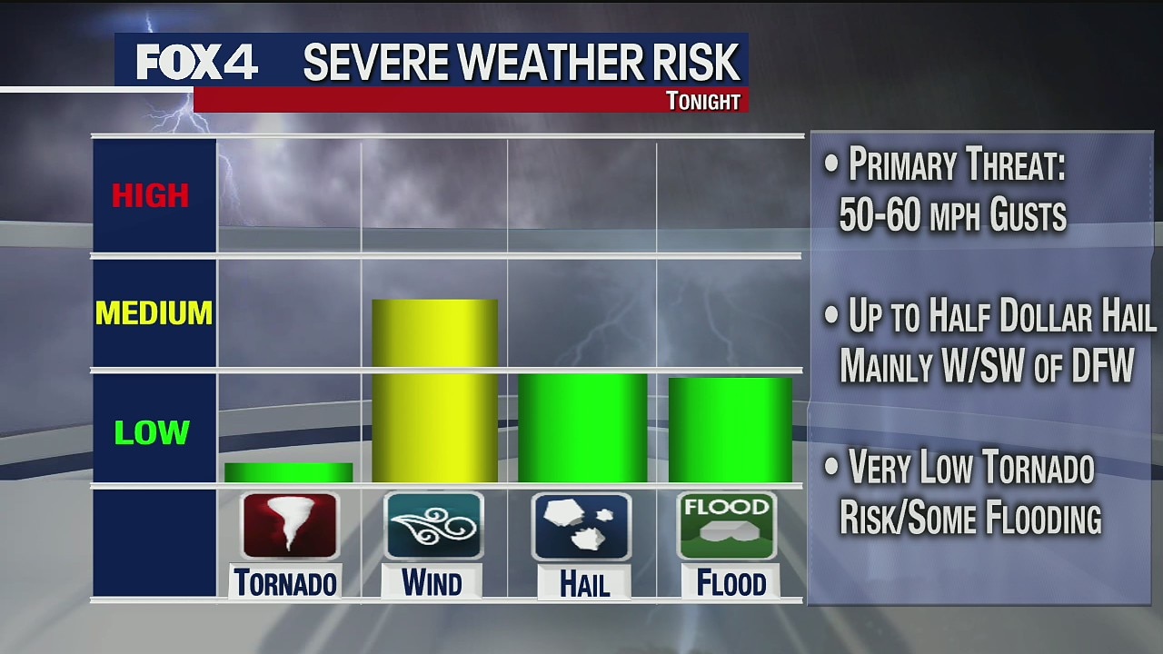
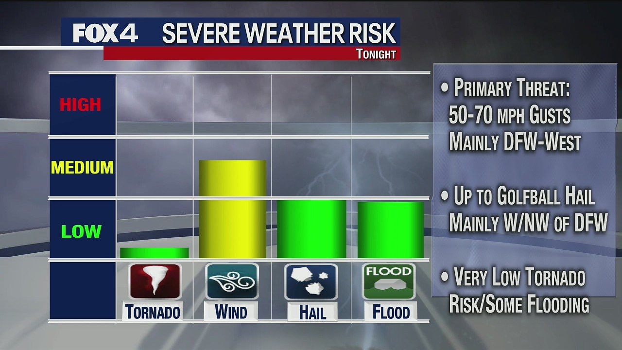
Chances of Severe Weather Overnight
There is a chance of severe weather for most of North Texas overnight Wednesday.
There is a chance of severe weather for most of North Texas overnight Wednesday.

Wednesday morning weather forecast
Meteorologist Evan Andrews gives an update on the chance of rain in the forecast.
Meteorologist Evan Andrews gives an update on the chance of rain in the forecast.

May 12 overnight forecast
Dan Henry has the latest forecast.
Dan Henry has the latest forecast.

Chance of scattered showers for some Wednesday
Temperatures return to the 80s for the rest of the work week.
Temperatures return to the 80s for the rest of the work week.

Typical May forecast... it MAY storm for some
There are showers and storms in the forecast today with higher coverage in the morning and lower coverage in the evening. But the rain is not for everyone. Meteorologist Evan Andrews has details.
There are showers and storms in the forecast today with higher coverage in the morning and lower coverage in the evening. But the rain is not for everyone. Meteorologist Evan Andrews has details.

May 11 overnight forecast
Dan Henry has the latest forecast.
Dan Henry has the latest forecast.