


May 28 morning forecast
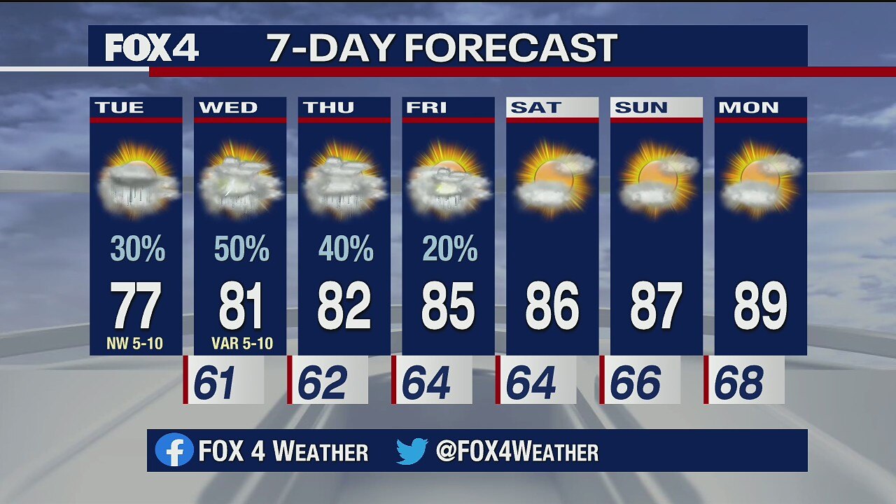
Meteorologist Evan Andrews has an update on the forecast. It's the last day for a chance of showers and then we dry up and heat up.
Meteorologist Evan Andrews has an update on the forecast. It's the last day for a chance of showers and then we dry up and heat up.

May 27 overnight forecast
Dan Henry has the latest forecast.
Dan Henry has the latest forecast.
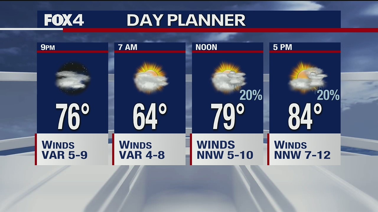
May 27 afternoon forecast
Dan Henry has the latest forecast.
Dan Henry has the latest forecast.
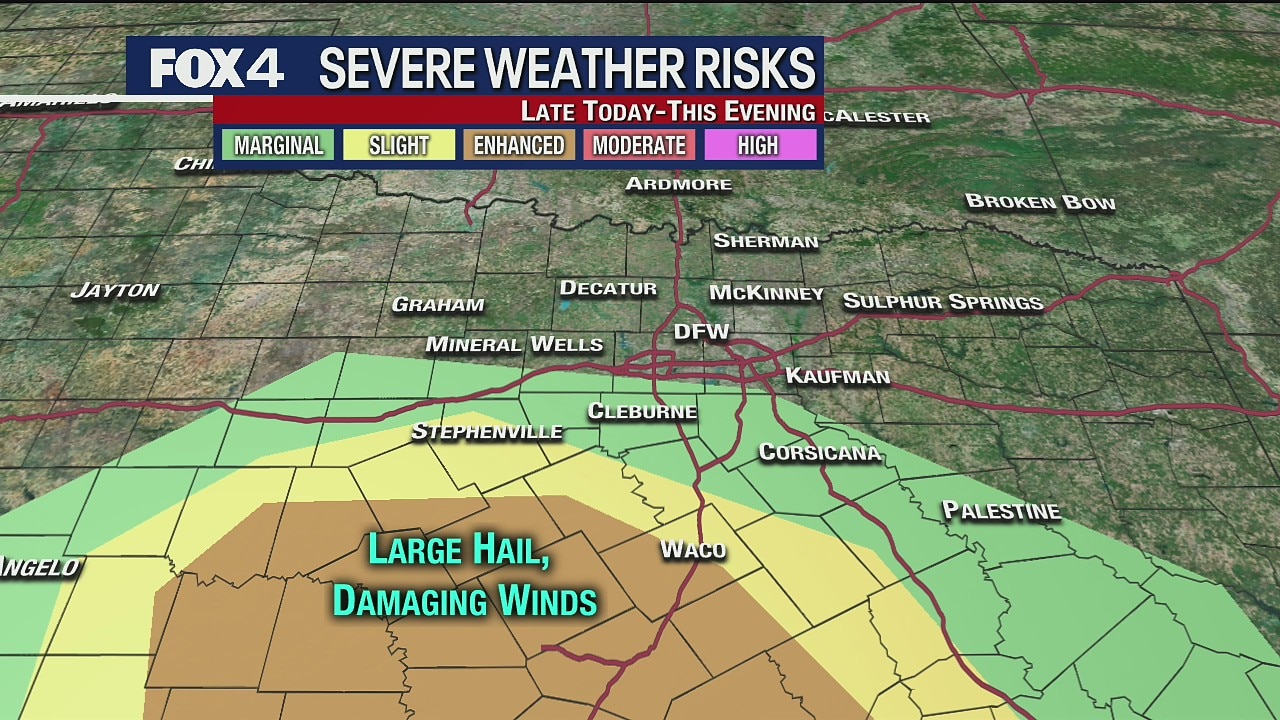
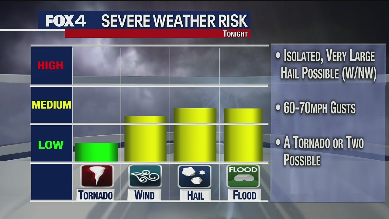
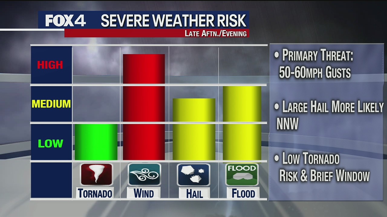
Severe weather possible for some Wednesday evening
Meteorologist Evan Andrews says the main risk for active storms will be after 4 p.m. for counties well south and southwest of Fort Worth... closer to Waco and Central Texas. Storms that do form could easily contain very large hail, and high winds.
Meteorologist Evan Andrews says the main risk for active storms will be after 4 p.m. for counties well south and southwest of Fort Worth... closer to Waco and Central Texas. Storms that do form could easily contain very large hail, and high winds.

May 26 overnight forecast
Dan Henry has the latest forecast.
Dan Henry has the latest forecast.

May 26 afternoon forecast
Dan Henry has the latest forecast.
Dan Henry has the latest forecast.
May 26 morning forecast
Meteorologist Evan Andrews takes a look at the chance for some rain in the forecast.
Meteorologist Evan Andrews takes a look at the chance for some rain in the forecast.

May 25 afternoon forecast
Ali Turiano has the latest forecast.
Ali Turiano has the latest forecast.
May 25 Midday Forecast
Evan Andrews has the latest forecast.
Evan Andrews has the latest forecast.

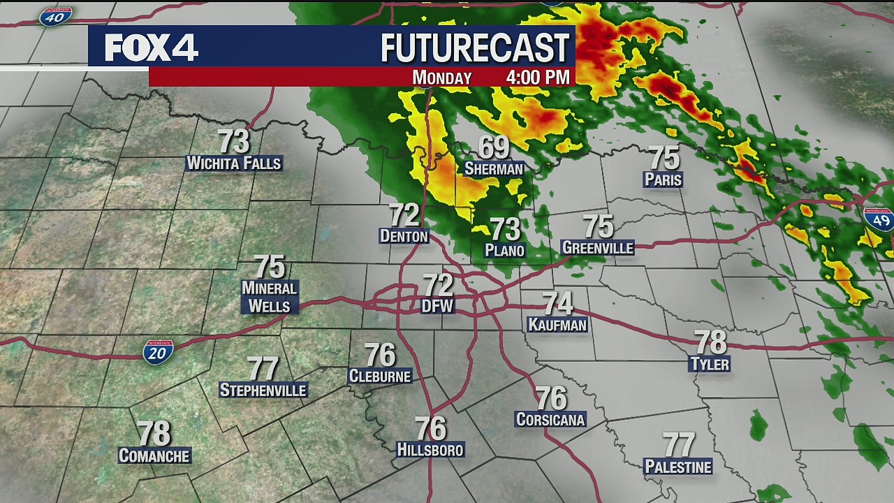
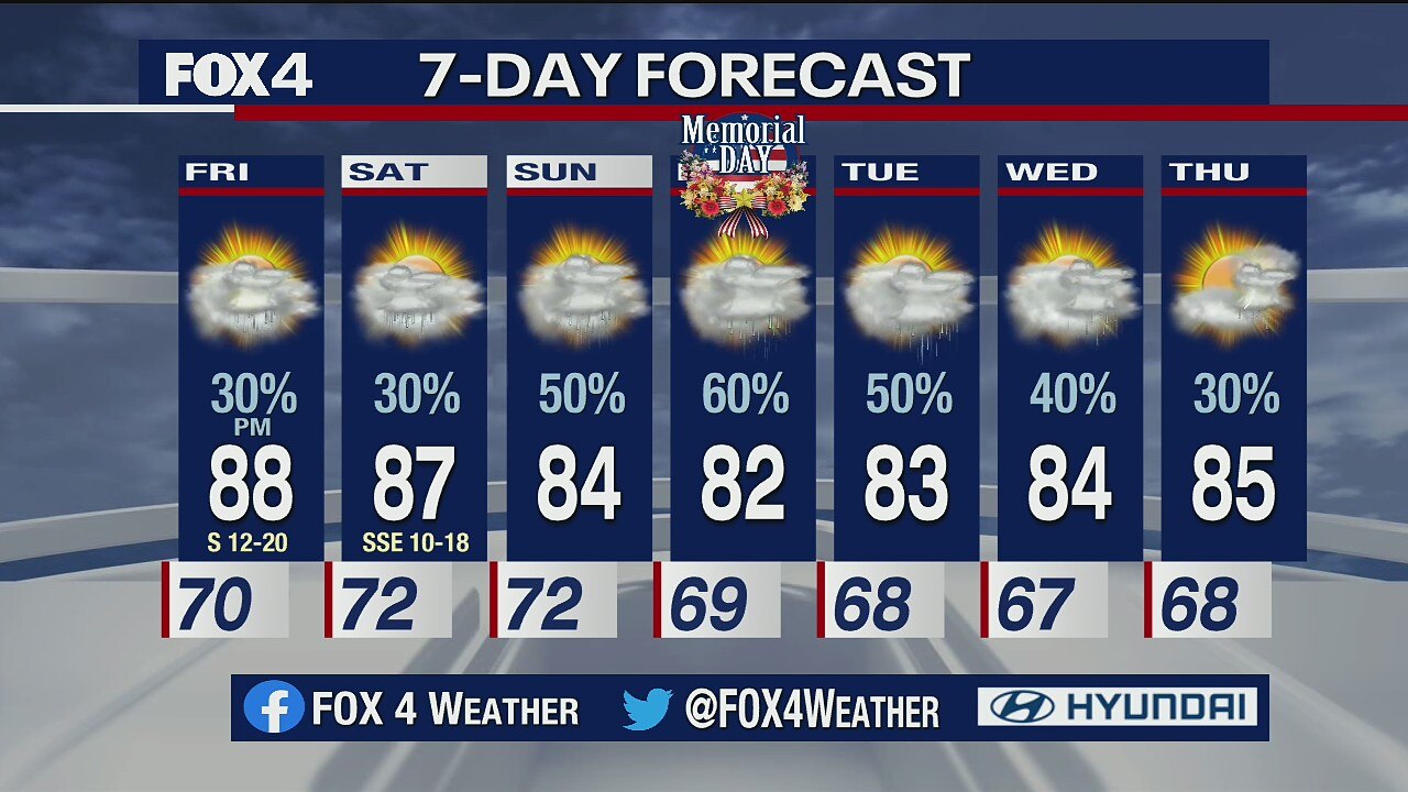
May 24 Forecast
Rain is in the forecast every day this week.
Rain is in the forecast every day this week.

May 23 Forecast
After severe storms hit North Texas Friday night, more rain could come Saturday night.
After severe storms hit North Texas Friday night, more rain could come Saturday night.
May 22 overnight forecast
Dan Henry has the latest forecast.
Dan Henry has the latest forecast.
May 22 afternoon forecast
Dan Henry has the latest forecast
Dan Henry has the latest forecast
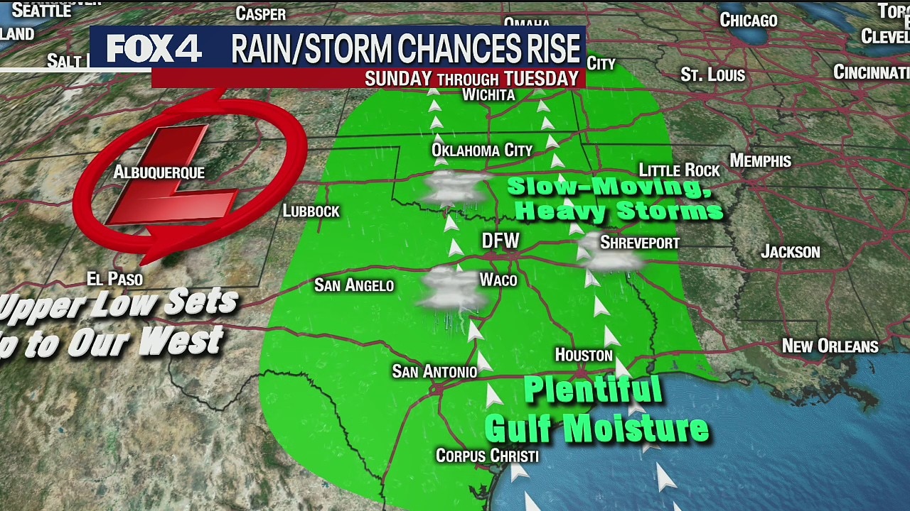
Some severe weather possible over the holiday weekend
Meteorologist Kylie Capps wishes she had better news for the forecast for the holiday weekend. There's a chance of rain and the possibility of some severe weather.
Meteorologist Kylie Capps wishes she had better news for the forecast for the holiday weekend. There's a chance of rain and the possibility of some severe weather.

May 21 overnight forecast
Dan Henry has the latest forecast
Dan Henry has the latest forecast
May 21 Evening Forecast
There are chance of rain for the rest of the week.
There are chance of rain for the rest of the week.

May 21 morning forecast
Meteorologist Kylie Capps takes a look at the rain chances in the forecast. She says there is a little bit of hope for people with outdoor plans over the Memorial Day weekend.
Meteorologist Kylie Capps takes a look at the rain chances in the forecast. She says there is a little bit of hope for people with outdoor plans over the Memorial Day weekend.

May 20 overnight forecast
Dan Henry has the latest forecast.
Dan Henry has the latest forecast.

May 20 Evening Forecast
There are chances of rain for the rest of the week.
There are chances of rain for the rest of the week.

May 20 morning forecast
Meteorologist Evan Andrews says it's not going to be as hot but still just as humid. Plus, there's rain in the forecast for some.
Meteorologist Evan Andrews says it's not going to be as hot but still just as humid. Plus, there's rain in the forecast for some.