

WATCH: Aerial view of snowy North Texas

VIDEO: Aerial view of Dallas snow
Video from the SKY 4 helicopter shows an aerial view of the Dallas-Fort Worth region on Sunday, Jan. 25, 2026. Highlights include highway road conditions, children and firefighters sledding, Downtown Dallas, and a bald eagle soaring above White Rock Lake in Dallas.
DALLAS - Photos and video from SKY 4 show all of North Texas blanketed in a few inches of snow. Snow plows and sanding trucks are also now out on the highways.
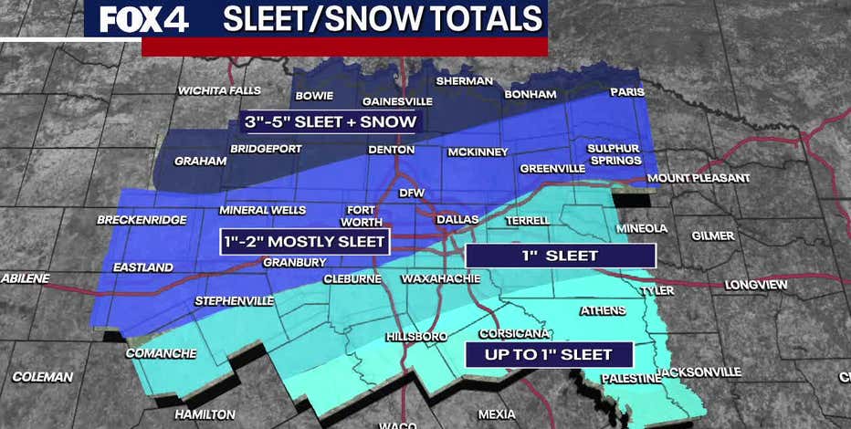
Sleet & Snow Estimations

Most of the Dallas-Fort Worth area received 1 to 2 inches of accumulation, consisting primarily of sleet. Areas north of the metroplex saw higher totals of 3 to 5 inches of a snow and sleet mix, while areas to the south reported around 1 inch.
Sunday Weather Forecast

Dallas weather: 8 a.m. update for Jan. 25, 2026
The most widespread sleet, snow, and freezing rain has occurred overnight, and is beginning to taper off from west to east this morning. A mix of sleet and snow remains possible mainly in North Texas through this afternoon, resulting in additional light accumulations.
The DFW area is now bracing for a historic cold snap this morning. Temperatures are expected to hover around 13 degrees through the morning. The sleet will transition to snow across North Texas, and flurries may continue through the afternoon with an expected high of only 19 degrees. If realized, this would set a new record for the lowest high temperature ever recorded on Jan. 25.
Dallas Weather: How much snow did Dallas get? Snow totals, power outages and dangerous -12° wind chill
Get the latest North Texas winter storm update: DFW snow and sleet totals, hazardous road conditions, and dangerous wind chills as low as -12 degrees.
Read More:
- LIVE UPDATES: Winter storm road conditions, power outages, school closings in North Texas
- Dallas winter storm: Power outages Sunday
- Dallas winter storm: Mass flight cancellations continue Sunday
- LIVE: North Texas school closings Monday
- PHOTOS: FOX 4 viewers send in Dallas winter storm pictures
Monday Weather Forecast

Photos by Kyrstain Clark w/ Clark Contracts LLC in Weatherford
Monday is shaping up to be another record-breaking day. The morning will begin with a low of 9 degrees, and afternoon highs are only expected to reach 28 degrees.
The "feels-like" temperatures will be particularly brutal, sitting at minus 5 degrees Monday morning. While skies will turn partly sunny, the region will remain below freezing. The sunshine and road treatments will aid in some melting on main highways, but motorists should be wary of black ice as surfaces will refreeze rapidly after sunset.
The Source: Information in this article comes from the National Weather Service, FOX 4 meteorologists, Texas officials and FOX 4 reporting.