


Mild Start to the Week
Sunshine and 70s start the work week, then an unsettled weather pattern sets up for several days. By Wednesday, expect more clouds and low rain chances. A cold front moves through Thursday. Cooler and wetter conditions end the work week, with clearing skies for the weekend.
Sunshine and 70s start the work week, then an unsettled weather pattern sets up for several days. By Wednesday, expect more clouds and low rain chances. A cold front moves through Thursday. Cooler and wetter conditions end the work week, with clearing skies for the weekend.
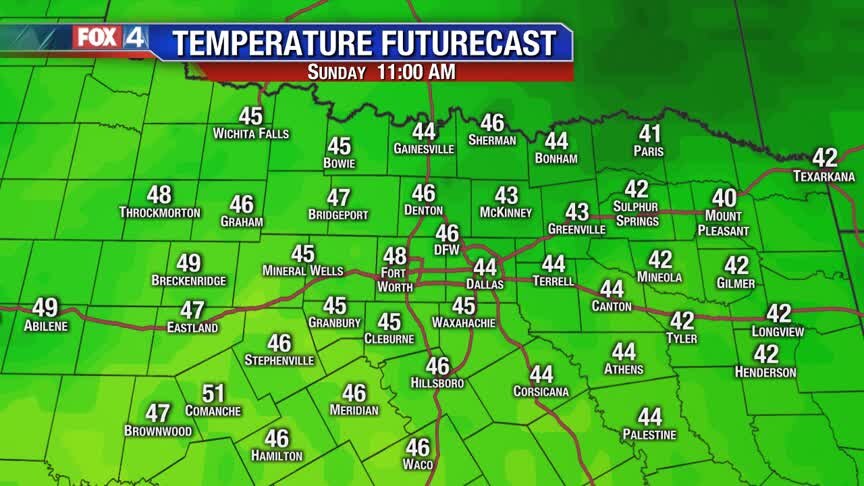
Beautiful Sunday Forecast!
A weak cold front will usher in dry air and light north winds this afternoon. Expect sunshine and highs in the 60s as we close out the weekend!
A weak cold front will usher in dry air and light north winds this afternoon. Expect sunshine and highs in the 60s as we close out the weekend!
Several Mild Days Ahead!
A cold front moves through Sunday, with little fanfare. High temperatures will still climb into the 60s. Milder conditions continue heading into the work week, as we climb above normal for several days. By mid-week, the weather pattern becomes unsettled. Rain chances and cooler temperatures return to North Texas through the end of the week.
A cold front moves through Sunday, with little fanfare. High temperatures will still climb into the 60s. Milder conditions continue heading into the work week, as we climb above normal for several days. By mid-week, the weather pattern becomes unsettled. Rain chances and cooler temperatures return to North Texas through the end of the week.

Gorgeous Weekend Ahead!
Morning! Coats needed this morning, but not this afternoon! Highs will be in the 60s for most, with plenty of sunshine.
Morning! Coats needed this morning, but not this afternoon! Highs will be in the 60s for most, with plenty of sunshine.

A Nice Weekend!
After the silly cold we have been experiencing, let's just enjoy the 60s and 70s that these next few days will bring us.
After the silly cold we have been experiencing, let's just enjoy the 60s and 70s that these next few days will bring us.
Friday Afternoon Forecast
Here's a quick look at your afternoon & weekend forecast!
Here's a quick look at your afternoon & weekend forecast!
Feeling Like Fall!
We're kicking off your Friday in the 30s, with plenty of sunshine and highs in the 50s expected this afternoon. The 60s make a return (and so does Fall...) for the weekend!
We're kicking off your Friday in the 30s, with plenty of sunshine and highs in the 50s expected this afternoon. The 60s make a return (and so does Fall...) for the weekend!

Thursday Afternoon Update
Here's a look at your Thursday afternoon forecast!
Here's a look at your Thursday afternoon forecast!
Slowly Warming Up...
We're starting in the 30s and 40s this morning, with some light rain ongoing across our southeastern counties. Skies will continue to clear all day, with abundant sunshine expected this afternoon!
We're starting in the 30s and 40s this morning, with some light rain ongoing across our southeastern counties. Skies will continue to clear all day, with abundant sunshine expected this afternoon!
Warming Up
After another sub-freezing night across North Texas, temperatures look to remain above freezing tonight. A few morning sprinkles possible southeast of DFW in the morning hours will give way to plenty of sunshine and temperatures climbing into the 50s.
After another sub-freezing night across North Texas, temperatures look to remain above freezing tonight. A few morning sprinkles possible southeast of DFW in the morning hours will give way to plenty of sunshine and temperatures climbing into the 50s.
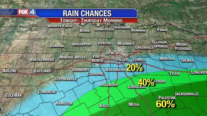
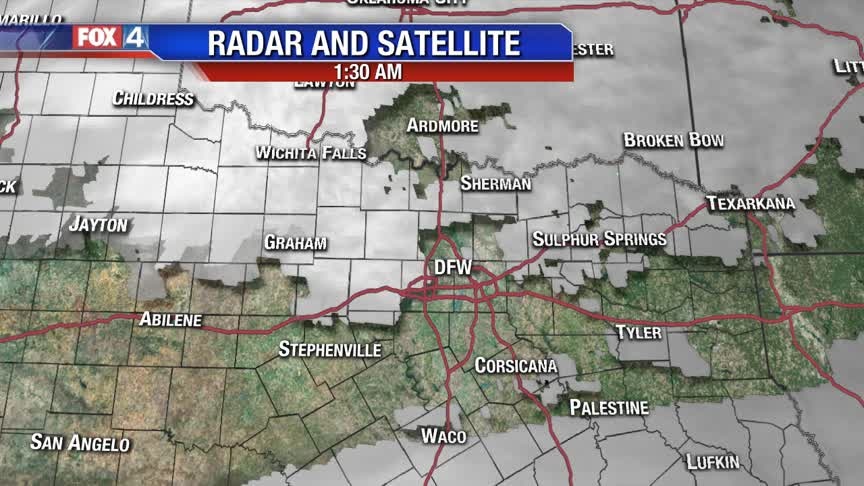
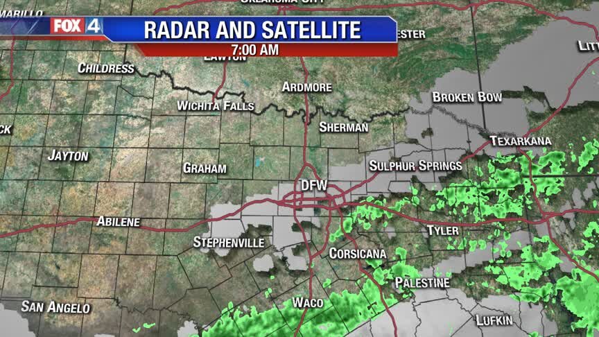
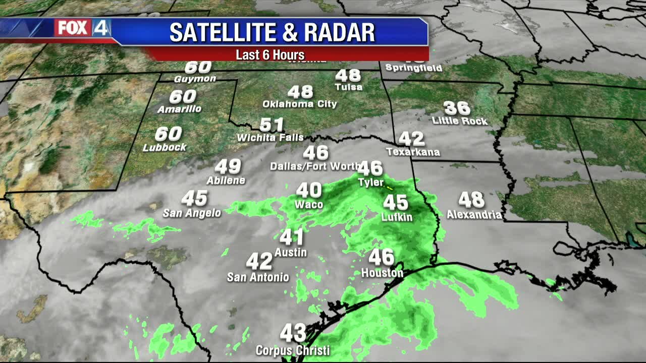
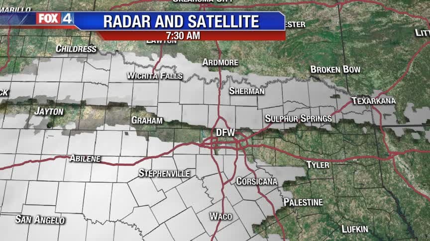
Small Rain Chances
A weak disturbance moves across south Texas bringing more clouds and low rain chances back to parts of North Texas tonight. Rain chances, mainly south and east of DFW continue Thursday, as another weak cold front moves through the region. We dry out and continue to slowly warm up heading into the weekend. By Sunday, another disturbance brings small rain chances and cooler temperatures.
A weak disturbance moves across south Texas bringing more clouds and low rain chances back to parts of North Texas tonight. Rain chances, mainly south and east of DFW continue Thursday, as another weak cold front moves through the region. We dry out and continue to slowly warm up heading into the weekend. By Sunday, another disturbance brings small rain chances and cooler temperatures.
Another Freezing Morning!
Temperatures fell into the 20s for most overnight, but we'll heat up a little warmer than yesterday. Highs will be in the low 50s, with filtered sunshine. The 60s return by the weekend, with a few showers possible on Sunday.
Temperatures fell into the 20s for most overnight, but we'll heat up a little warmer than yesterday. Highs will be in the low 50s, with filtered sunshine. The 60s return by the weekend, with a few showers possible on Sunday.
One More Frigid Night!
Another frigid night is on tap for North Texas, as lows drop into the 20s yet again. A southerly wind will begin modifying temperatures over the next several days. Expect chilly mornings and cool afternoons through the rest of the week.
Another frigid night is on tap for North Texas, as lows drop into the 20s yet again. A southerly wind will begin modifying temperatures over the next several days. Expect chilly mornings and cool afternoons through the rest of the week.
Sun Returns, Wind Decreases
After a brutally cold day, we see the winds die down taking a big bite out of the air today. Regardless, I stout arctic air mass remains with temperatures well below normal through the upcoming weekend. One more solid freeze tonight then temperatures warm into the 50s and 60s for our day time highs. Next front arrives on Sunday, but does not pack the punch that we saw on Monday.
After a brutally cold day, we see the winds die down taking a big bite out of the air today. Regardless, I stout arctic air mass remains with temperatures well below normal through the upcoming weekend. One more solid freeze tonight then temperatures warm into the 50s and 60s for our day time highs. Next front arrives on Sunday, but does not pack the punch that we saw on Monday.

Hello Winter
Readings in the 20s will slowly moderate into the low 40s with sunshine and MUCH lighter winds this afternoon.
Readings in the 20s will slowly moderate into the low 40s with sunshine and MUCH lighter winds this afternoon.
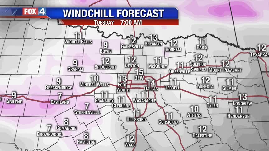
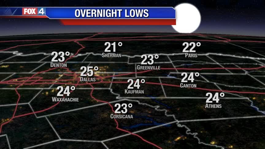
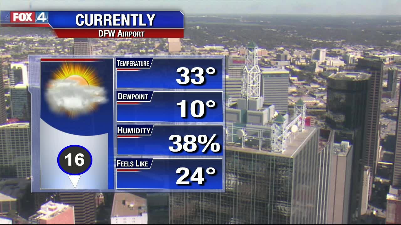
Arctic Blast!
Strong north winds have ushered in the coldest air of the season! Expect lows to drop into the 20s, with wind chills in the teens into Tuesday morning. Even with full sunshine, high temperatures only climb back into the 40s Tuesday afternoon. Expect another Hard Freeze Tuesday night, with temperatures slowly moderating through the rest of the week.
Strong north winds have ushered in the coldest air of the season! Expect lows to drop into the 20s, with wind chills in the teens into Tuesday morning. Even with full sunshine, high temperatures only climb back into the 40s Tuesday afternoon. Expect another Hard Freeze Tuesday night, with temperatures slowly moderating through the rest of the week.

Big Drop Today
One CRAZY day, then just a typical WINTER WEEK (In fall!)
One CRAZY day, then just a typical WINTER WEEK (In fall!)
Here Comes A Winter Blast!
The next cold front brings scattered showers and noticeably colder air back to North Texas to start the work week. By Monday afternoon, temperatures will be in the 40s with wind chills in the 20s and 30s. A Hard Freeze is possible both Tuesday and Wednesday morning.
The next cold front brings scattered showers and noticeably colder air back to North Texas to start the work week. By Monday afternoon, temperatures will be in the 40s with wind chills in the 20s and 30s. A Hard Freeze is possible both Tuesday and Wednesday morning.
Beautiful Sunday Forecast
Enjoy today, because big changes arrive tomorrow...here's your forecast!
Enjoy today, because big changes arrive tomorrow...here's your forecast!
One More Nice Day!
Enjoy the mild conditions for the rest of the weekend. On Monday, the next cold front brings a rain and very cold air back to North Texas. Expect hard freezes Tuesday and Wednesday morning, with temperatures staying well below normal through the week.
Enjoy the mild conditions for the rest of the weekend. On Monday, the next cold front brings a rain and very cold air back to North Texas. Expect hard freezes Tuesday and Wednesday morning, with temperatures staying well below normal through the week.