

Wednesday Afternoon Update
Here's your afternoon forecast!
Here's your afternoon forecast!
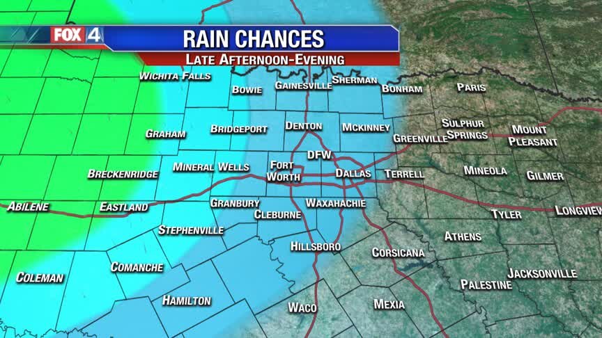
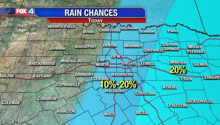
Low Rain Chances Today
We're waking up to temps in the 40s, thanks to a strong cold front last night. We'll stay in the 50s all afternoon with increasing cloud cover and a low chance for a spotty shower. Better rain chances return tonight...here's your holiday forecast!
We're waking up to temps in the 40s, thanks to a strong cold front last night. We'll stay in the 50s all afternoon with increasing cloud cover and a low chance for a spotty shower. Better rain chances return tonight...here's your holiday forecast!
Big Changes Ahead!
Warm and windy today ahead of our first of two cold fronts. Expect showers mainly east this afternoon. Behind the front, noticeably cooler air moves Wednesday. By Wednesday night, the next disturbance bring widespread rain into Thanksgiving Day. A quick warm up ensues Friday ahead of the next cold front. Strong to severe storms will be possible Friday night. We dry out and cool down for the weekend.
Warm and windy today ahead of our first of two cold fronts. Expect showers mainly east this afternoon. Behind the front, noticeably cooler air moves Wednesday. By Wednesday night, the next disturbance bring widespread rain into Thanksgiving Day. A quick warm up ensues Friday ahead of the next cold front. Strong to severe storms will be possible Friday night. We dry out and cool down for the weekend.
Warm to Cool to Wet!
Very warm air today, gives way to 50s tomorrow behind a cold front. The WETTER weather should hold off until Wed. night and Thanksgiving, with at least some showers and storms through at least Friday night or early Saturday!
Very warm air today, gives way to 50s tomorrow behind a cold front. The WETTER weather should hold off until Wed. night and Thanksgiving, with at least some showers and storms through at least Friday night or early Saturday!
From Nice to Yuck!
Mild, Spring-like conditions continue through Tuesday ahead of the first of two cold fronts. A strong disturbance brings widespread chilly rain Wednesday night and through Thanksgiving Day. A second cold front returns storms late Friday into early Saturday.
Mild, Spring-like conditions continue through Tuesday ahead of the first of two cold fronts. A strong disturbance brings widespread chilly rain Wednesday night and through Thanksgiving Day. A second cold front returns storms late Friday into early Saturday.

Nice...may turn Nasty!
We start the week mild in the 70s then turn more WILD as colder air moves in...followed by rain for Thanksgiving, and some storms possible late week.
We start the week mild in the 70s then turn more WILD as colder air moves in...followed by rain for Thanksgiving, and some storms possible late week.
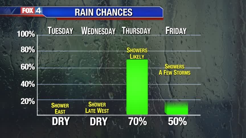
Wet & Chilly Holiday
The week starts off Spring-like and dry, but quickly changes thanks to another cold front. Showers increase late Wednesday and continue through Thanksgiving Day. Expect a chilly and wet Thanksgiving Day. Another cold front late Friday, keeps showers and storms in North Texas to start the weekend.
The week starts off Spring-like and dry, but quickly changes thanks to another cold front. Showers increase late Wednesday and continue through Thanksgiving Day. Expect a chilly and wet Thanksgiving Day. Another cold front late Friday, keeps showers and storms in North Texas to start the weekend.

Gorgeous Sunday
We're starting off chilly this morning, but most of us will top out near the 70 degree mark! Here's your forecast.
We're starting off chilly this morning, but most of us will top out near the 70 degree mark! Here's your forecast.
Mild & Dry... For Now
After a chilly morning, North Texas quickly warms up to near 70 Sunday afternoon. The warming trend continues for several days ahead of the next cold front. Several disturbances keep chilly and wet conditions in place through the Holiday.
After a chilly morning, North Texas quickly warms up to near 70 Sunday afternoon. The warming trend continues for several days ahead of the next cold front. Several disturbances keep chilly and wet conditions in place through the Holiday.

Nice Weekend Ahead!
After a cool start this morning, we will heat up into the 50s this afternoon. The upper 60s and low 70s return tomorrow...with plenty of sunshine!
After a cool start this morning, we will heat up into the 50s this afternoon. The upper 60s and low 70s return tomorrow...with plenty of sunshine!
Friday Afternoon Update
Here's your afternoon and evening forecast!
Here's your afternoon and evening forecast!
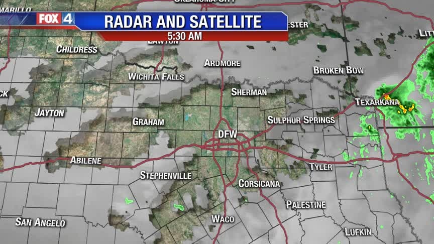
Chilly & Wet Friday Morning!
Scattered showers and storms are tapering off from the west to the east this morning. We should be dry by midday, with windy conditions continuing all afternoon. Temps won't vary much...we'll likely stay in the 40s all day. The weekend will be pleasant!
Scattered showers and storms are tapering off from the west to the east this morning. We should be dry by midday, with windy conditions continuing all afternoon. Temps won't vary much...we'll likely stay in the 40s all day. The weekend will be pleasant!
Thursday Afternoon Update
Here's a quick forecast update...
Here's a quick forecast update...
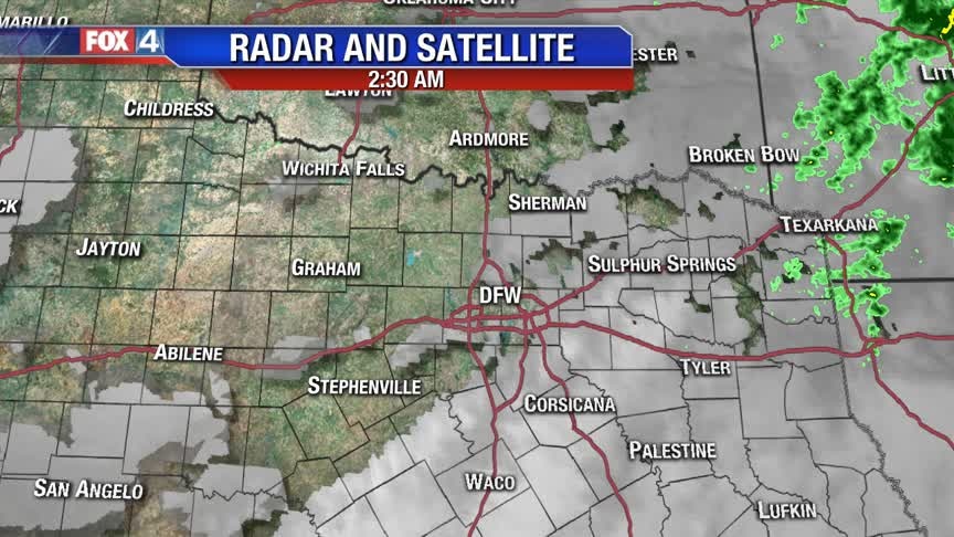
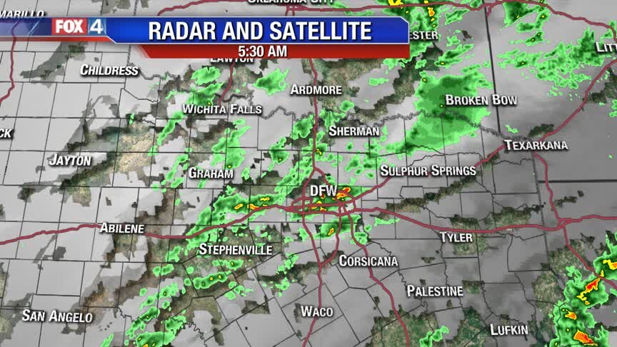
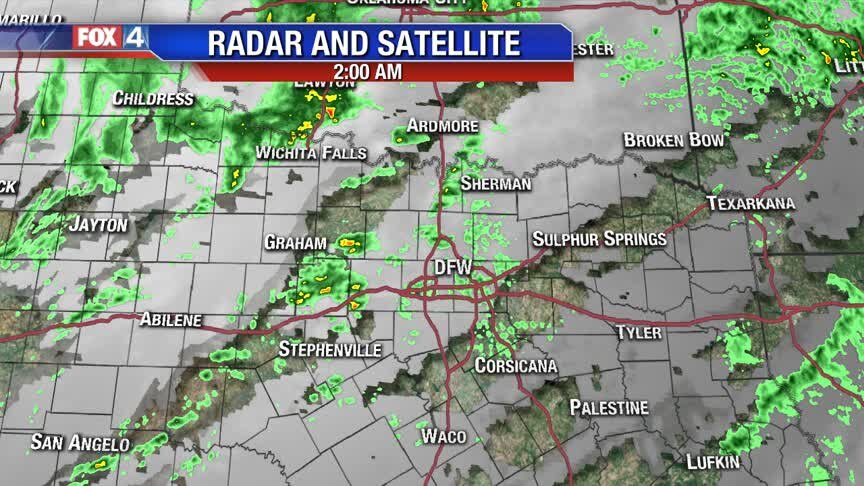
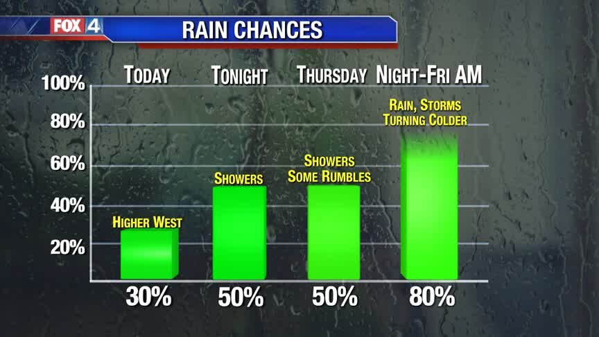
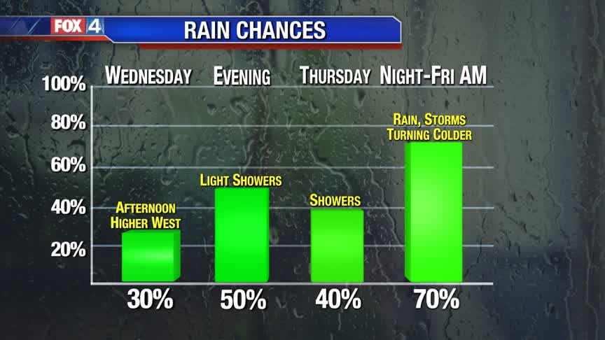
Rain Chances Continue
Another warm and muggy day is in store, with brief shower chances. Better rain/storm chances arrive overnight tonight. No severe weather is expected, Once the cold front rolls through, expect chilly rain to continue Friday morning, with temps in the 40s and 50s all day!
Another warm and muggy day is in store, with brief shower chances. Better rain/storm chances arrive overnight tonight. No severe weather is expected, Once the cold front rolls through, expect chilly rain to continue Friday morning, with temps in the 40s and 50s all day!
Rainy End to the Work Week!
Several disturbances bring showers and storms back to North Texas over the next few days. Highest coverage, with a cold front, is expected Thursday night into Friday. Noticeably cooler air moves in behind the front Friday afternoon.
Several disturbances bring showers and storms back to North Texas over the next few days. Highest coverage, with a cold front, is expected Thursday night into Friday. Noticeably cooler air moves in behind the front Friday afternoon.
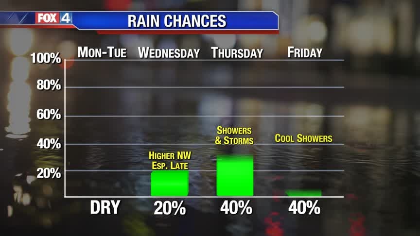
Several Rounds Of Rain Chances!
Showers become more likely later on today and overnight,,,before that, highs will be in the mid 70s for most. A cold front rolls through tomorrow night bringing widespread shower/storm chances, likely lingering into Friday morning before dry air filters in. Highs stay in the 50s both Friday and Saturday!
Showers become more likely later on today and overnight,,,before that, highs will be in the mid 70s for most. A cold front rolls through tomorrow night bringing widespread shower/storm chances, likely lingering into Friday morning before dry air filters in. Highs stay in the 50s both Friday and Saturday!
Here Comes the Rain!
Sunshine and mild temperatures continue today, but changes are on the way. Expect more clouds and showers to return starting Wednesday. A cold front slowly moves through North Texas, bringing more showers and storms to end the work week. Drier and cooler air moves in for the weekend.
Sunshine and mild temperatures continue today, but changes are on the way. Expect more clouds and showers to return starting Wednesday. A cold front slowly moves through North Texas, bringing more showers and storms to end the work week. Drier and cooler air moves in for the weekend.

"The Winds of Change"!
Beautiful warm 70s today, but clouds, humidity and wind increase tomorrow. Eventually that will yield showers, that become more widespread rain/storms...followed by a cool end to the week!
Beautiful warm 70s today, but clouds, humidity and wind increase tomorrow. Eventually that will yield showers, that become more widespread rain/storms...followed by a cool end to the week!
Tracking the Next Cold Front!
Sunshine and mild temperatures continue for the next couple of days. Mid-week, clouds and low rain chances return ahead of the next storm system. Scattered showers and storms move through with a cold front Thursday. Rain chances linger into Friday, as temperatures cool off. We dry out just in time for the weekend.
Sunshine and mild temperatures continue for the next couple of days. Mid-week, clouds and low rain chances return ahead of the next storm system. Scattered showers and storms move through with a cold front Thursday. Rain chances linger into Friday, as temperatures cool off. We dry out just in time for the weekend.
Warmer Week Ahead!
Sunshine and light winds will take temps into the 70s through tomorrow. Even with extra clouds (showers too), we stay in the 70s through Thursday before colder air takes over late week.
Sunshine and light winds will take temps into the 70s through tomorrow. Even with extra clouds (showers too), we stay in the 70s through Thursday before colder air takes over late week.