

Heading Back Up!
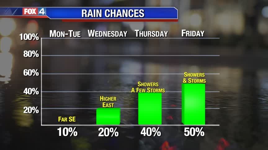
Southerly winds transport more clouds and milder air back to North Texas heading into the work week. After some morning fog, expect partly to mostly cloudy skies Monday. Highs climb back above normal, in the 60s. The warm up continues ahead of another cold front mid-week. Rain chances return starting Wednesday. Highest coverage of showers and storms is on tap Friday with a second, stronger disturbance.
Southerly winds transport more clouds and milder air back to North Texas heading into the work week. After some morning fog, expect partly to mostly cloudy skies Monday. Highs climb back above normal, in the 60s. The warm up continues ahead of another cold front mid-week. Rain chances return starting Wednesday. Highest coverage of showers and storms is on tap Friday with a second, stronger disturbance.

From Storms To Snow To Sun and Now Spring
More sunshine in the forecast to close out the weekend, this along with southerly winds will help bring our afternoon temps to near 60? for the high. 70s await us later this week!
More sunshine in the forecast to close out the weekend, this along with southerly winds will help bring our afternoon temps to near 60? for the high. 70s await us later this week!
Chilly Tonight, Then A Warm Up!
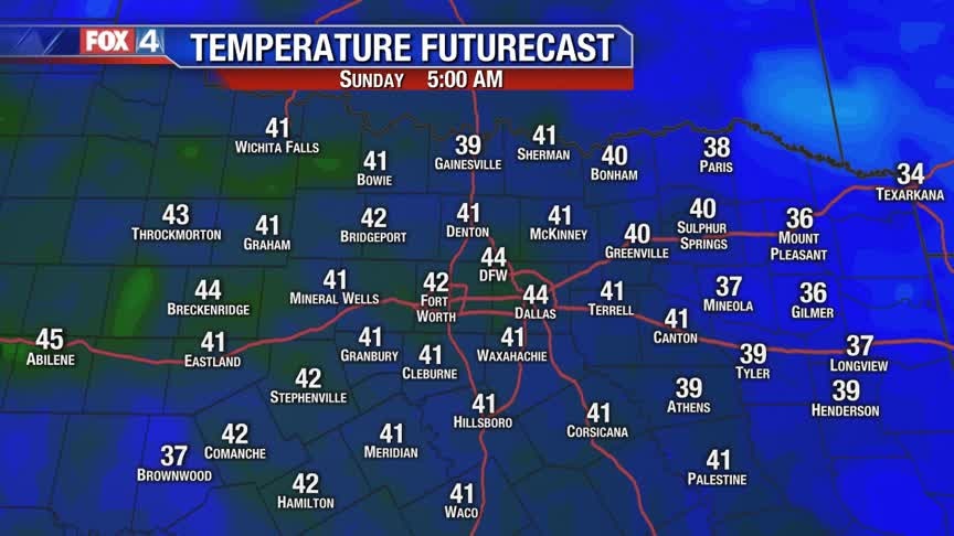
Clear skies and light winds allow temperatures to drop below freezing for many tonight. South winds develop Sunday, which help warm us back to near 60 degrees. The warm up continues into next week. An active weather pattern returns mid to late week, increasing rain chances.
Clear skies and light winds allow temperatures to drop below freezing for many tonight. South winds develop Sunday, which help warm us back to near 60 degrees. The warm up continues into next week. An active weather pattern returns mid to late week, increasing rain chances.

Winter Wonderland
A wintry mix for the remainder of the morning with clearing skies this afternoon. It's a chilly one today with cold wind chill values. Don't worry, 60s return tomorrow!
A wintry mix for the remainder of the morning with clearing skies this afternoon. It's a chilly one today with cold wind chill values. Don't worry, 60s return tomorrow!
Jan. 10 early evening update
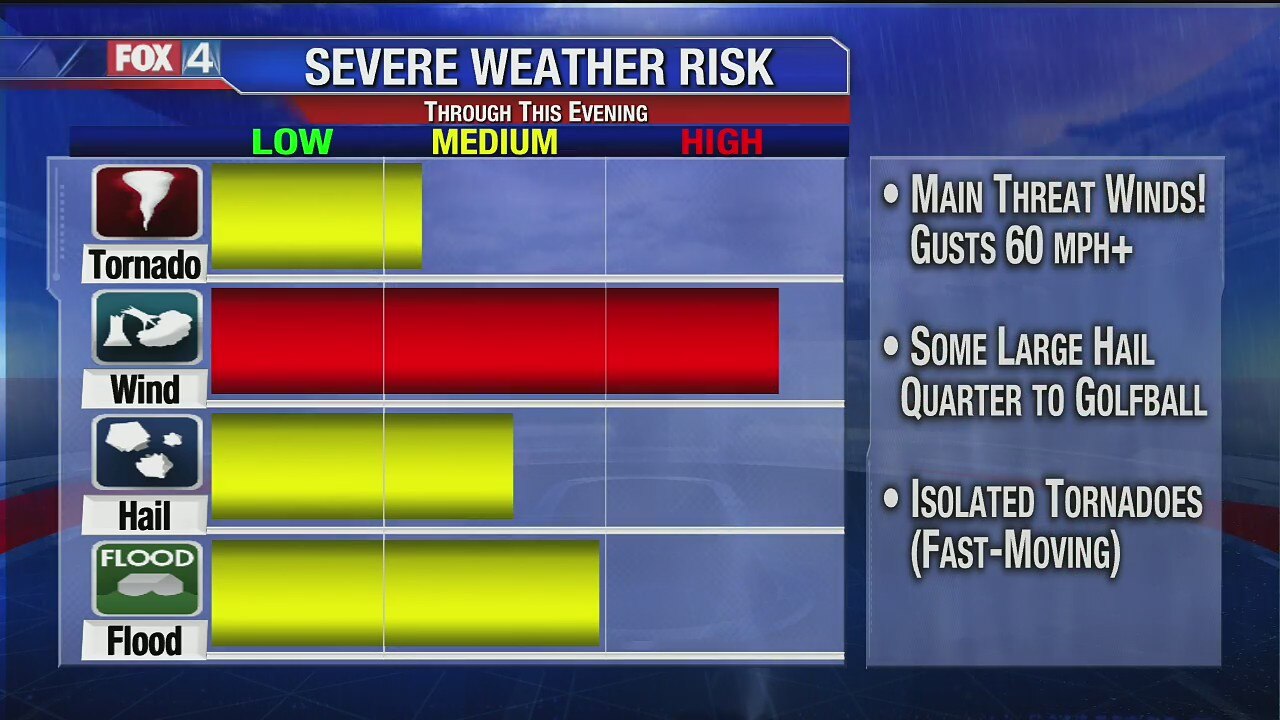
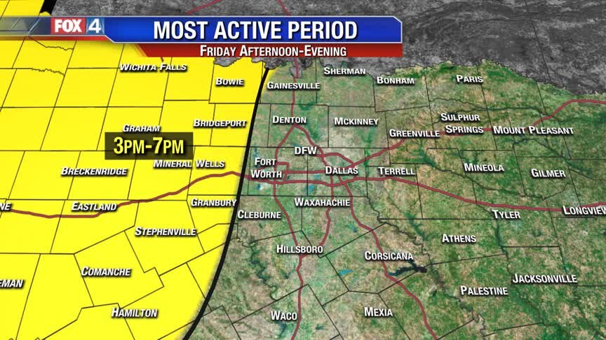
A severe weather threat for North Texas on Friday could mean damaging wind gusts, large hail and some isolated tornadoes.
A severe weather threat for North Texas on Friday could mean damaging wind gusts, large hail and some isolated tornadoes.
Jan. 10 midday forecast
A severe weather threat for North Texas on Friday could mean damaging wind gusts, large hail and some isolated tornadoes.
A severe weather threat for North Texas on Friday could mean damaging wind gusts, large hail and some isolated tornadoes.
Today's Severe Weather Threat
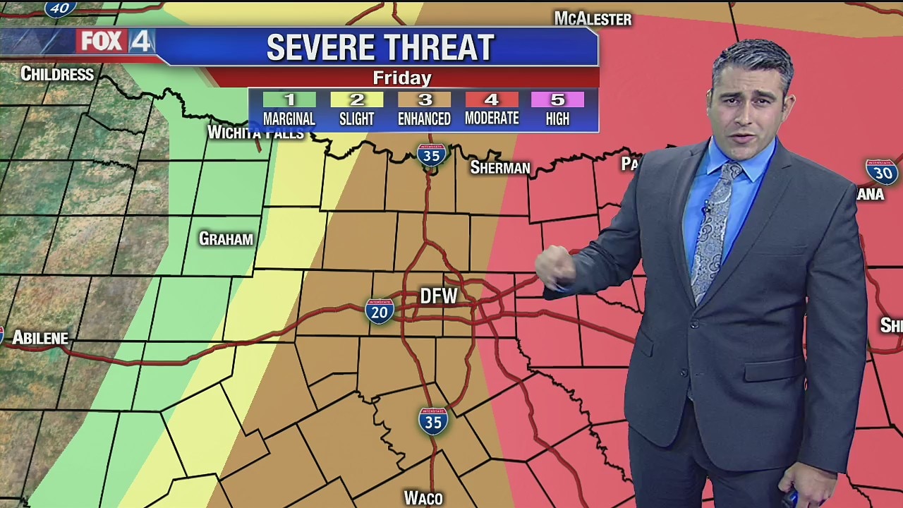
Here's an updated look at timing and threats for today's severe weather threat.
Here's an updated look at timing and threats for today's severe weather threat.
Thursday Afternoon Update
Here's a quick look at the afternoon forecast!
Here's a quick look at the afternoon forecast!

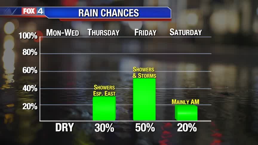
Some Showers Today
Spotty showers today, with better storm chances arriving tomorrow.
Spotty showers today, with better storm chances arriving tomorrow.
Wednesday Afternoon Forecast
Here's a quick look at the afternoon!
Here's a quick look at the afternoon!
Wednesday Morning Forecast
Another chilly morning, with a pleasant afternoon forecast with highs in the 60s. One more quiet day before significant storm chances arrive Friday. The weekend stays cool!
Another chilly morning, with a pleasant afternoon forecast with highs in the 60s. One more quiet day before significant storm chances arrive Friday. The weekend stays cool!

Storms On The Way!
North Texas remain mild and quiet for just a little while longer. By the end of the work week, a strong disturbance brings widespread showers and storms. Some storms will be strong to severe, with the greatest chances from DFW eastward. Behind this system, much cooler air returns for the weekend.
North Texas remain mild and quiet for just a little while longer. By the end of the work week, a strong disturbance brings widespread showers and storms. Some storms will be strong to severe, with the greatest chances from DFW eastward. Behind this system, much cooler air returns for the weekend.
From Mild to Wild?!
Very pleasant next couple of days, but eventually the warmth will mean a chance for storms by Friday!
Very pleasant next couple of days, but eventually the warmth will mean a chance for storms by Friday!

Changes Later This Week!
Mild temperatures and rain-free conditions continue through mid-week across North Texas. A strong disturbance to our west brings a threat for strong storms by Friday afternoon. The greatest chance for these storms will be from the I-35 Corridor eastward. Behind this storm system, much cooler air moves in for the weekend.
Mild temperatures and rain-free conditions continue through mid-week across North Texas. A strong disturbance to our west brings a threat for strong storms by Friday afternoon. The greatest chance for these storms will be from the I-35 Corridor eastward. Behind this storm system, much cooler air moves in for the weekend.
Monday Afternoon Update
Mild to warm winter week with wet weather to finish! Mostly sunny skies get us back into the 60s PM. Slightly cooler Tue, but still sunny...and still relatively mild. South winds increase Wed. Mostly cloudy (few showers Thu) with showers/storms Friday.
Mild to warm winter week with wet weather to finish! Mostly sunny skies get us back into the 60s PM. Slightly cooler Tue, but still sunny...and still relatively mild. South winds increase Wed. Mostly cloudy (few showers Thu) with showers/storms Friday.
First Monday of 2020
Mild to warm winter week with wet weather to finish! Mostly sunny skies get us back into the 60s PM. Slightly cooler Tue, but still sunny...and still relatively mild. South winds increase Wed. Mostly cloudy (few showers Thu) with showers/storms Friday.
Mild to warm winter week with wet weather to finish! Mostly sunny skies get us back into the 60s PM. Slightly cooler Tue, but still sunny...and still relatively mild. South winds increase Wed. Mostly cloudy (few showers Thu) with showers/storms Friday.
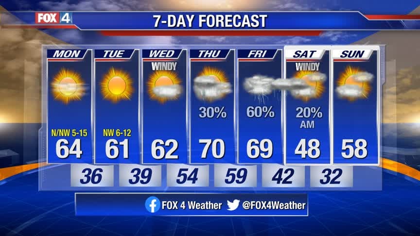
Quiet Start to the Week!
Chilly mornings and pleasant afternoons for the first half of the week! A disturbance returns rain chances starting Thursday. Strong storms will be possible Friday, especially east of DFW.
Chilly mornings and pleasant afternoons for the first half of the week! A disturbance returns rain chances starting Thursday. Strong storms will be possible Friday, especially east of DFW.
Mild & Breezy Sunday
A weak front stalls across North Texas Sunday. With no moisture to work with, expect plenty of sunshine and above normal temperatures. Next week starts out quiet, but the next disturbance out west returns rain chances by Thursday. Expect unsettled weather to continue into next weekend.
A weak front stalls across North Texas Sunday. With no moisture to work with, expect plenty of sunshine and above normal temperatures. Next week starts out quiet, but the next disturbance out west returns rain chances by Thursday. Expect unsettled weather to continue into next weekend.

Nice Weekend Warmup!
Sunshine and the 60s today...near 70 tomorrow! Here's a look at the weekend.
Sunshine and the 60s today...near 70 tomorrow! Here's a look at the weekend.

Nice Winter Weekend!
Cooler today, thanks to a weak cold front. But we warm up nicely this weekend...sunshine & the 60s!
Cooler today, thanks to a weak cold front. But we warm up nicely this weekend...sunshine & the 60s!