


Big Warm Up
Up and down we go...Clouds give way to a bit of PM sun Friday, but still quite cool. Sunshine and warmer temps this weekend with highs around 70 by Sunday. It will be mild to start next week, then turning much cooler as a strong cold front moves in Tuesday.
Up and down we go...Clouds give way to a bit of PM sun Friday, but still quite cool. Sunshine and warmer temps this weekend with highs around 70 by Sunday. It will be mild to start next week, then turning much cooler as a strong cold front moves in Tuesday.

Thursday Afternoon Forecast
Here's a look at your chilly afternoon forecast!
Here's a look at your chilly afternoon forecast!
Another Dreary Day...
Cloudy & chilly all day today! A few showers can't be ruled out this afternoon/evening, with higher coverage southeast. We stay in the 40s all day!
Cloudy & chilly all day today! A few showers can't be ruled out this afternoon/evening, with higher coverage southeast. We stay in the 40s all day!

Feeling Like January!
Cold this morning, but rain chances ended overnight. We stay in the 40s and low 50s all afternoon!
Cold this morning, but rain chances ended overnight. We stay in the 40s and low 50s all afternoon!

One System Exits, Another On The Way
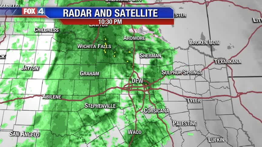
Showers and storms end quickly this evening, as a cold front heads southeast. Behind the front, strong northerly winds usher in chilly air for the next several days. Another disturbance returns small rain chances late Thursday into Friday. We dry out and warm up for the weekend.
Showers and storms end quickly this evening, as a cold front heads southeast. Behind the front, strong northerly winds usher in chilly air for the next several days. Another disturbance returns small rain chances late Thursday into Friday. We dry out and warm up for the weekend.
Cooler (Still wet!) End to January
First batch is moving out...but more to follow! Enjoy the "mild" air today, as we turn colder to end the month!
First batch is moving out...but more to follow! Enjoy the "mild" air today, as we turn colder to end the month!

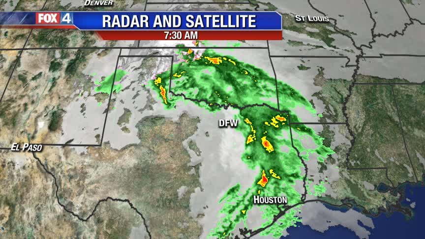
Rain Moves In Tonight!
The next disturbance brings widespread showers overnight and through much of Tuesday. Cooler are moves in behind the cold front and sticks around for the rest of the work week. Another disturbance brings a shot of rain Thursday into Friday. We dry out and warm up for the weekend.
The next disturbance brings widespread showers overnight and through much of Tuesday. Cooler are moves in behind the cold front and sticks around for the rest of the work week. Another disturbance brings a shot of rain Thursday into Friday. We dry out and warm up for the weekend.
More Rain On The Way!
After a foggy start to the day, expect some breaks in the clouds this afternoon. Most areas will climb into the 60s, with the exception of our eastern counties. Overnight, rain returns as the next cold front moves into west Texas. Widespread showers and a few rumbles are expected through Tuesday morning. Once the front moves through, North Texas dries out late in the day. The active weather pattern continues, with another disturbance by Thursday.
After a foggy start to the day, expect some breaks in the clouds this afternoon. Most areas will climb into the 60s, with the exception of our eastern counties. Overnight, rain returns as the next cold front moves into west Texas. Widespread showers and a few rumbles are expected through Tuesday morning. Once the front moves through, North Texas dries out late in the day. The active weather pattern continues, with another disturbance by Thursday.
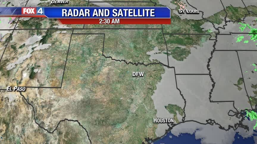
More RAIN on the way....
The FOG will burn off and we get a milder afternoon BUT the next chance for RAIN arrives late tonight...followed by additional chances later this week.
The FOG will burn off and we get a milder afternoon BUT the next chance for RAIN arrives late tonight...followed by additional chances later this week.
Tracking More Rain Chances!
Before the next disturbance arrives, North Texas will likely be socked in Monday morning with fog and drizzle. Once that burns off, expect a few breaks in the clouds and mild afternoon temperatures. Starting Monday night, showers increase in coverage. Widely scattered showers and a few storms move through Tuesday. Noticeably cooler, but near normal temperatures return for the rest of the work week.
Before the next disturbance arrives, North Texas will likely be socked in Monday morning with fog and drizzle. Once that burns off, expect a few breaks in the clouds and mild afternoon temperatures. Starting Monday night, showers increase in coverage. Widely scattered showers and a few storms move through Tuesday. Noticeably cooler, but near normal temperatures return for the rest of the work week.
Satisfying Sunday
Half of us woke up to clouds over head, but we're going to end the weekend with a fair amount of sunshine and mild temperatures in the mid 60s. After a foggy/misty start to the work week, we will see rain return to North Texas starting late Monday night for our western counties and carrying over into the rest of North Texas by Tuesday. Temperatures will also return to seasonal once the rain clears out with highs in the mid to upper 50s through Friday.
Half of us woke up to clouds over head, but we're going to end the weekend with a fair amount of sunshine and mild temperatures in the mid 60s. After a foggy/misty start to the work week, we will see rain return to North Texas starting late Monday night for our western counties and carrying over into the rest of North Texas by Tuesday. Temperatures will also return to seasonal once the rain clears out with highs in the mid to upper 50s through Friday.
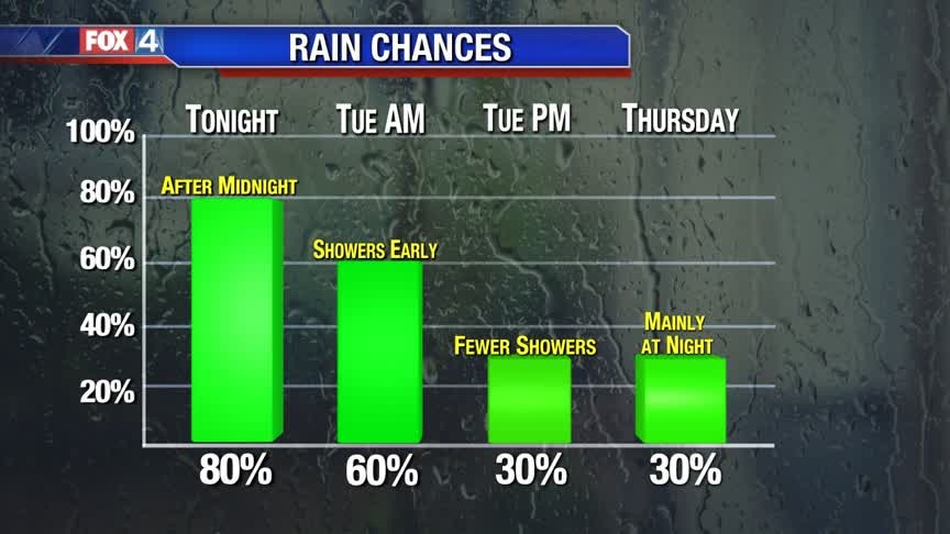
Small Rain Chances
A weak front brings in some showers overnight. Mild temperatures continue for just a little while longer behind the front. A disturbance brings widespread showers and some storms Tuesday. Temperatures drop back to normal for the rest of the week.
A weak front brings in some showers overnight. Mild temperatures continue for just a little while longer behind the front. A disturbance brings widespread showers and some storms Tuesday. Temperatures drop back to normal for the rest of the week.
Mild Weekend, Rain Tonight
The weekend will be well above average with highs in the mid-60s extending into Monday. We have some minor rain chances late tonight into the overnight time period, but most will remain dry. Better rain chances hold off until Monday night and Tuesday.
The weekend will be well above average with highs in the mid-60s extending into Monday. We have some minor rain chances late tonight into the overnight time period, but most will remain dry. Better rain chances hold off until Monday night and Tuesday.

Slight Chance of Rain
Weekend overall will be decent with a minor chance of rain late Saturday into very early Sunday morning. The rain chances will not be promising either, with only a 30% probability. Temperatures will be into the 60s for the weekend and carry over into the work week. A slightly better chance of rain takes aim for Tuesday and even that will not be a washout.
Weekend overall will be decent with a minor chance of rain late Saturday into very early Sunday morning. The rain chances will not be promising either, with only a 30% probability. Temperatures will be into the 60s for the weekend and carry over into the work week. A slightly better chance of rain takes aim for Tuesday and even that will not be a washout.
Nice Weekend Ahead!
Today will feature sunshine and highs near 60. Aside from a couple of spotty showers overnight Saturday, we'll be looking at mild & dry conditions this weekend.
Today will feature sunshine and highs near 60. Aside from a couple of spotty showers overnight Saturday, we'll be looking at mild & dry conditions this weekend.
Thursday Afternoon Forecast
Clouds are clearing & temps will climb into the 50s this afternoon!
Clouds are clearing & temps will climb into the 50s this afternoon!
Drier and Milder!
The clouds will break up later today and that should take us into at least the START of the weekend with pleasant January weather!
The clouds will break up later today and that should take us into at least the START of the weekend with pleasant January weather!

Rain Comes to an End!
Patchy drizzle and fog is expect this evening, with one more round of showers overnight. As this disturbance exits, northwest winds take over ushering in drier air Thursday. Temperatures rebound through the rest of the week. Another fast-moving disturbance brings another shot for rain Saturday into Sunday.
Patchy drizzle and fog is expect this evening, with one more round of showers overnight. As this disturbance exits, northwest winds take over ushering in drier air Thursday. Temperatures rebound through the rest of the week. Another fast-moving disturbance brings another shot for rain Saturday into Sunday.
Cold & Soggy!
On and off showers and chilly temperatures continue through the day. A cold front finally moves through early Thursday, clearing out the clouds and rain. Sunshine and milder temperatures return to end the week. Another fast-moving disturbance brings a quick shot of rain Saturday night into Sunday morning.
On and off showers and chilly temperatures continue through the day. A cold front finally moves through early Thursday, clearing out the clouds and rain. Sunshine and milder temperatures return to end the week. Another fast-moving disturbance brings a quick shot of rain Saturday night into Sunday morning.
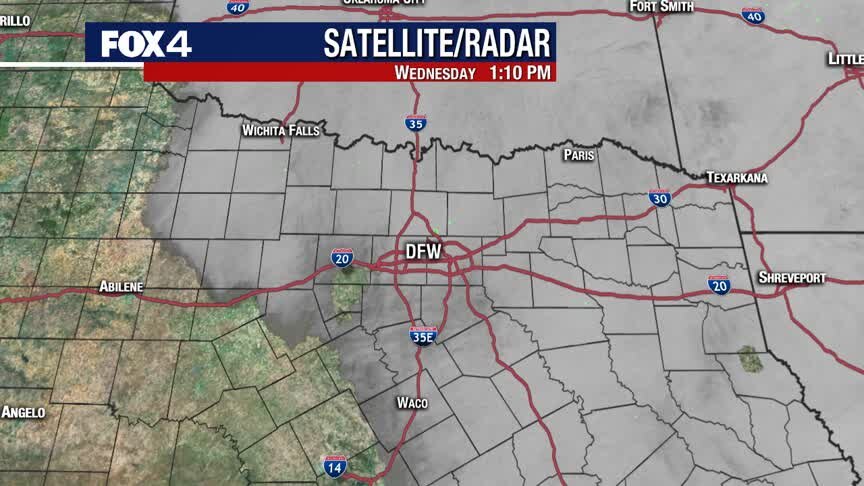
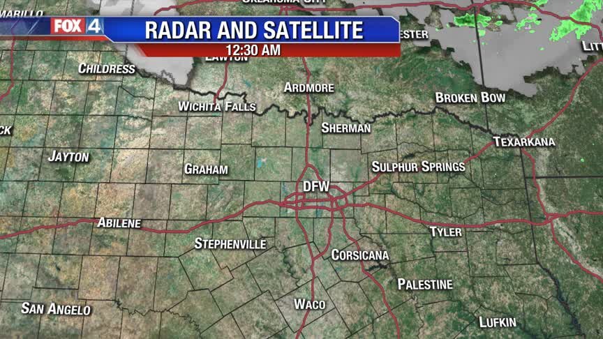
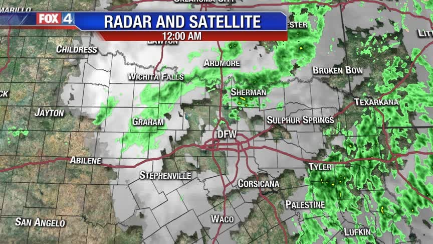
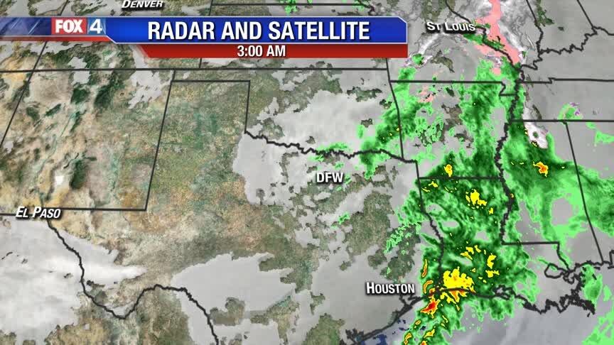
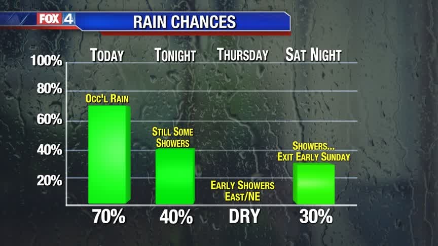
Cold & Rainy Wednesday!
Off and on light showers are expected throughout the majority of the day today. Temperatures will stay in the 40s!
Off and on light showers are expected throughout the majority of the day today. Temperatures will stay in the 40s!