Dallas Weather: Tornado damages several homes in Navarro County

Tornado damages several homes in Navarro County
There's damage from reported tornadoes that broke out Friday afternoon across several north and central Texas counties.
DALLAS - There's damage from reported tornadoes that broke out Friday afternoon across several north and central Texas counties.
The National Weather Service will determine the strength of a tornado that touched down in rural parts of Navarro County Friday afternoon.
County officials say they have not heard of any injuries so far, but there was some severe damage and close calls.
In western Navarro County, some people who live around the city of Frost found themselves in a tornado's path.

Possible tornado in Navarro County
Shane Brooks shared video of a tornado in Barry, which is in Navarro County, on April 26, 2024.
Melanie Cagle wasn't home at the time, but her son was.
"Literally just called him and said, ‘Is everything good?’ He said, 'Yeah, everything's fine.’ Until it wasn't," she recalled. "And then he just hit the bathtub and waited for it to be done, then called me with, ‘Hey, you have no more trees. Your barn’s gone. Your storage is gone, but we're okay.’"
Their neighbors at properties across the street bore the brunt of it, but, thankfully, no one there was home.
"Driving up was worse just because of my neighbor’s house. She lost everything, and it's literally right across the street from me," Cagle said. "So we're blessed. We're fine. We're good."

David Brewer is the Precinct 4 commissioner for Navarro County.
"Got lots of trees down in the roadway. Been at it since 2:30 this afternoon, and this is one of the heaviest spots right here that we've run across," he said. "A couple two or three homes have been hit pretty hard, but mostly it’s just debris and trees down in the roadways. We can replace stuff. You can't replace people."
The NWS says it will begin surveying the damage on Saturday.

Flooding in Kaufman County
Over in Kaufman County, some parts saw flash flooding from torrential rainfall.
Over in Kaufman County, some parts saw flash flooding from torrential rainfall.
Up to six inches of rain fell in the area.
The Flash Flood Warning for Kaufman County expired at 8 p.m., but there was still standing water in some areas after that.
Pictures and videos sent in by viewers show just how hard it rained and why the water accumulated so quickly.
More rain over the next few days could cause additional flooding issues.
Friday Updates
5:32 p.m.
FOX 4's Blake Hanson is in Frost, where there is damage from today's storms.
5:15 p.m.
The tornado warning in Van Zandt and Kaufman County has been allowed to expire.
4:51 p.m.
FOX 4's Blake Hanson is in Italy, Texas where there is flooding from today's storms.
4:50 p.m.
A new tornado warning has been issued for Van Zandt County until 5 p.m.
4:23 p.m.
3:42 p.m.
The City of Ennis said it has seen rain and minor flooding on the roadways. A vehicle ended up in a creek off of Walker Creek Road and Hwy 85 and the driver was rescued by EMS.
3:34 p.m.
The tornado warning in Hill County will be allowed to expire.
Meanwhile, in Corsicana, the school district has delayed all baseball and softball games until tomorrow.
3:06 p.m.

Reported tornado in Navarro County Friday afternoon
FOX 4 viewer Bill Ziegenhagen shared this video of a funnel cloud in Navarro County Friday afternoon.
3:03 p.m.
Another tornado warning was issued for Hill County until 3:45 p.m.
2:57 p.m.
The City of Waco saw damage to multiple structures from this afternoon's storms.
2:55 p.m.
The City of Irving has postponed its Music on Main concert due to tonight's severe weather risk.
2:48 p.m.
Areas are still seeing heavy rain and could produce flooding.
2:45 p.m.
The National Weather Service has allowed all tornado warnings to expire.
2:40 p.m.
Ennis ISD is delaying bus departures at all campuses.
2:31 p.m.
The tornado warning is expected to be extended to Kaufman County.
2:23 p.m.
Possible tornado in Navarro County
Shane Brooks shared video of a tornado in Barry, which is in Navarro County, on April 26, 2024.
Shane Brooks shared video of a possible tornado in the Navarro County city of Barry.
2:18 p.m.
The storms appears to be weakening as it moves closer to Ellis County, but it could redevelop.
2:06 p.m.
Ennis ISD says they are planning to dismiss school at its usual time.
1:52 p.m.
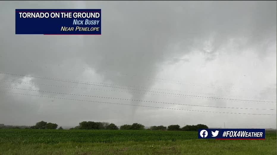
A tornado forms near Penelope, Texas on Friday, April 26. (Nick Busby)
Storm chaser Nick Busby took this photo of a possible tornado near Penelope.
You can watch a live feed of his camera here.
1:35 p.m.
The Tornado Warning has moved east. The storm system is moving toward Corsicana.
1:19 p.m.

Severe weather: Safest spots inside home, apartment
When severe storms strike and you need to take cover, here's where you should go.
If you are in an area with a tornado warning move to a safe place in your home. Put as many walls between yourself and the outside as you can.
1:14 p.m.

Tornado Watch vs. Tornado Warning: What's the difference?
FOX 4 meteorologists Dan Henry and Ali Turiano break down the differences between a tornado watch and a tornado warning.
With parts of North Texas in a Tornado Watch and central Texas in a Tornado Warning, it's important to know the difference. FOX 4 meteorologist Ali Turiano explained the difference.
1:08 p.m.
A Tornado Warning has been issued for Hill and Navarro County until 2 p.m.
1:05 p.m.
Several viewers are sending in their hail photos. You can send them to us at kdfwwebsite@fox.com
12:57 p.m.
A ground stop was issued at Dallas Love Field and DFW Airport due to the storms in the area.
12:52 p.m.
There are reports of a tornado on the ground near West.
12:51 p.m.
West, Texas is seeing a tornado warning. If you live in the area please take cover.
12:46 p.m.

Video: Hail falls in west Arlington
FOX 4 viewer Tantan Matout shared video of hail falling in west Arlington Friday afternoon.
Many FOX 4 viewers are sharing their videos hail falling in North Texas.
Arlington was one of the areas that saw the largest hail.

Hail in Arlington
FOX 4 viewer Andrew Bauer shared hail video from his home in southwest Arlington on Friday afternoon.
There were reports of hail the size of golf balls in the city.
12:42 p.m.
A tornado warning has been issued for Hill County until 1:15 p.m.
Live Radar

Saturday Forecast: Severe storm chance
Saturday can be broken down into a few different parts.
The day will start off quiet, although windy.
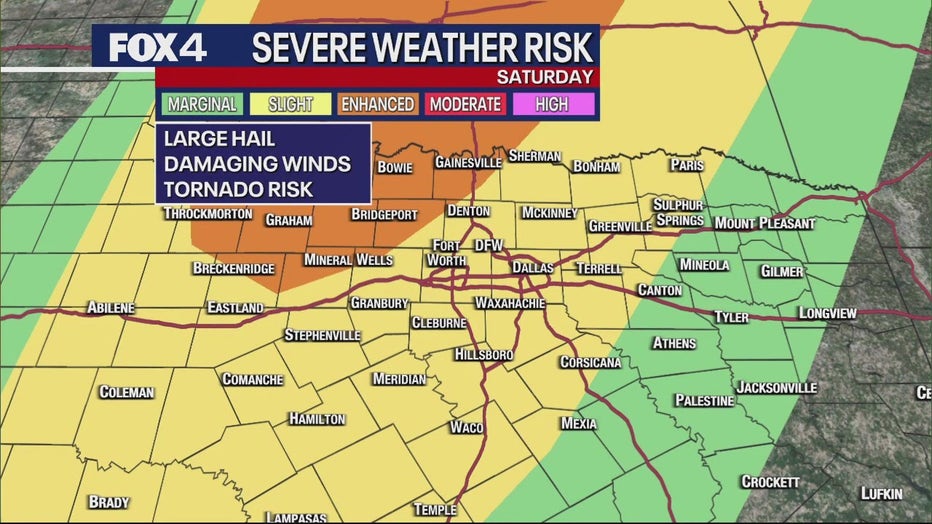
By the afternoon, storms could develop to the north and northwest of the Dallas-Fort Worth Metroplex. That will be more of a conditional threat, as a pretty strong cap will be in place.
Overnight Saturday into Sunday, the storms are expected to turn into a squall line, especially west of the Metroplex to the west.
Squall lines historically bring high winds and heavy rain.
There could also be some localized flooding and a couple of spin-up tornadoes along the leading edge.
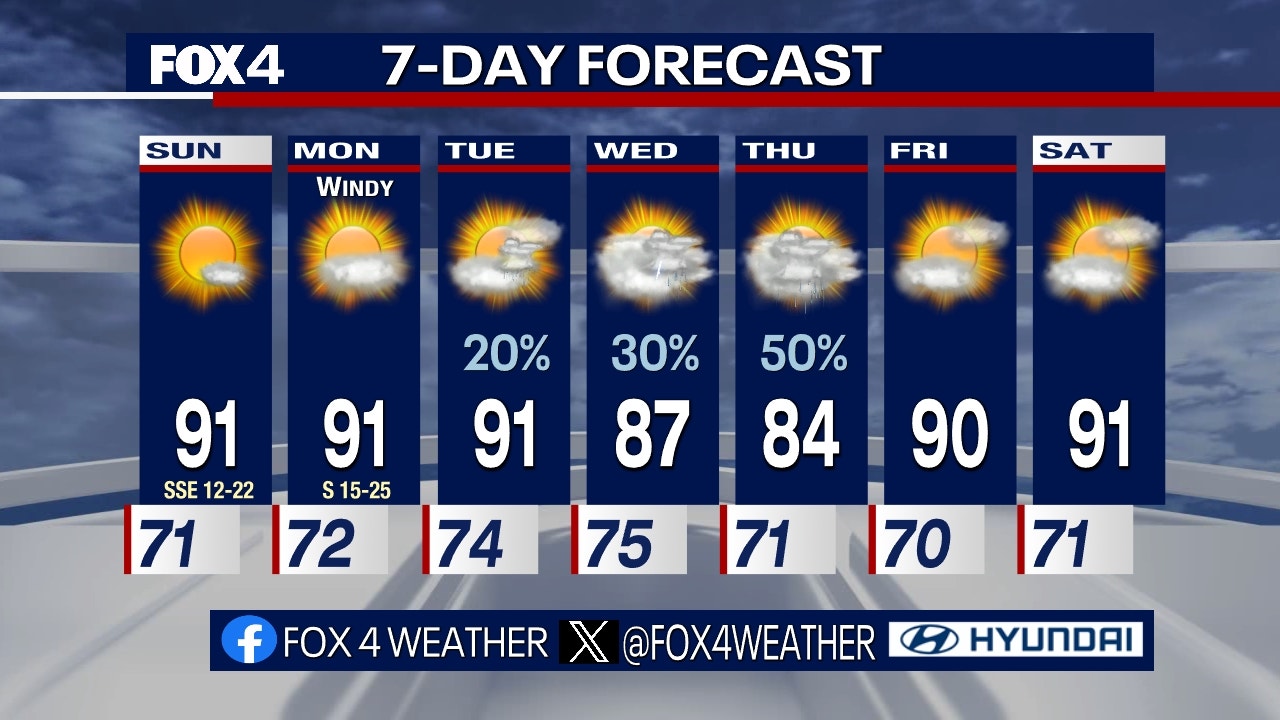
7-Day Forecast