

Dallas weather: Arctic blast timeline

Dallas weather: Jan. 13 overnight forecast
Dallas-Fort Worth is forecast to see some freezing rain and sleet on Sunday. FOX 4 meteorologist Dylan Federico walks you through the forecast, including when the chances are the highest.
Temperatures are expected to fall below freezing on Friday night ahead of an arctic blast in North Texas this weekend.
Starting Saturday night, temperatures are expected to drop below freezing for 86 straight hours.
Here's a look at what to expect.
Saturday Forecast
Things will be quite chilly by the time you wake up on Saturday.
Temperatures will climb up to the mid-50s on Saturday afternoon before the second arctic front moves through North Texas.
The front is expected to arrive Saturday evening into Saturday night, locking in the coldest air of the season so far.

Dallas weather: North Texas road crews prepare for possible icy conditions
There is potential for a wintry mix on Sunday in North Texas. Crews across North Texas, including those near Sunday's Cowboys game, are getting prepared.
Temperatures are expected to fall from the 50s around 2 p.m. Saturday, to a feels-like temperature in the teens by 9 p.m.
Those temperatures will keep falling overnight.
Sunday Forecast
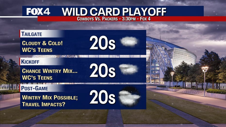
Temperatures will drop into the 20s on Sunday with wind chills falling into the single digits or even negatives in some areas.
Winds will be up to 20 mph in some spots.
According to the latest models, the best chance for a wintry mix, meaning ice, sleet or snow, would be from the overnight hours of Sunday into mid-morning Monday.
Right now, the precipitation is expected to start in some areas around 6 p.m. on Saturday and slowly ramp up throughout the night.
Things are expected to be mostly snow from the 380 corridor up to the Red River.
The snow that does fall will be dry and powdery, meaning it likely won't stick to the roadways.
The Metroplex will likely start off with some freezing rain and sleet.
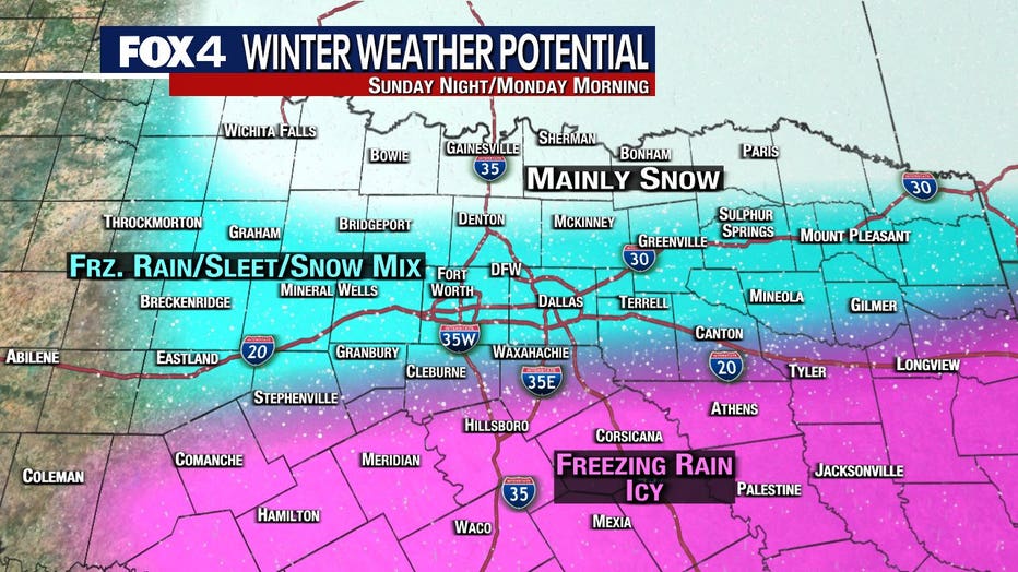
The southern part of the region will likely be freezing rain.
It could make roads dangerous Sunday night into Monday morning.
We will get a better idea of what to expect when it comes to precipitation as we get closer to Sunday.
Right now, areas to the north are expected to see snow, the Metroplex will see a wintry mix and areas to the south will be more likely to see cold rain or ice.
Monday Forecast
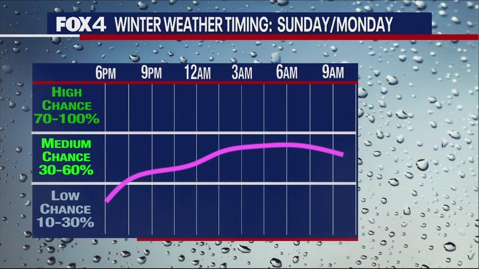
The precipitation will keep falling into the early morning hours on Monday.
The timing of the most widespread precipitation will be from about midnight to 9 a.m.
Things will taper off as we move toward lunchtime.
By the time you wake up, we're likely going to be talking about a mixture of sleet, freezing rain and snow in some spots.
It looks like north of I-20 will mostly be a dry, powdery snow, but as you get closer to the I-20 corridor you will see more of the winter mix.
Low temperatures will drop all the way into the single digits for some of us Monday morning with subzero wind chills.
That means only a little bit of precipitation will cause some major headaches for commuters.
There is not expected to be significant amounts of precipitation.
Tuesday Forecast

Things will stay bitterly cold through Tuesday, meaning we will likely spend 72-84 hours below freezing.
Temperatures are expected to rise back above freezing by Wednesday.