

Repeat Of Yesterday!
Warm today, with plenty of sunshine. Highs will be in the upper 80s!
Warm today, with plenty of sunshine. Highs will be in the upper 80s!

Warm & Dry!
Expect sunshine and 80s for the next several days. By late Friday, showers and some strong storms move through with the next cold front. The weekend will be quiet, with near normal temperatures.
Expect sunshine and 80s for the next several days. By late Friday, showers and some strong storms move through with the next cold front. The weekend will be quiet, with near normal temperatures.

Warmth & Sunshine!
Expect sunshine and 80s for the next several days. By late Friday, showers and some strong storms move through with the next cold front. The weekend will be quiet, with near normal temperatures.
Expect sunshine and 80s for the next several days. By late Friday, showers and some strong storms move through with the next cold front. The weekend will be quiet, with near normal temperatures.

Drying Out & Warming Up!
Clouds and isolated showers linger for Monday. Starting Tuesday, sunshine and noticeably warmer conditions return. By the end of the week, another cold front brings a chance of showers and storms. Behind the front, cooler air returns North Texas to normal for the weekend.
Clouds and isolated showers linger for Monday. Starting Tuesday, sunshine and noticeably warmer conditions return. By the end of the week, another cold front brings a chance of showers and storms. Behind the front, cooler air returns North Texas to normal for the weekend.

Last Gray Day?!
Clouds...some fog and a spat of drizzle today before drier air comes in tomorrow. Once it does? We could see a nice warm SPRING week in the 80s!
Clouds...some fog and a spat of drizzle today before drier air comes in tomorrow. Once it does? We could see a nice warm SPRING week in the 80s!

Drying Out & Warming Up!
Clouds and low rain chances hang on for one more day! Monday morning, expect patchy fog and drizzle. By the afternoon, only isolated showers remain. Sunshine and warm westerly winds crank the heat starting Tuesday. By the end of the work week, another cold front approaches returning low rain chances and near normal temperatures.
Clouds and low rain chances hang on for one more day! Monday morning, expect patchy fog and drizzle. By the afternoon, only isolated showers remain. Sunshine and warm westerly winds crank the heat starting Tuesday. By the end of the work week, another cold front approaches returning low rain chances and near normal temperatures.

Gloomy Sunday
Clouds & drizzle will likely linger all day. Here's your forecast!
Clouds & drizzle will likely linger all day. Here's your forecast!
More Wet Weather
The next round of rain and storms moves through tonight. As we head in to next week, North Texas dries out and warms up.
The next round of rain and storms moves through tonight. As we head in to next week, North Texas dries out and warms up.

One More Round Of Rain!
We stay dry today, with clouds building back in. Highs stay in the 50s. Widespread showers return to the forecast tonight.
We stay dry today, with clouds building back in. Highs stay in the 50s. Widespread showers return to the forecast tonight.

Friday Midday Update
Here's your Friday afternoon forecast.
Here's your Friday afternoon forecast.

Dreary Friday Morning!
Showers for some but feeling much cooler thanks to a cold front. Here's your Friday forecast!
Showers for some but feeling much cooler thanks to a cold front. Here's your Friday forecast!

Thursday Afternoon Forecast
Storm chances return this afternoon. Here's the latest!
Storm chances return this afternoon. Here's the latest!

Another Round Of Storms...
After showers this morning, we could see a few more storms this afternoon/evening. Here's your Thursday forecast!
After showers this morning, we could see a few more storms this afternoon/evening. Here's your Thursday forecast!

Strong to Severe Storms Tonight!
Isolated severe storms are expected to our west this evening. All modes of severe weather will be possible. The next disturbance brings widespread rain and storms to North Texas overnight and into Thursday. Another cold front ushers in much cooler air for the weekend. We finally dry out early next week.
Isolated severe storms are expected to our west this evening. All modes of severe weather will be possible. The next disturbance brings widespread rain and storms to North Texas overnight and into Thursday. Another cold front ushers in much cooler air for the weekend. We finally dry out early next week.

Wednesday Midday Update
Strong storms possible tonight. Here's the latest.
Strong storms possible tonight. Here's the latest.

Goodbye Winter...Hello MORE rain!
While storms head out this morning, more will redevelop tonight into Thursday morning...and maybe even a few more showers Friday morning before we get some cooler direr air to start the weekend.
While storms head out this morning, more will redevelop tonight into Thursday morning...and maybe even a few more showers Friday morning before we get some cooler direr air to start the weekend.

Strong Storms Return!
Scattered showers and storms this evening become widespread overnight. Some storms may be strong to severe with gusty winds and hail. The tornado threat is low, but not zero. The active weather pattern continues with another chance for severe storms Wednesday night into Thursday. Much cooler air moves in for the weekend.
Scattered showers and storms this evening become widespread overnight. Some storms may be strong to severe with gusty winds and hail. The tornado threat is low, but not zero. The active weather pattern continues with another chance for severe storms Wednesday night into Thursday. Much cooler air moves in for the weekend.

More Rain/Storms through Thursday
Scattered showers this AM, may turn into stronger storms this eve and overnight. A second high coverage event comes in Thursday before we finally start to dry out this weekend....
Scattered showers this AM, may turn into stronger storms this eve and overnight. A second high coverage event comes in Thursday before we finally start to dry out this weekend....

Active Weather Pattern For The Week!
Several disturbances returns widespread showers and storms in the coming days. A few strong storms will be possible in the Tuesday-Wednesday time-frame. A stronger cold front ushers in much cooler air to end the work week.
Several disturbances returns widespread showers and storms in the coming days. A few strong storms will be possible in the Tuesday-Wednesday time-frame. A stronger cold front ushers in much cooler air to end the work week.

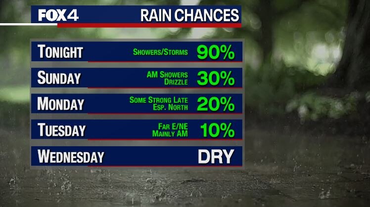
Cue the Ark! More rain this week....
We dry out today, but this pattern isn't done with us yet. Even though we will get warmer, we will stay wetter!
We dry out today, but this pattern isn't done with us yet. Even though we will get warmer, we will stay wetter!