


ONE April Day...next changes on the way!
After a cool start, Thursday will have a mild breezy finish in the 70s with sun. Then the cold front Friday is stronger. It will be cloudy with a few showers and temps in 50s all day.
After a cool start, Thursday will have a mild breezy finish in the 70s with sun. Then the cold front Friday is stronger. It will be cloudy with a few showers and temps in 50s all day.

April 15 overnight forecast
Dan Henry has the latest forecast.
Dan Henry has the latest forecast.

Temperatures on the rise heading into Thursday
It was a sunny Wednesday, and it's going to heat up on Thursday.
It was a sunny Wednesday, and it's going to heat up on Thursday.

Brief Warm Up
After a cold start, we'll see sun and light winds push us back into the 60s. Milder breezes and sun on Thursday will yield temperatures in the 70s. Then we could see a cold front Friday with more clouds, isolated showers and highs in the 60s.
After a cold start, we'll see sun and light winds push us back into the 60s. Milder breezes and sun on Thursday will yield temperatures in the 70s. Then we could see a cold front Friday with more clouds, isolated showers and highs in the 60s.

April 14 overnight forecast
Dan Henry has the latest forecast.
Dan Henry has the latest forecast.

April 14 afternoon forecast
Dan Henry has the latest forecast.
Dan Henry has the latest forecast.

Chill Lingers a Little Longer!
More clouds today plus a north wind keeps temps again in 50s. Clearing tonight will be coldest. Upper 30s BUT some patchy FROST. Milder Wed 60s, Warmer Thu 70s...a few showers Fri, with best rain/storm chances Sat PM-night.
More clouds today plus a north wind keeps temps again in 50s. Clearing tonight will be coldest. Upper 30s BUT some patchy FROST. Milder Wed 60s, Warmer Thu 70s...a few showers Fri, with best rain/storm chances Sat PM-night.

April 13 overnight forecast
Dan Henry has the latest forecast.
Dan Henry has the latest forecast.

April 13 evening forecast
Dan Henry has the latest forecast.
Dan Henry has the latest forecast.

A late winter chill... in spring
Stronger winds diminish today, highs only mid 50s. Near 40 tonight with more clouds (sprinkles) Tuesday. Only low-mid 50s. Patchy frost Wed AM, then back into 60s Wed, 70s Thu. Next cold front Friday (20% showers).
Stronger winds diminish today, highs only mid 50s. Near 40 tonight with more clouds (sprinkles) Tuesday. Only low-mid 50s. Patchy frost Wed AM, then back into 60s Wed, 70s Thu. Next cold front Friday (20% showers).

Storms Heading Out Of North Texas
The severe weather chances continue to go down as the storms move through North Texas
The severe weather chances continue to go down as the storms move through North Texas

Chance of Severe Weather on Easter
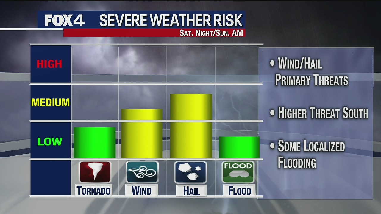
High wind and hail are the greatest risk as severe weather could hit North Texas overnight, into Easter morning.
High wind and hail are the greatest risk as severe weather could hit North Texas overnight, into Easter morning.

Chance of Severe Weather Overnight, into Sunday
There is a chance of severe weather overnight Saturday, into Easter Sunday.
There is a chance of severe weather overnight Saturday, into Easter Sunday.

April 10 overnight forecast
Dan Henry has the latest forecast.
Dan Henry has the latest forecast.
April 10 afternoon forecast
Dan Henry has the latest forecast.
Dan Henry has the latest forecast.

It's a GREAT Friday forecast!
Good Friday? No GREAT Friday! Weekend? Not as great. We'll see showers and storms Saturday with a few severe storms possible early Easter Sunday. After that, it dries out and is windy and mild in the 70s.
Good Friday? No GREAT Friday! Weekend? Not as great. We'll see showers and storms Saturday with a few severe storms possible early Easter Sunday. After that, it dries out and is windy and mild in the 70s.

April 9 overnight forecast
Dan Henry has the latest forecast.
Dan Henry has the latest forecast.

Chance of rain this weekend
There is a chance of rain on Easter Sunday.
There is a chance of rain on Easter Sunday.

Back to normal April
After yesterday's taste of summer, it's back to reality today. The highs will be in the mid 70s with a lot more cloud cover and a north wind.
After yesterday's taste of summer, it's back to reality today. The highs will be in the mid 70s with a lot more cloud cover and a north wind.

April 8 overnight forecast
Dan Henry has the latest forecast.
Dan Henry has the latest forecast.