


May 1 overnight forecast
Dan Henry has the latest forecast.
Dan Henry has the latest forecast.

May 1 afternoon forecast
Dan Henry has the latest forecast.
Dan Henry has the latest forecast.

May will start off hot
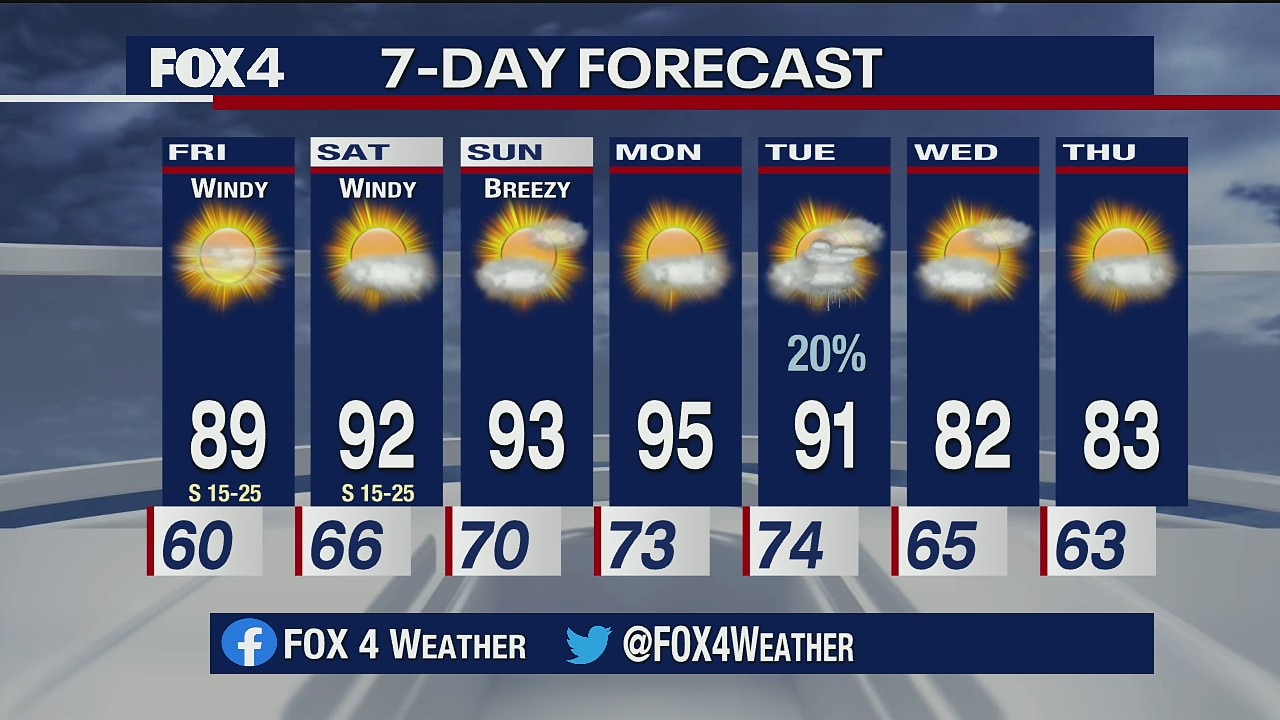
South winds crank up today with some high clouds and highs in the upper 80s. There will be more humidity and more clouds this weekend. It will be quite hot, in the low 90s. There's just a 20% chance of isolated showers Sunday.
South winds crank up today with some high clouds and highs in the upper 80s. There will be more humidity and more clouds this weekend. It will be quite hot, in the low 90s. There's just a 20% chance of isolated showers Sunday.

April 30 overnight forecast
Dan Henry has the latest forecast.
Dan Henry has the latest forecast.
Rising Temps This Weekend
Temperatures will be in the 90s across the Metroplex this weekend.
Temperatures will be in the 90s across the Metroplex this weekend.

Going from April to JUNE?! Where's May?
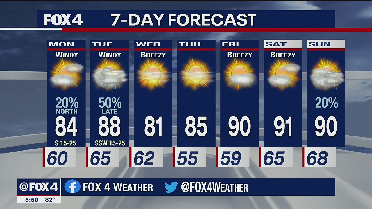
It will be absolutely beautiful today with sun, light winds, dry air and temperatures in the low 80s. But things will turn windy Friday and we could see highs in the 90s through the weekend. It'll be humid too.
It will be absolutely beautiful today with sun, light winds, dry air and temperatures in the low 80s. But things will turn windy Friday and we could see highs in the 90s through the weekend. It'll be humid too.

April 29 overnight forecast
Dan Henry has the latest forecast.
Dan Henry has the latest forecast.

April 29 afternoon forecast
Dan Henry has the latest forecast
Dan Henry has the latest forecast

Quieter end to April and a hot start to May
You'll see gusty north winds and drier air today as the sun takes over with temperatures in the upper 70s. But Meteorologist Evan Andrews says Thursday could be the nicest day of the week.
You'll see gusty north winds and drier air today as the sun takes over with temperatures in the upper 70s. But Meteorologist Evan Andrews says Thursday could be the nicest day of the week.

April 28 overnight forecast
Dan Henry has the latest forecast.
Dan Henry has the latest forecast.

April 28 afternoon forecast
Dan Henry has the latest forecast.
Dan Henry has the latest forecast.

Severe storms with damaging winds possible Tuesday night
Isolated storms bright hail to parts of North Texas early Tuesday morning. But Meteorologist Evan Andrews says the main event is Tuesday night.
Isolated storms bright hail to parts of North Texas early Tuesday morning. But Meteorologist Evan Andrews says the main event is Tuesday night.
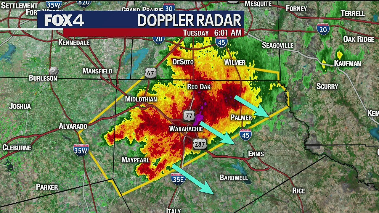
Early morning storms bring hail to parts of North Texas
Meteorologist Evan Andrews has an update on storms that have already produced large hail.
Meteorologist Evan Andrews has an update on storms that have already produced large hail.

Severe weather expected Tuesday night
Dan Henry has the latest forecast.
Dan Henry has the latest forecast.

April 27 afternoon forecast
Dan Henry has the latest forecast.
Dan Henry has the latest forecast.

One day for storms
This week we'll have just one day of storms. Otherwise, it's a nice end to April and a warm start to May.
This week we'll have just one day of storms. Otherwise, it's a nice end to April and a warm start to May.
Temperatures heating up
Temperatures will stay in the high 80s and 90s in the coming week.
Temperatures will stay in the high 80s and 90s in the coming week.

April 24 overnight forecast
Dan Henry has the latest forecast
Dan Henry has the latest forecast

Record high temperature at DFW for Friday
We tied a record high temperature at DFW Airport on Friday.
We tied a record high temperature at DFW Airport on Friday.

Winds of change for the last weekend in April
The forecast calls for gusty warm winds today with temperatures in the upper 80s. A cold front may trigger isolated evening storms east of Dallas. Saturday will be breezy and cooler in the mid-70s with some clouds. Sunday looks nice.
The forecast calls for gusty warm winds today with temperatures in the upper 80s. A cold front may trigger isolated evening storms east of Dallas. Saturday will be breezy and cooler in the mid-70s with some clouds. Sunday looks nice.