

'Paralyzing' lake-effect snowstorm expected to bury Buffalo, New York, under up to 3 feet of snow
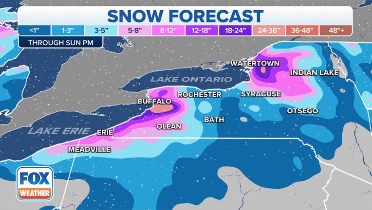
BUFFALO, N.Y. - A long-duration lake-effect snowstorm is expected to bury parts of western and northern New York, including the cities of Buffalo and Watertown, under up to 3 feet of snow into this weekend.
Bands of heavy snow are expected to develop to the east and northeast of lakes Erie and Ontario beginning Wednesday night and continuing right through Sunday, when the Buffalo Bills are scheduled to host the Cleveland Browns at Highmark Stadium in the Buffalo Southtowns.
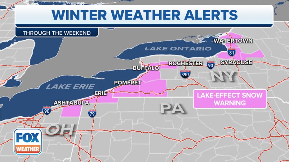
Lake-Effect Snow Warnings have been issued from the Buffalo metro area southwestward into northwestern Pennsylvania and northeastern Ohio on the east and northeast sides of Lake Erie, as well as from the Watertown metro area southward to the Tug Hill Plateau on the east end of Lake Ontario.
"This will be the start of a prolonged lake-effect snow event which will likely include paralyzing snowfall for the Buffalo and Watertown areas late this week through the weekend," the National Weather Service office in Buffalo wrote in its forecast discussion on Wednesday morning.
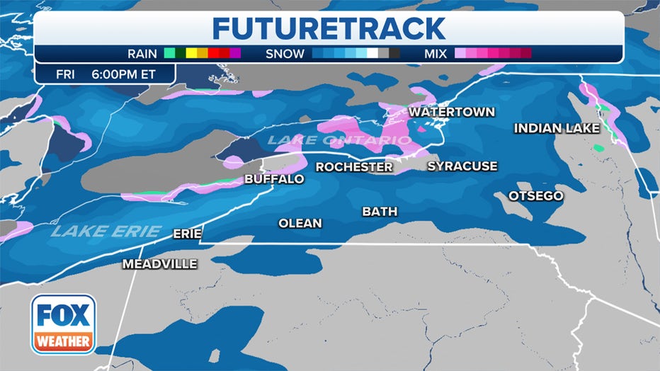
The lake-effect snow will start Wednesday night to the east of both lakes. The Lake Erie snow band will first set up south of Buffalo across the southern tier of western New York. The Lake Ontario snow band will be focused south of Watertown across the southern Tug Hill Plateau and may drop into the northern suburbs of Syracuse at times.
According to the FOX Forecast Center, snowfall rates of at least an inch per hour could lead to accumulations of 5 to 9 inches between Wednesday night and early Thursday. There could even be thundersnow within 10 to 15 miles of both lakeshores.
THUNDERSNOW: WHAT CAUSES LIGHTNING AND THUNDER DURING A SNOWSTORM?
During the day Thursday, bands of lake-effect snow will continue to drop an inch or more of snow per hour over many of the same areas as Wednesday night, including east of Lake Erie in the southern tier of western New York and east of Lake Ontario in areas north of Syracuse. An additional 3 to 7 inches is expected to pile up by sunset.
Then, the lake-effect bands are forecast to shift north and intensify Thursday evening when they will begin to threaten the Buffalo and Watertown metro areas and persist for an extended period of time.
"Crippling lake-effect snow storm possible this period," the NWS Buffalo office wrote in its short-term forecast discussion for Thursday night through Friday night.
The intense snow bands on the northeast ends of both lakes are not expected to oscillate much through at least Friday night and may set up directly over the Buffalo and Watertown metro areas during what the NWS called a "potential high-impact, long-duration lake snow event."
This weekend, both lake-effect snow bands will begin to oscillate north and south, bringing bursts of heavy snow into other areas outside the cities of Buffalo and Watertown.
BROWNS VS. BILLS IN BUFFALO: ‘POTENTIALLY HISTORIC’ SNOW FORECAST FOR SUNDAY'S WEEK 11 GAME
Snowfall rates in these bands have the potential to reach as high as 3 inches per hour, which means many towns will be measuring their snow in feet by the end of the weekend.
The FOX Forecast Center said the highest totals will likely be centered directly over the Buffalo and Watertown metro areas because of the nearly stationary bands of snow from Thursday night through Friday night. Between 1 and 3 feet of snow is expected to pile up by Sunday afternoon, with localized amounts of up to 4 feet not ruled out.
There could even be additional significant accumulations of snowfall to the northeast of both lakes early next week as cold winds continue to blow over the relatively warm waters of lakes Erie and Ontario.
BUFFALO BILLS' STADIUM IS OPEN TO MOTHER NATURE WITH LITTLE PROTECTION FROM IMPENDING SNOWSTORM
How does lake-effect snow form?
Lake-effect snow develops when cold, dry air, often originating from Canada, flows across the relatively warm waters of the Great Lakes.
As that cold air passes over the lakes, warmth and moisture from the water are picked up and transferred into the lowest portion of the Earth’s atmosphere. This rising air condenses into clouds, which can grow into narrow bands that are capable of producing snowfall rates as high as 2 to 3 inches per hour or more, according to the NWS.
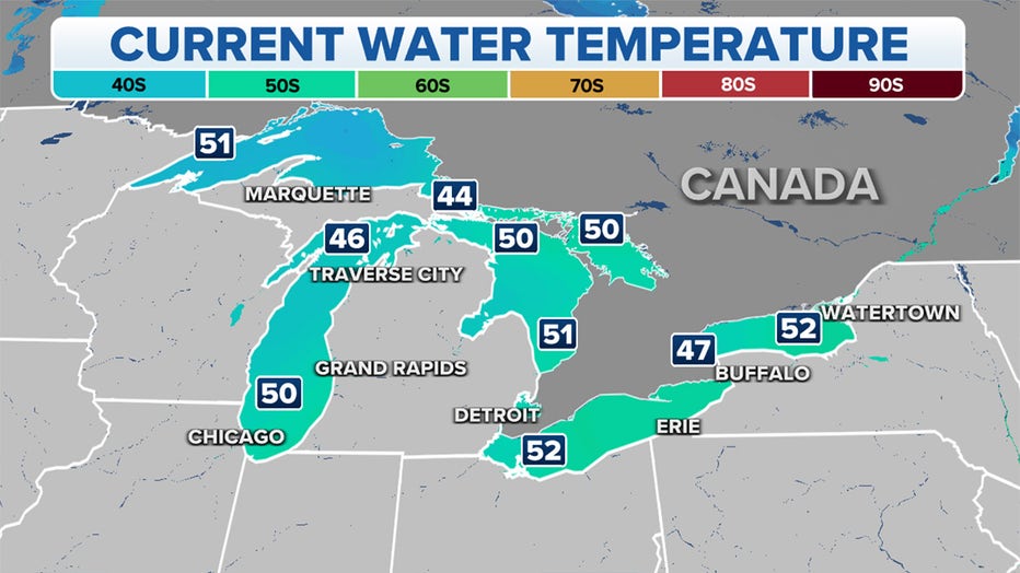
The temperatures of lakes Erie and Ontario currently range from the upper 40s to the lower 50s – much warmer than the temperatures in the 20s and 30s that are expected in western and northern New York during the upcoming lake-effect snowstorm.
This large temperature difference will create intense bands of snow off lakes Erie and Ontario through this weekend.
In fact, Lake Ontario's temperature is at its warmest value for mid-November in at least 27 years of recordkeeping, according to an analysis from NOAA's Great Lakes Environmental Research Laboratory. Lake Erie's temperature is at its second-warmest value for mid-November over the same period of record.
The Buffalo NWS office noted the weather pattern that will aid in producing this lake-effect snow event shares similarities with the historic November 2014 lake-effect storm that was dubbed "Snowvember."
More than 5 feet of snow crippled the Buffalo Southtowns, with South Cheektowaga tallying the most snowfall at 65 inches in just two days between Nov. 17-19, 2014.
Hundreds of major roof collapses and structural failures were reported, thousands of drivers were stranded, and there were scattered food and gas shortages due to impassable roads. Numerous trees also fell down due to the weight of the snow, causing isolated power outages where trees were toppled onto power lines.
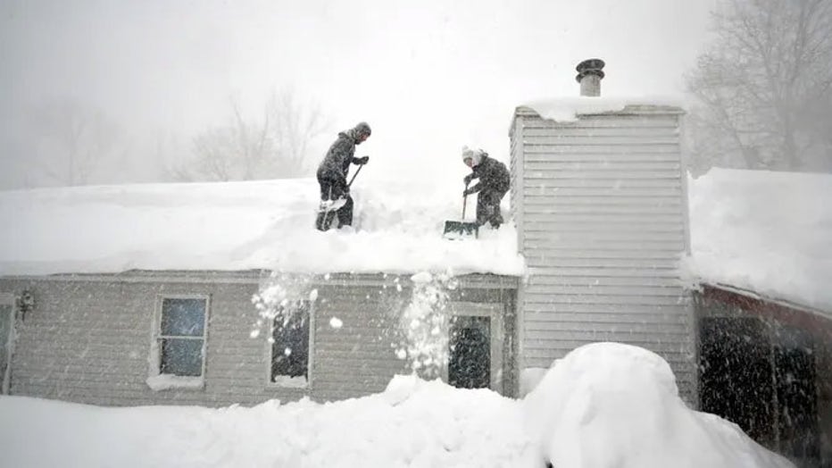
Tami Normile and Richard Brooks attempt to remove some of the 5 feet of snow from a rooftop on Nov. 20, 2014, in the Lakeview neighborhood of Buffalo, New York. (John Normile / Getty Images)
TOP 5 COSTLIEST SNOWSTORMS IN U.S. HISTORY
A 132-mile stretch of the New York State Thruway (Interstate 90) was shut down for several days from the Pennsylvania border to Rochester, New York. Other major routes, including Interstate 190, Interstate 290 and State Route 400, were also closed.
According to the NWS, this paralyzing lake-effect snowstorm was blamed for 14 deaths.
Buffalo is the 4th-snowiest city in the US
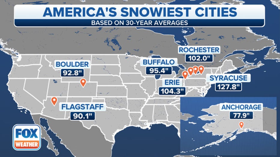
When looking at U.S. cities with a population of at least 50,000 residents, Buffalo ranks as the fourth snowiest in the nation. It averages 95.4 inches of snow each winter – just shy of 8 feet.
THESE ARE THE 7 SNOWIEST CITIES IN THE U.S.
Buffalo is the second-largest city in New York state, behind only New York City at the opposite end of the Empire State. It's located at the eastern end of Lake Erie, placing it in a prime spot for lake-effect snow off this Great Lake.
However, Buffalo does not typically receive as much snow as two other cities to its east, Rochester and Syracuse.
Rochester, some 70 miles east of Buffalo, averages 102 inches of snow each winter, while Syracuse – America's snowiest city – typically receives 127.8 inches of snow.