

Dallas Weather: Strong storms bring heavy rain, hail, flash flooding across North Texas

Storms bring heavy rain, hail, flash flooding
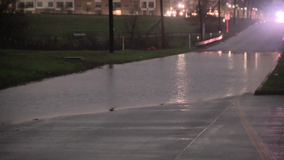
Multiple areas of North Texas dealt with flash flooding, hail and heavy rain from Thursday's storms. Several roads became impassable, but fortunately no serious injuries.
DALLAS - Multiple areas of North Texas dealt with flash flooding, hail and heavy rain from Thursday's storms.
Several roads became impassable, but fortunately no serious injuries.
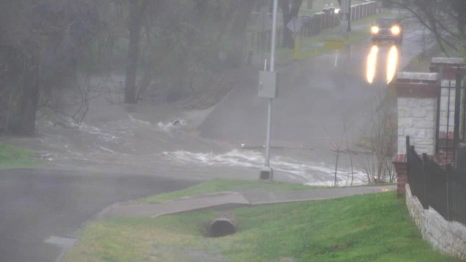
Flash flooding forced the closure of a portion of Kirkwood Boulevard in Southlake. A storm drain clogged, flooding the road and causing a car to stall out in the water.
There were similar scenes across the metroplex.

More: Dallas-Fort Worth Weather
The rainstorms started off slow and steady. But at the height of the evening rush hour, heavy rain brought many drivers to a standstill.
I-635 in Far North Dallas was blanketed in a wall of rain. Break lights illuminated the overcast skies.
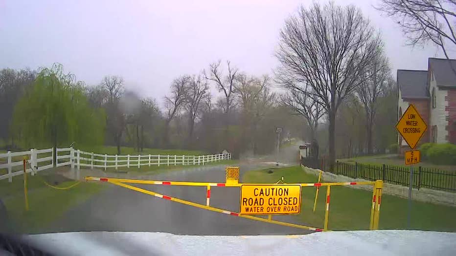
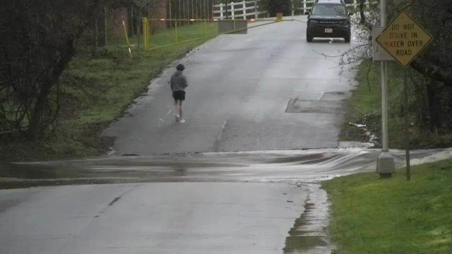
In Colleyville, a FOX 4 photojournalist came across a low water crossing at Cheshire Drive. The road was blocked off because of the swift water.
Colleyville police put out alerts about multiple flooded roads, including another one on Oak Knoll Drive. One person stopped to take pictures.
The unpredictable weather led the National Weather Service to issue a Flash Flood Warning for northern Dallas and northern Tarrant counties, but it also included Dallas, Fort Worth and Arlington.
Kurt Molhusen was sitting in his living room when he heard a loud boom outside his Irving home.
"There was wood all over the street. Some of it even made it almost all the way up to my door," he said.
Lightning had struck a tree in front of Molhusen’s neighbor’s house. He took photographs of the immediate aftermath.
"I walked over, and you could still smell the smoke," he recalled. "It burned it all the way down the middle."
City workers came out to remove the debris.
Luckily, no one was hurt.
The relentless rain caught many people off guard, including a woman whose car stalled in high waters off East Kirkwood Boulevard and Riviera Lane in Southlake.
Anil Kesani, the woman’s husband, was taking care of getting her car towed. He was thankful she's safe and is pretty understanding.

"She saw the water but then thought she could make it because she's used to driving an SUV," he said. "She's fine. She's good."
Both directions of Highway 377 in Keller were shut down because of flash flooding Thursday evening. The Marshall Ridge neighborhood and areas got around two inches of rain.
Live Radar

Hourly Updates
9:30 p.m
8:15 p.m
The Flash Flood Warnings have expired for Dallas and Tarrant counties, but some roadways could still see some flooding.
7:45 p.m.
Irving city workers came to clean up the mess after lightning struck a homeowner's tree.
7:30 p.m.
Dan Henry and Dylan Federico give an update on the latest timeline for severe weather.

Dallas Weather: March 7 7:00 p.m. update
Dan Henry and Dylan Federico have the latest on the severe weather chances.
6:27 p.m.
Look at this hail in Possum Kingdom!
6:15 p.m.
Kurt Molhusen from Irving shared photos of his tree that he says was struck by lightning.
6:10 p.m.
An update on our latest round of rain.
6:02 p.m.
The heaviest rain has moved out of Fort Worth and are now heading toward the mid-cities.
Our crews captured video of flooding in Colleyville.
5:55 p.m.
Brace yourself DFW! The next big soaker could be heading your way.
5:51 p.m.
Heavy rain has closed Hwy. 377 in both directions near the Marshall Ridge neighborhood.
5:50 p.m.
More flooding!
Colleyville police say Cheshire Drive, Oak Knoll Drive and Martin Parkway are closed due to high water.
5:38 p.m.
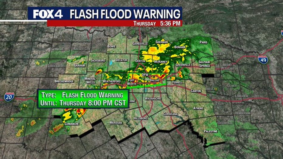
A Flash Flood Warning has been issued in Dallas and Tarrant Counties until 8 p.m.
5:29 p.m.

Hail falls in Palo Pinto Co.
FOX 4 viewer Jerry Lampier posted video of hail in his backyard in Palo Pinto County on March 7, 2024.
Viewers in Palo Pinto County posted video of hail falling in their backyard.
The hail is from the severe thunderstorm in the area.
5:22 p.m.
In addition to all the rain, we are also seeing lightning across the area.
This tree was struck earlier today.
5:17 p.m.
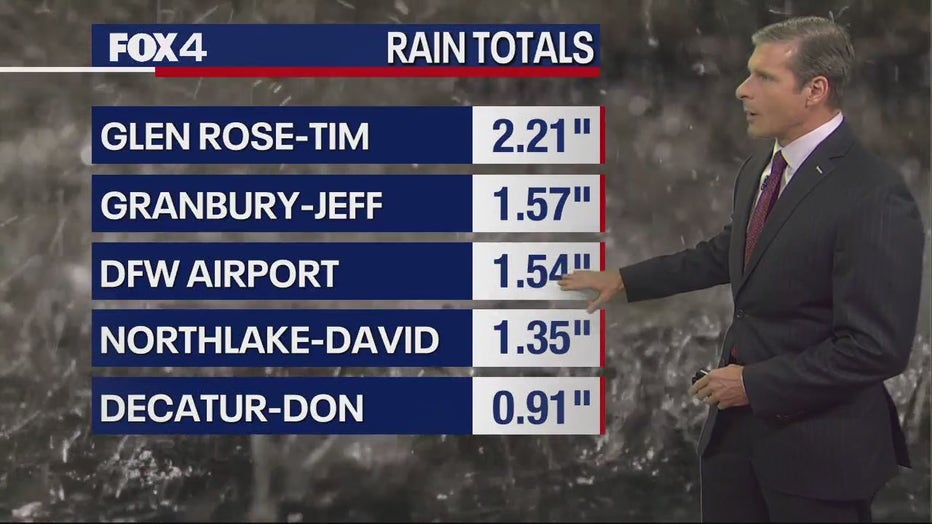
We have already seen record rainfall at Dallas-Fort Worth Airport for March 7.
We are at 1.54 inches and more is expected to fall.
5:07 p.m.
FOX 4 viewer Erin Ford in Salesville, Texas, north of Mineral Wells, shared photos of flooding in the area.
The storms in northern Palo Pinto county will push into southern Jack and NW Parker counties over the next hour.
Some pocket change-sized hail as been spotted in the area.
5:01 p.m.
Severe Thunderstorm Warnings are being issued as the storm moves into the Metroplex.
4:49 p.m.
Ground stops were issued at DFW Airport and Dallas Love Field due to thunderstorms. More than 400 flights have been delayed from DFW.
4:16 p.m.
A Flood Advisory is in effort from Dallas and Fort Worth north into southern Denton and Collin counties.
3:04 p.m.
A Severe Thunderstorm Watch was issued for western counties until 10 p.m.
2 p.m.
Heavy rains in the northwest portion of North Texas led to a flash flood warning being issued until 4 p.m.
A few inches of rain had already fallen at 2 p.m. and 1 to 2 more inches could be possible.
Original Story
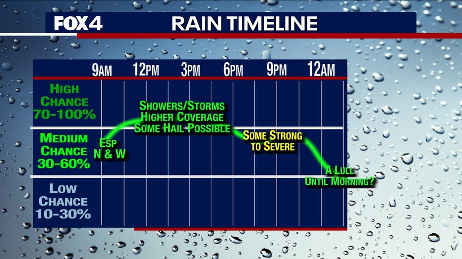
The strongest storms are expected in the evening and again on Friday morning.
They have the potential to bring hail, flooding rain, and gusty winds.
"Mainly some hail, which is good. We don’t see that high a weather risk," Evan said. "Maybe tomorrow between like 4 and 8 a.m. there could be another batch of storms with a wind and hail risk. East Texas could have a little stronger storm out of this and could have even a little tornado threat."
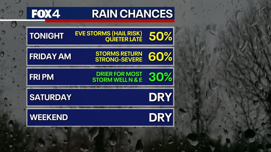
The storms will move east Friday morning for a dry and slightly cooler weekend.
High temperatures will be in the 60s on Saturday and Sunday, with lows in the upper 30s and 40s.
7-Day Forecast
