

Dallas weather: Summer approaches with storm chances Wednesday, 100+ heat index
DALLAS - North Texas can expect a final round of scattered storms today before officially transitioning into the summer season next week. North Texas will continue to experience hot and humid conditions throughout the week.
Wednesday Forecast: Gusty Winds and Hail Risk Possible

Dallas weather: June 18 morning forecast
Rain chances return to Dallas-Fort Worth today. Meteorologist Evan Andrews has your forecast and storm timing.
More clouds are expected today, but the heat and humidity isn't going anywhere. Low rain chances are possible this morning in areas west and north of the Metroplex.
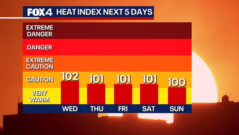
As clouds break, temperatures will climb into the 90s this afternoon, with dewpoints of at least 70 degrees, pushing the heat index over 100 degrees. Storms may develop Wednesday evening, primarily between 7 p.m. and midnight, bringing gusty winds and some hail risk. The highest storm coverage is expected north of DFW, and storms should diminish overnight.
Live Weather Radar

Thursday Forecast: Slight Rain Chances Continue
A stalled front near the Red River will keep moisture in the Metroplex on Thursday. Humid conditions will continue with low, 20% chances of storms. Winds on Thursday are expected to be lighter.
7-Day Forecast

Summer officially begins Friday, bringing hotter temperatures. Highs will remain in the mid-90s under partly to mostly sunny skies.
Next week and throughout the weekend, breezy and humid conditions are expected, with seasonal summer temperatures in the mid-90s.
The Source: Information in this article comes from the National Weather Service and meteorologist Evan Andrews.