

Enjoy the Warmth,..it's about to change!
Near 80 today but a cold front tonight will drop temps and increase rain chances starting tomorrow and continuing mid-week.
Near 80 today but a cold front tonight will drop temps and increase rain chances starting tomorrow and continuing mid-week.

Briefly Spring, then Rainy and Cool!
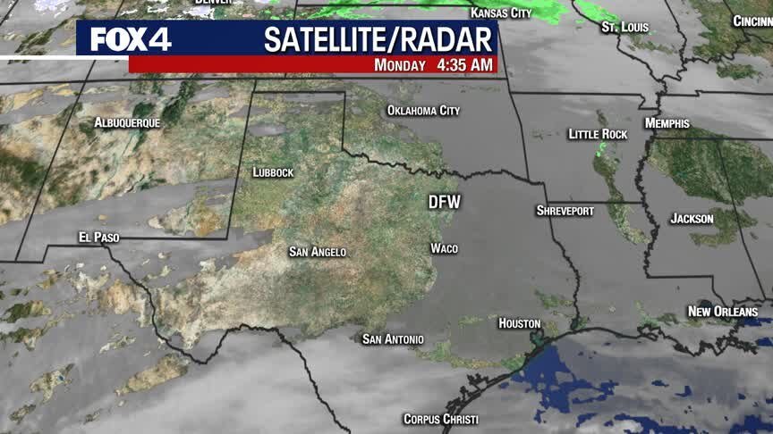
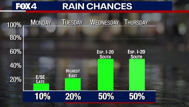
Spring to start the work week, then we drop back to reality! A cold front moves through Monday evening with little fan-fare. By mid-week, a couple of disturbances return rain chances, with highest coverage south of I-20.
Spring to start the work week, then we drop back to reality! A cold front moves through Monday evening with little fan-fare. By mid-week, a couple of disturbances return rain chances, with highest coverage south of I-20.

Feeling Like Spring!
Highs expected in the 70s today, with plenty of sunshine. Even warmer tomorrow, before cooler conditions return & rain chances increase midweek.
Highs expected in the 70s today, with plenty of sunshine. Even warmer tomorrow, before cooler conditions return & rain chances increase midweek.
Roller Coaster Continues!
Southwesterly winds continue the warming trend to end the weekend. President's Day will be the warmest of the week, with temperatures climbing into the upper 70s ahead of a cold front. Rain chances slowly increase, with several disturbances moving through the middle of the week.
Southwesterly winds continue the warming trend to end the weekend. President's Day will be the warmest of the week, with temperatures climbing into the upper 70s ahead of a cold front. Rain chances slowly increase, with several disturbances moving through the middle of the week.

Beautiful Weekend Forecast!
Chilly this morning, with highs soaring into the 60s this afternoon. 70s Sunday & Monday before we plunge, thanks to another strong cold front.
Chilly this morning, with highs soaring into the 60s this afternoon. 70s Sunday & Monday before we plunge, thanks to another strong cold front.

Friday Noon Update
Here's your Valentine's afternoon/evening forecast!
Here's your Valentine's afternoon/evening forecast!
Only UP from here!
From Freezing to temps near 80! Ok, it will take the next few days, but we are headed UP until next Tuesday, when we rapidly head back DOWN!
From Freezing to temps near 80! Ok, it will take the next few days, but we are headed UP until next Tuesday, when we rapidly head back DOWN!
Chilly Start To Thursday!
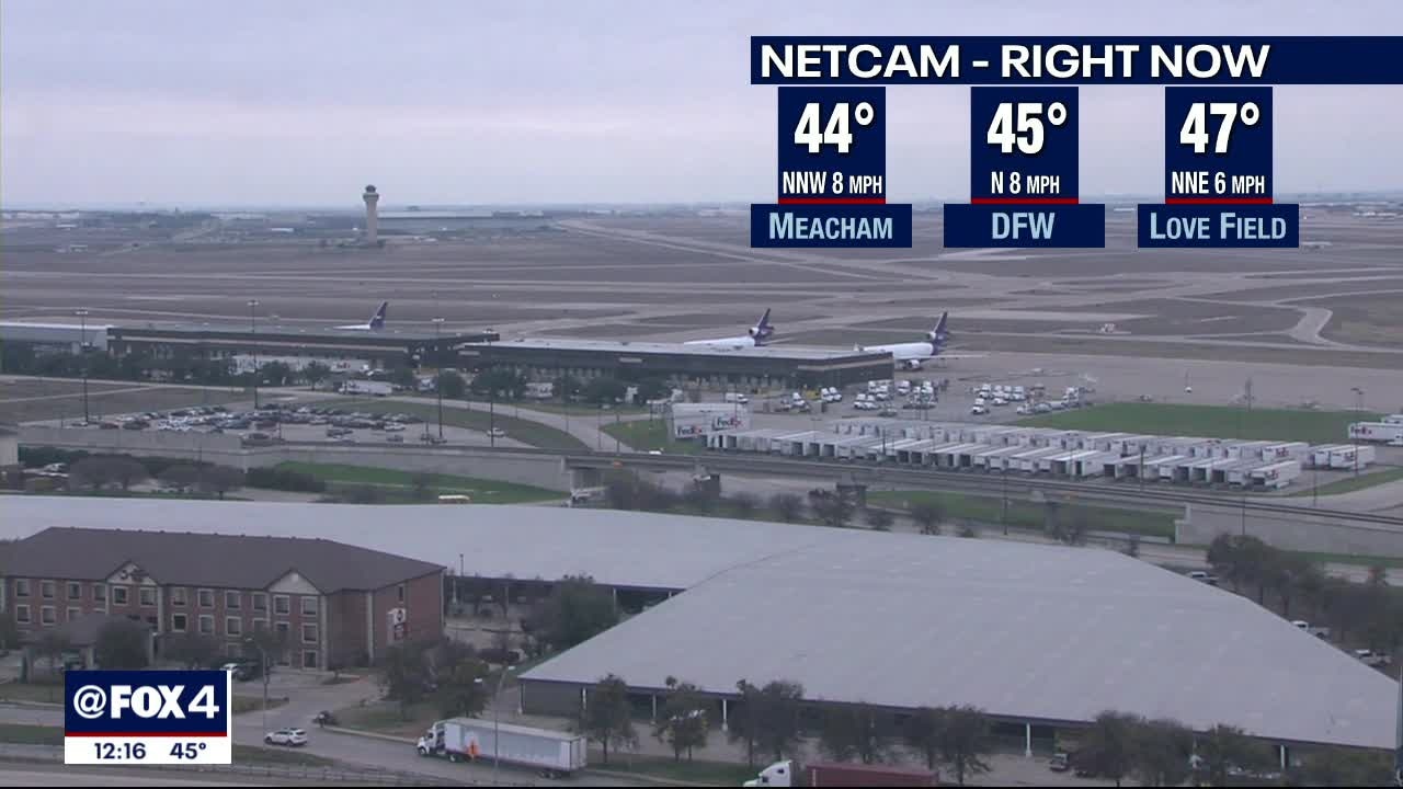
Wind chills in the 20s and 30s this morning, with a little bit more cloud cover. Sunshine this afternoon, with highs expected in the 40s!
Wind chills in the 20s and 30s this morning, with a little bit more cloud cover. Sunshine this afternoon, with highs expected in the 40s!
Rain Gone, Chill Temps Stay
It will be a heavy jacket kind of morning with the wind chill values for many in the low to mid 20s to start your Thursday. The good news is that the rain is gone, and the morning clouds will give away to better sunshine chances by Thursday afternoon. The even better news, 60s and near 70s expected for the weekend. Make the most of life!
It will be a heavy jacket kind of morning with the wind chill values for many in the low to mid 20s to start your Thursday. The good news is that the rain is gone, and the morning clouds will give away to better sunshine chances by Thursday afternoon. The even better news, 60s and near 70s expected for the weekend. Make the most of life!

Wet Morning Commute
Allow for extra time on your commute this morning! Roads are wet, and rain will continue through mid-morning. A few peeks of sunshine return this afternoon, with highs in the upper 40s and low 50s.
Allow for extra time on your commute this morning! Roads are wet, and rain will continue through mid-morning. A few peeks of sunshine return this afternoon, with highs in the upper 40s and low 50s.

One More Round!
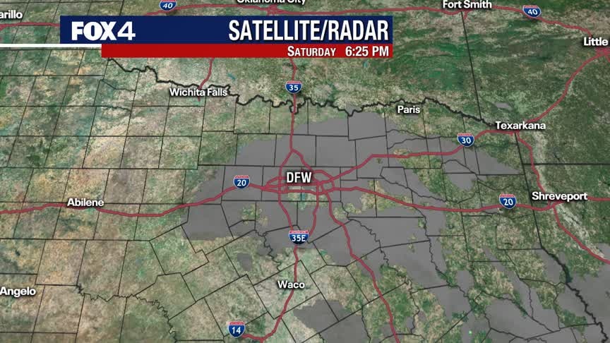
The last disturbance moves through overnight into Wednesday. Expect widespread rain and isolated storms through the morning commute. By Wednesday afternoon, North Texas dries out from west to east. We briefly dry out and slowly warm up to end the week and head into the weekend. Unsettled weather returns next week.
The last disturbance moves through overnight into Wednesday. Expect widespread rain and isolated storms through the morning commute. By Wednesday afternoon, North Texas dries out from west to east. We briefly dry out and slowly warm up to end the week and head into the weekend. Unsettled weather returns next week.

A Few more Rounds of RAIN!
On and off showers (and a few rumbles) today with widespread RAIN late tonight into Wednesday morning....then it's OUTTA here! A drier end of the week on the way.
On and off showers (and a few rumbles) today with widespread RAIN late tonight into Wednesday morning....then it's OUTTA here! A drier end of the week on the way.

Chilly & Wet!
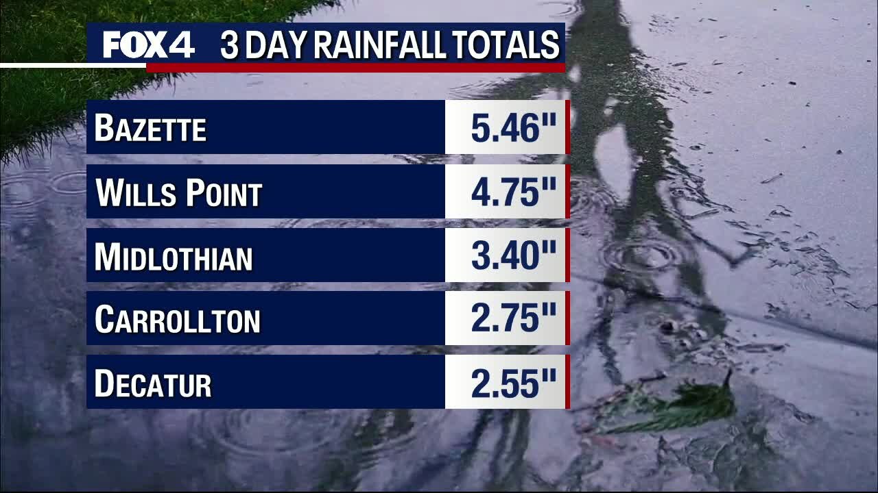
One disturbance exits this evening, but there are a couple more on the way! Widespread rain and storms move in again early Tuesday, with another round Tuesday night into Wednesday. Several inches of rain are expected, with the highest totals for areas SE of DFW. We dry out briefly and slowly warm up to end the week.
One disturbance exits this evening, but there are a couple more on the way! Widespread rain and storms move in again early Tuesday, with another round Tuesday night into Wednesday. Several inches of rain are expected, with the highest totals for areas SE of DFW. We dry out briefly and slowly warm up to end the week.
Wet Week
Showers and embedded storms will roll through DFW late this afternoon and into the evening hours. Just in time to leave us with a wet commute home from work. Temperatures will remain chill through most of the week with more rounds of rain expected through at least Wednesday afternoon. Here's the good news, 60s and dry for the weekend!
Showers and embedded storms will roll through DFW late this afternoon and into the evening hours. Just in time to leave us with a wet commute home from work. Temperatures will remain chill through most of the week with more rounds of rain expected through at least Wednesday afternoon. Here's the good news, 60s and dry for the weekend!

Chilly....and WET weather on the way!
At least three more rounds headed in...the first later today, the second tomorrow, and the third (heaviest) Tuesday night into Wednesday AM
At least three more rounds headed in...the first later today, the second tomorrow, and the third (heaviest) Tuesday night into Wednesday AM

Chilly & Wet Start to the Week!
Scattered showers and potentially a few strong storms are expected tonight as a cold front moves through North Texas. Behind the front, north winds usher in much cooler air. The weather pattern stays active, with several rounds of rain expected through Wednesday. We briefly dry out and warm up to end the work week. By the weekend, small rain chances return.
Scattered showers and potentially a few strong storms are expected tonight as a cold front moves through North Texas. Behind the front, north winds usher in much cooler air. The weather pattern stays active, with several rounds of rain expected through Wednesday. We briefly dry out and warm up to end the work week. By the weekend, small rain chances return.
Storm Chances Today
Keep the umbrella handy today! Showers/storms return later this afternoon & evening. Some could be strong.
Keep the umbrella handy today! Showers/storms return later this afternoon & evening. Some could be strong.

Rain Returns!
Strong southerly winds keep temperatures mild Sunday, but showers and a few storms return as well, thanks to a cold front. The weather pattern stays unsettled and much cooler heading into next week. We dry out and slowly warm up to end the work week.
Strong southerly winds keep temperatures mild Sunday, but showers and a few storms return as well, thanks to a cold front. The weather pattern stays unsettled and much cooler heading into next week. We dry out and slowly warm up to end the work week.

Thawing Out Today!
We'll warm into the 60s today, with plenty of sunshine. Clouds & humidity (as well as rain chances...) return tomorrow!
We'll warm into the 60s today, with plenty of sunshine. Clouds & humidity (as well as rain chances...) return tomorrow!

Mild Weekend
A few high clouds and chilly overnight with lows in the 30s. Partly to mostly sunny on Saturday with a high of 61?. Rain chances return late Sunday.
A few high clouds and chilly overnight with lows in the 30s. Partly to mostly sunny on Saturday with a high of 61?. Rain chances return late Sunday.