

Dallas Weather: How much snow did Dallas get? Snow totals, power outages and dangerous -12° wind chill
DALLAS - Many in North Texas woke up to significantly more "white stuff" on the ground this morning… and the winter event isn't quite over.
Light snow and a sleet mix to the east will linger through the early hours, likely exiting near sunrise. However, as strong northwest winds blow cold air across area lakes, lake-effect snow is expected. This may result in scattered flurries and localized accumulations in snow bands downwind of area lakes.
Texas Winter Storm

Dallas Weather: Jan. 25 noon forecast
FOX 4 Weather Meteorologist Berkeley Taylor talks about the end of the sleet and snow and the beginning of the extreme cold.
According to the National Weather Service, a Winter Storm Warning for North and Central Texas has now expired. Now, there's just an Extreme Cold Warning in effect through Tuesday morning.
If you lose power, you can still stream FOX LOCAL on our mobile app: DOWNLOAD HERE
Sunday Weather Forecast

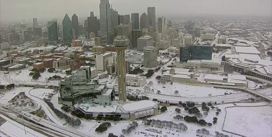
The Dallas-Fort Worth area is bracing for a historic cold snap this morning. After a mix of sleet and snow, temperatures are expected to hover around 13 degrees through the morning. While sleet is transitioning to snow across North Texas, flurries may continue through the afternoon with an expected high of only 19 degrees. If realized, this would set a new record for the lowest high temperature ever recorded on Jan. 25.
Lingering Flurries and "Lake-Effect" Snow
While the most organized precipitation has exited the region, light snow continues to linger in northern counties. Sleet accumulations have averaged 1 to 2 inches in DFW, with higher totals reported to the north.
Strong northwest winds are creating a unique phenomenon: lake-effect snow. The relatively warm water of area lakes is providing enough moisture for narrow bands of snow to develop downwind (southeast) of the lakes. While most will only see flying flakes, these narrow bands could cause localized accumulations.
Dangerous Temperatures
Temperatures will remain below freezing through early Tuesday. Overnight, lows are expected to drop into the single digits, reaching 9 degrees. This would break the standing record low of 12. In areas with deeper snow cover to the north, temperatures could approach zero.
Read More:
- LIVE UPDATES: Winter storm road conditions, power outages, school closings in North Texas
- Dallas winter storm: Power outages Saturday
- North Texas school districts canceling class on Monday: LIST
Monday Weather Forecast

Photos by Kyrstain Clark w/ Clark Contracts LLC in Weatherford
Monday is shaping up to be another record-breaking day. The morning will begin with a low of 9 degrees, and afternoon highs are only expected to reach 28 degrees.
The "feels-like" temperatures will be particularly brutal, sitting at minus 5 degrees Monday morning. While skies will turn partly sunny, the region will remain below freezing. The sunshine and road treatments will aid in some melting on main highways, but motorists should be wary of black ice as surfaces will refreeze rapidly after sunset.
Tuesday Forecast
By Tuesday afternoon, the region is expected to finally climb above freezing after roughly 80 consecutive hours of sub-freezing temperatures. Tuesday morning will start near the record low of 11 degrees, but shifting southwest winds will help push afternoon highs toward 40 degrees. A dry cold front will approach Tuesday evening, bringing clouds but no additional precipitation.
Sleet & Snow Predictions

Most of the Dallas-Fort Worth area received 1 to 2 inches of accumulation, consisting primarily of sleet. Areas north of the metroplex saw higher totals of 3 to 5 inches of a snow and sleet mix, while areas to the south reported around 1 inch.
What is sleet?
Sleet is frozen rain that forms when snow partially melts and then re-freezes into ice pellets before hitting the ground. It is known for "bouncing" on impact, according to NWS.
Dallas Road Conditions
While precipitation ends today, travel will remain hazardous into Monday. Accumulating ice and sleet have significantly degraded road conditions across the region, according to NWS. Officials advise residents to stay home and stay warm. Do not travel unless absolutely necessary. For the latest road updates, check with the Texas Department of Transportation.
LIVE UPDATES: Winter storm road conditions, power outages, school closings in North Texas
With a Winter Storm Warning in effect, FOX 4 is bringing you live, minute-by-minute updates on North Texas temperatures, ice and snow totals, road conditions, flight cancellations, closings, and more.
Closings & Cancellations
Most North Texas school districts have decided to close school on Monday. There are also events, activities, and church services that have been canceled over the weekend.
LIVE: North Texas school closings Monday; Full list of DFW districts closed for Winter Storm Fern
FOX 4 is tracking the organizations who are calling off school, events and more due to the weather.
Power Outages
As winter weather moves through Texas, power outages in the state have topped 50,000, but the Electric Reliability Council of Texas' grid has remained stable with sufficient power reserves.

Dallas winter storm: Power outages Sunday
Oncor is reporting power outages in North Texas as the winter storm continues.
7-Day Forecast

LIVE RADAR: Dallas-Fort Worth

Send Us Your Photos
The Source: Information in this article comes from the National Weather Service, FOX 4 meteorologists, Texas officials and FOX 4 reporting.