

Dallas weather: Prepare for severe storms with strong, gusty winds and hail

Tuesday Forecast
DALLAS - North Texas stayed dry for the most part Monday, but the main event is overnight into Tuesday morning.
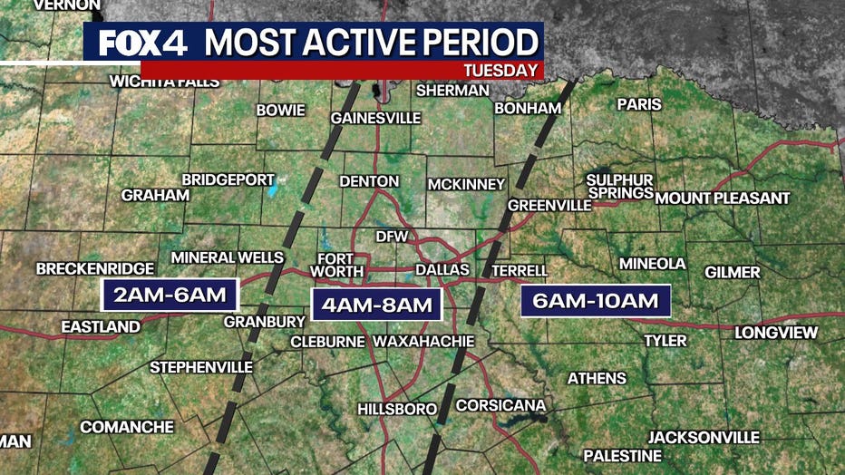
It still looks like a 2 a.m. – 10 a.m. event (4-8 a.m. for the I-35 corridor including the Metroplex).
A very vigorous upper-level system will likely set off a line of storms along a Pacific cold front. Initial storms will move into western areas after 3 a.m. and race through at 50 mph. So, this will be a fast event. High winds, up to 60 mph, are the main severe weather risk in the strongest storms. Since it is a line, there's always the risk of a brief spin up on the leading edge. Hail risk is there but not a huge concern at the moment.

Later in the morning into early afternoon, it will turn mainly sunny and very windy. WSW winds could gust to 40-45 mph as very dry air races in, and temps rebound into the low 70s. We could see dust blow as well.
A second cold front sweeps through late day, so winds will shift again along with a few clouds. By Wednesday morning, we'll be in the 40s with a bit of a wind chill too.
Wednesday & Thursday Forecast
Wednesday will be SUNNY and cool with highs near 60. Diminishing winds will make for a nice early March afternoon.
After a chilly start on Thursday, we'll rebound into the 60s as south winds start to increase. Sunday will yield to some afternoon cloudiness but otherwise fairly quiet.
DOWNLOAD THE FOX 4 WEATHER APP
Friday into the weekend
Friday will see another SHIFT in the winds. Clouds in the morning will turn to sun as winds become westerly and temps should jump back into the 70s. Fairly warm end to the week.
Ready for another big change? That happens on Saturday. A cold front Friday night will cool us down. At the same time, an upper-level system will race across Texas from the west. That means mainly cloudy skies and a chance for a few showers. With a north wind, we'll struggle to get out of the 50s in most areas.
That system exits on Saturday night as we turn the clocks forward. By Sunday morning, we'll have lows in the 30s and even a light freeze possible in northern areas before sunshine helps push us back into the 60s.
7-Day Forecast

The Source: Information in this article is from FOX 4's Meteorologist Evan Andrews.