

Dallas weather: Tornado watch follows North Texas' overnight severe weather
Deadly tornadoes and severe thunderstorms leave 2 dead
Following a night of deadly tornadoes and 90 mph winds, Texas remains under a weather alert for Sunday, with a conditional risk for isolated severe storms capable of producing 2+ inch hail.
DALLAS - Severe storms that swept across North Texas overnight left behind large hail, damaging winds and confirmed tornadoes, with attention now turning to a lower, but still possible, risk for additional storms Sunday evening into the night.
Sunday conditions
What we know:
By Sunday afternoon, conditions across North Texas turned warm and humid, with temperatures climbing into the upper 80s to near 90 degrees.
While the atmosphere still contains energy for storms, forecasters say conditions are less favorable than Saturday, thanks to a stronger cap and slightly lower instability. Forecasters are now monitoring the potential for isolated strong to severe storms Sunday evening, mainly across northwestern North Texas.

Dig deeper:
The overall threat is lower than Saturday’s outbreak, but not zero. If storms develop, the main threats include:
- Large hail (potentially up to baseball size)
- Damaging winds of 60–65 mph
- An isolated tornado, especially after sunset
FOX 4 weather team emphasizes that while a Saturday night is unlikely, any storm that forms could quickly become severe due to lingering wind shear in the atmosphere.
Tornado Watch
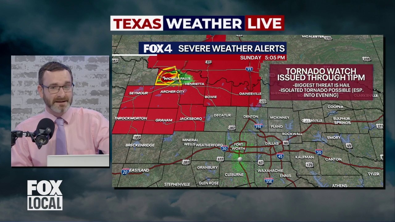
DFW Weather: Tornado watch issued for Sunday
A tornado watch was issued for parts of North Texas on Sunday night. It comes just a night after tornadoes touched down in Parker and Wise Counties. Meteorologist Josh Johns breaks down what to expect tonight and what made last night's storms different from others.
A tornado watch is in effect for Cooke County, Jack County, Montague County and Young County until 11:00 p.m.
Storm development is expected to remain isolated, with the greatest chance focused northwest of the Metroplex.
Any storms that form will likely move slowly and could persist into the evening hours before weakening. Most activity is expected to diminish by 10 to 11 p.m., when the tornado watch expires.
Saturday night weather in North Texas
The backstory:
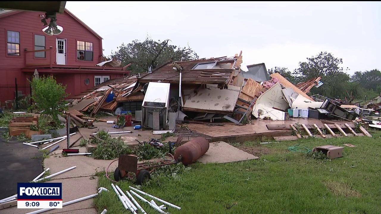
The strongest storms moved through late Saturday night into early Sunday morning, producing widespread damage across North Texas. Areas including Arlington, Duncanville and Fort Worth reported significant hail, with some stones reaching about 1.5 inches in diameter, along with destructive wind gusts.
A powerful, long-lived supercell tracked across multiple counties, intensifying as it moved southeast into the Dallas-Fort Worth area and creating a dangerous combination of large hail, damaging winds and tornadoes.
EF-2 tornado confirmed in Runaway Bay on Saturday
The National Weather Service confirmed at least two tornadoes from Saturday night’s storms:
- An EF-2 tornado in Wise County near Runaway Bay, with peak winds around 130–135 mph and a path roughly 1.4 miles long
- An EF-1 tornado in Parker County near Springtown, which remained on the ground for nearly 10 miles

North Texas tornadoes officially confirmed from Wise and Parker Counties on Saturday night
The National Weather Service confirmed that two deadly tornadoes caused significant destruction and multiple fatalities across Wise and Parker counties during a night of severe storms in North Texas.
Both tornadoes caused significant damage, and officials confirmed two fatalities, one in each area.
Survey teams say additional tornadoes are possible along the storm’s path, with more assessments expected in the coming days.
Live Radar: Potential for tennis ball sized hail

By Sunday afternoon, conditions across North Texas turned warm and humid, with temperatures climbing into the upper 80s to near 90 degrees.
While the atmosphere still contains energy for storms, forecasters say conditions are less favorable than Saturday, thanks to a stronger cap and slightly lower instability.
7-Day Forecast

Rain chances remain in the forecast through the upcoming week, with a better opportunity for scattered storms returning Tuesday.
A cold front later in the week is expected to bring cooler temperatures, with highs falling from the 90s into the 80s and eventually the upper 60s.
Download the WAPP

Residents are urged to "stay weather-aware" for the next two days, particularly late Sunday night and throughout Monday, and to ensure they have a way to receive weather warnings.
The Source: Information in this article comes from the FOX 4 weather team.