


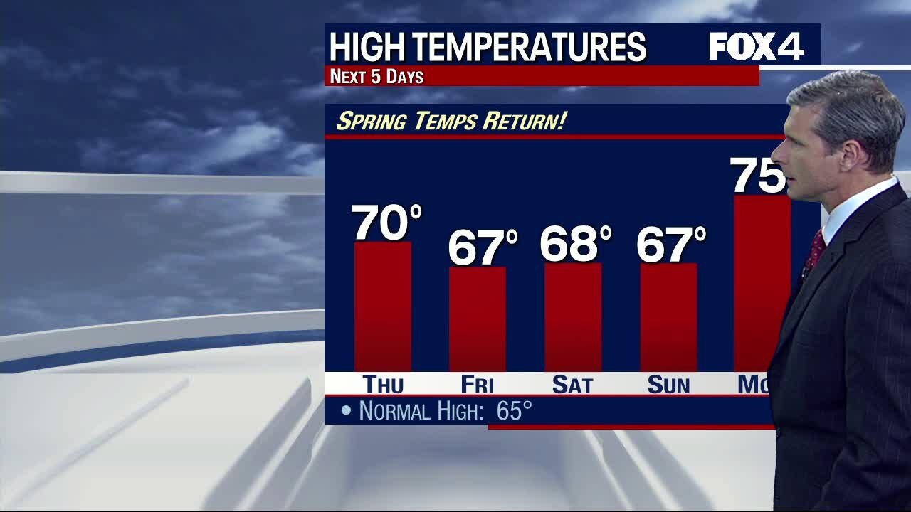
Nice and Easy
A bit chilly overnight with lows in the upper 30s to lower 40s. Lots of sun on tap for Friday with highs in the mid 60s. Breezy/mild for the weekend. More clouds roll in, but our next round of scattered showers holds off until late Sunday.
A bit chilly overnight with lows in the upper 30s to lower 40s. Lots of sun on tap for Friday with highs in the mid 60s. Breezy/mild for the weekend. More clouds roll in, but our next round of scattered showers holds off until late Sunday.

Thursday Afternoon Forecast
A gorgeous afternoon is in store for us! Here's a sneak peek.
A gorgeous afternoon is in store for us! Here's a sneak peek.

Cool Start, Nice Finish!
Clouds moved out overnight, and we're looking at plenty of sunshine this morning. Temperatures are on the cooler side, but we'll top out near 70 this afternoon. Enjoy your day!
Clouds moved out overnight, and we're looking at plenty of sunshine this morning. Temperatures are on the cooler side, but we'll top out near 70 this afternoon. Enjoy your day!
Last Round Moves Out
Widespread rain will continue late into the night, but quickly come to an end around midnight. Some morning clouds will hang out eventually giving way to a lot of sunshine. Temperatures will be rebound yet again and we will usher in the weekend with good weather.
Widespread rain will continue late into the night, but quickly come to an end around midnight. Some morning clouds will hang out eventually giving way to a lot of sunshine. Temperatures will be rebound yet again and we will usher in the weekend with good weather.

Wednesday Afternoon Forecast
Here's a look at your afternoon/evening forecast. We'll dry out briefly, before another round of showers moves through!
Here's a look at your afternoon/evening forecast. We'll dry out briefly, before another round of showers moves through!

Wet Wednesday!
Showers and storms are widespread this morning. Parts of north Texas will see a break this afternoon. Here's your Wednesday forecast!
Showers and storms are widespread this morning. Parts of north Texas will see a break this afternoon. Here's your Wednesday forecast!

Rain & Storms Return!
The next disturbance brings widespread rain and storms beginning overnight and through Wednesday. Heaviest rain and strongest storms are expected south of I-20. Gusty winds and hail will be possible.Once this system exits, expect sunshine and mild temperatures to end the week.
The next disturbance brings widespread rain and storms beginning overnight and through Wednesday. Heaviest rain and strongest storms are expected south of I-20. Gusty winds and hail will be possible.Once this system exits, expect sunshine and mild temperatures to end the week.

Wet Morning Commute
Widespread rain tonight through much of Wednesday might lead to some trouble for your Wednesday AM & PM commute. Allow some additional time for your commute. Drier and warmer conditions return on Thursday.
Widespread rain tonight through much of Wednesday might lead to some trouble for your Wednesday AM & PM commute. Allow some additional time for your commute. Drier and warmer conditions return on Thursday.

Heavy Rain Returns!
A weak cold front slides through North Texas today. Low rain chances exist with the frontal passage. Better rain chances return Tuesday night into Wednesday, as a strong disturbance moves across the state. Widespread heavy rain and a few strong storms are expected. Once this system exits, sunshine and mild temperatures are left behind.
A weak cold front slides through North Texas today. Low rain chances exist with the frontal passage. Better rain chances return Tuesday night into Wednesday, as a strong disturbance moves across the state. Widespread heavy rain and a few strong storms are expected. Once this system exits, sunshine and mild temperatures are left behind.
Mild, Muggy With Widespread Rain To Come
A muggy start to the week with temperatures once again climbing into the mid 70s for many of us. Isolated showers this afternoon for areas to the east of DFW, but promising rain chances will overcome most of North Texas Tuesday night through much of Wednesday. Sunshine returns Thursday!
A muggy start to the week with temperatures once again climbing into the mid 70s for many of us. Isolated showers this afternoon for areas to the east of DFW, but promising rain chances will overcome most of North Texas Tuesday night through much of Wednesday. Sunshine returns Thursday!

Rain Returns!
Big changes on the way thanks to a cold front! Expect heaviest rainfall Tuesday night into Wednesday. A few storms may produce gusty winds, but severe weather is not anticipated.
Big changes on the way thanks to a cold front! Expect heaviest rainfall Tuesday night into Wednesday. A few storms may produce gusty winds, but severe weather is not anticipated.
Warm End To The Weekend!
Winds will stay strong today, helping temps climb well into the 70s. A cold front tomorrow will bring better rain/storm chances through midweek.
Winds will stay strong today, helping temps climb well into the 70s. A cold front tomorrow will bring better rain/storm chances through midweek.

Rain Chances Return!
Strong southerly winds keep temperatures well above normal across North Texas ahead of our next cold front. The front stalls and returns widespread rain and some storms Tuesday into Wednesday. We dry out and warm up to end next week.
Strong southerly winds keep temperatures well above normal across North Texas ahead of our next cold front. The front stalls and returns widespread rain and some storms Tuesday into Wednesday. We dry out and warm up to end next week.

Warm and Windy Weekend!
Highs will soar into the 70s today and tomorrow, but winds will crank up significantly this afternoon and continue into Sunday. Enjoy the weekend!
Highs will soar into the 70s today and tomorrow, but winds will crank up significantly this afternoon and continue into Sunday. Enjoy the weekend!

Warm, Windy Weekend
A nice warm-up is under way with temperatures well into the 70s for Saturday and Sunday all with the help of southwesterly winds. It won't be until Tuesday and Wednesday that we see the activity ramp up ahead of a strong upper-level low. Widespread showers and storms will return to the area with a chance for stronger storms east of DFW.
A nice warm-up is under way with temperatures well into the 70s for Saturday and Sunday all with the help of southwesterly winds. It won't be until Tuesday and Wednesday that we see the activity ramp up ahead of a strong upper-level low. Widespread showers and storms will return to the area with a chance for stronger storms east of DFW.

Gorgeous Weekend!
Sunshine and the 60s today, with light winds and dry air. All in all, a beautiful Friday forecast. Temps climb even more this weekend...with increasing winds.
Sunshine and the 60s today, with light winds and dry air. All in all, a beautiful Friday forecast. Temps climb even more this weekend...with increasing winds.

Mild Weekend Coming Up
A big warm up heading into the weekend, with strong gusty winds on both Saturday and Sunday. At least we keep things dry in North Texas until Monday when some isolated showers can be expected. Better rain chances will hold off until Tuesday as a strong upper level low brings widespread thunderstorm chances with areas E/SE of DFW looking at the potential for severe weather.
A big warm up heading into the weekend, with strong gusty winds on both Saturday and Sunday. At least we keep things dry in North Texas until Monday when some isolated showers can be expected. Better rain chances will hold off until Tuesday as a strong upper level low brings widespread thunderstorm chances with areas E/SE of DFW looking at the potential for severe weather.

Freezing Start!
Widespread freezing temps this morning, but mild conditions return this afternoon. Sunshine & highs near 60 both today and tomorrow!
Widespread freezing temps this morning, but mild conditions return this afternoon. Sunshine & highs near 60 both today and tomorrow!

Wednesday Noon Update
Still cold this afternoon! Sunshine & the 40s.
Still cold this afternoon! Sunshine & the 40s.

Cold & Windy Wednesday!
Patchy drizzle mixed in with a few snow flurries will be possible this morning, mainly north of DFW. We stay cold and windy all day, with highs only in the 40s!
Patchy drizzle mixed in with a few snow flurries will be possible this morning, mainly north of DFW. We stay cold and windy all day, with highs only in the 40s!