

Texas tornadoes: 7 tornadoes confirmed in North Texas Sunday

Tornado in North Texas hits the town of Gordon
Confirmed EF1 tornado his wind speeds up to 105 mph and touched down in the town of Gordon in southern Palo Pinto County.
PALO PINTO COUNTY, Texas - The National Weather Service has confirmed seven tornadoes touched down in North Texas on Sunday.
Confirmed Tornadoes
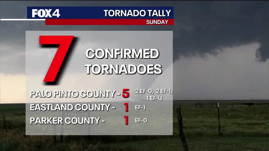
The National Weather Service confirmed an EF-1 tornado in the city of Gordon with estimated peak winds of 105 miles per hour.
Another EF-1 tornado was located in Mingus.
Four EF-0 tornadoes were confirmed on Sunday. One near Morton Valley in Eastland County, another in Santo, a third just south of Santo and a fourth in Parker County.
An EF-U tornado was detected southeast of Santo. EF-U stands for EF-Unknown, meaning the tornado's intensity could not be determined due to the lack of visible damage.
Enhanced Fujita Scale
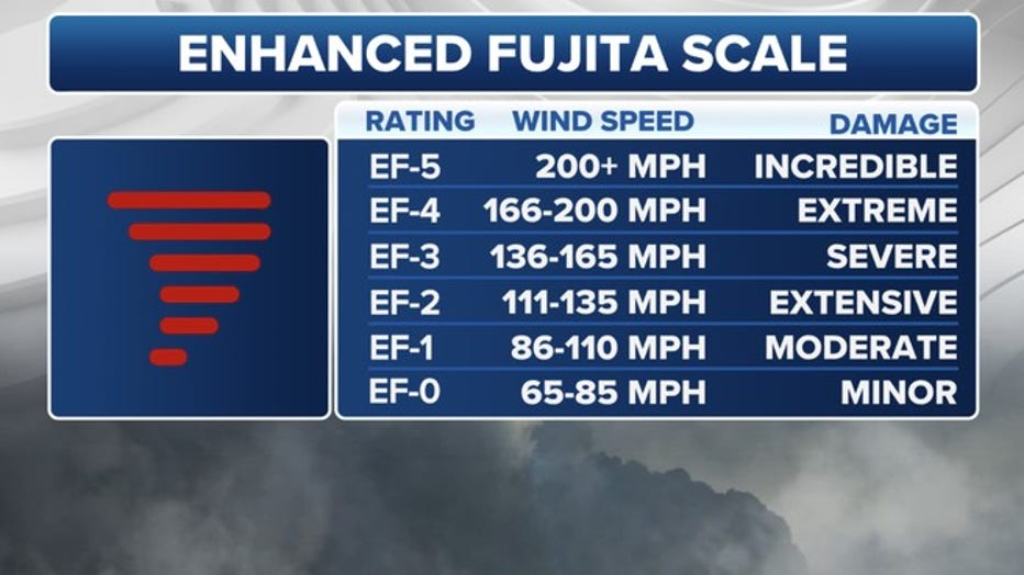
Source: FOX Weather
A tornado is assigned a rating on the Enhanced Fujita Scale to estimate its intensity.
Palo Pinto County Storm Damage

Severe weather moves through North Texas
On Sunday evening, severe weather moved through North Texas, triggering tornado and severe thunderstorm warnings. The National Weather Service has already confirmed a tornado in Palo Pinto County. FOX 4's Payton May has a look at some of the hardest hit areas.
Some of the hardest hit areas were about 65 miles west of Fort Worth in Palo Pinto County. The National Weather Service has confirmed a tornado touchdown.
So far, Gordon ISD and Santo ISD are closed today due to damage in the area.

North Texas storm damage from SKY 4
See the damage left behind in Palo Pinto County after tornado-warned storms moved through on Sunday night.
Gordon ISD announced on Monday that it would closed for the rest of the week.
There is heavy damage and debris around the football field and track. There are several destroyed buildings and light poles down.
Palo Pinto County's Emergency Management coordinator says 36 buildings in Gordon were damaged. Five of the damaged buildings are considered major, with one destroyed.
There is a power outage in the area, but crews are on the scene trying to restore the power. More than 1,200 customers are without power in that area.
Gordon ISD is asking students and staff to stay away for their safety.
Santo ISD also announced closure due to storm damage. Neither district has said when they'll reopen.
FOX 4 viewer Keisha Carlson caught two funnel clouds forming next to each other in Santo, but they don't appear to touch down.

Santo funnel clouds
Video from Jeremy and Marisol Lewis shows two funnel clouds in Santo, Texas on Sunday, May 18.
North Texas Storms
FOX 4 viewers have sent in photos of storms as they move into the area.
Baseball sized hail was reported in some areas.

Dallas weather: Severe weather risks for Monday
Scattered showers and potentially severe storms are possible today, especially north of the Metroplex, with risks of hail, wind, and even a tornado this afternoon and evening.
There was also storm damage reported north of Dallas and Fort Worth, in Flower Mound. Marian Orchard reported power lines down in a backyard that caused a fire.
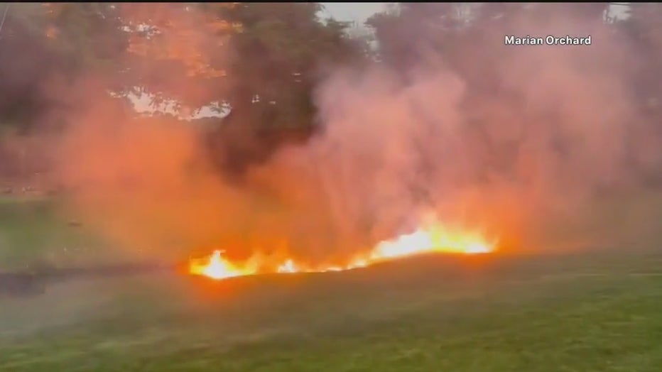
Flower Mound. Power lines down in a backyard causes fire (Source: Marian Orchard)
The Source: Information in this article is from FOX 4 coverage, The National Weather Service, and FOX 4 Viewers.