

Dallas weather: Heavy rain and cooler temperatures

Dallas weather: Forecast for June 9
Showers will dry up this morning, and it will be less hot, but still humid. FOX 4 Meteorologist Evan Andrews has your forecast.
DALLAS - North Texas can expect a reprieve from the early summer heat this week, with cooler temperatures and significant rainfall anticipated, which could lead to localized flooding.
Workweek Forecast
Big picture view:
The workweek began with the departure of morning showers, giving way to partly sunny skies and high temperatures in the mid- to upper 80s on a light north wind, according to weather forecasts. An exception may be for areas southwest of Fort Worth, where a lingering band of moisture could produce isolated showers.
A separate weather disturbance is expected to develop in West Texas overnight and approach the Dallas-Fort Worth area before sunrise Tuesday. The system will contend with drier air, making rainfall chances higher for western and southern counties, while northern and eastern areas are less likely to see precipitation. Increased cloud cover will keep temperatures below the early June average of the low 90s.
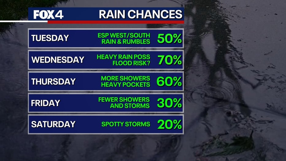
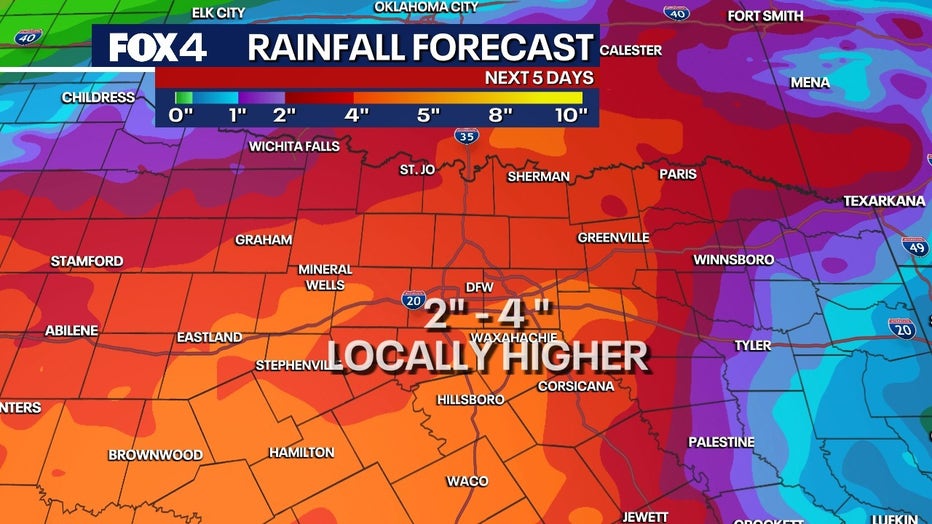
We anticipate a wetter period mid-week as a slow-moving upper-level system settles over Texas for at least two days. This system will increase the chances for more widespread showers and thunderstorms from Wednesday into Thursday.
While the risk for severe storms is considered low, the potential for heavy rainfall is high. With June humidity in place, daily rainfall totals could exceed one to two inches, with some locations receiving heavier amounts. This could lead to flooding in some areas.
By the end of the week, the weather system is expected to begin moving away, though its speed is uncertain. Lingering showers and thunderstorms will remain possible, but they are expected to be less widespread than in the preceding days.
7-Day Forecast

The drying trend is forecast to continue into the weekend, which will also mean a return to more typical mid-June temperatures in the low 90s, accompanied by high humidity.
The Source: Information in this article is from the FOX 4 weather team.