

DFW Weather: National Weather Service confirms 5 tornadoes from Tuesday's storms
DALLAS - The National Weather Service has confirmed five tornadoes so far that touched down in North Texas during Tuesday's severe storms.
1 tornado confirmed in Parker County

Mineral Wells EF-3 tornado
A survey team with the National Weather Service in Fort Worth has confirmed that around 5 p.m. along Highway 180, an EF-3 tornado with winds up to 145 mph formed in Mineral Wells Tuesday evening.
The NWS said the rating is preliminary and could change as they finalize their investigation.
Mineral Wells working to clear tornado damage
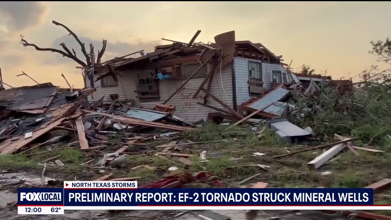
Emergency crews in Mineral Wells gave an update on Wednesday on the impact of Tuesday night's severe weather. A preliminary report suggests an EF-2 tornado hit the city, causing heavy damage to homes and businesses.
Officials are still asking people to avoid the area because they said it’s not safe, and the city is still working to determine when displaced residents will be able to return.
The industrial region of Mineral Wells was badly hit, with entire warehouses leveled. Other homes and buildings suffered significant damage with roofs ripped off and debris scattered everywhere.
There were no fatalities reported, but authorities said several people were taken to the hospital.
3 tornadoes confirmed in Johnson County

Two tornadoes formed from a cell that began near Cleburne and ended near Rio Vista, and a third tornado formed near Cresson.
Cleburne EF-0 tornado
An EF-0 tornado with maximum winds of 80 miles per hour formed west of Cleburne in Byron Stewart Park on Tuesday evening.
The tornado crossed onto Lake Pat Cleburne and exited the lake to the southeast, forming a path of 3.5 miles in length and 150 yards in width.
Damage reported included trees being destroyed and a small porch and doors at an RV storage garage.
Rio Vista EF-1 tornado
The same storm that produced the Cleburne tornado also produced an EF-1 tornado that hit Rio Vista with winds peaking at 90 miles per hour.
The tornado's path was 2 miles long and 100 yards wide.
The tornado formed to the northeast of Rio Vista near Hill Court before moving southeast, crossing FM 916 and dissipating near County Road 1204 and 1104.
Damage included trees, roofs of homes and businesses, and lightweight metal objects in the tornado's path. Thankfully, no major injuries were reported in the county.
Baseball-sized hail was reported from storms produced near Godley.

Cresson tornado
The National Weather Service confirmed a tornado briefly formed on the east side of Cresson Tuesday evening.
Survey crews could not determine a damage path, and the NWS says more investigation is needed. It has been assigned an N/A rating as the investigation continues.
1 tornado confirmed in Montague County
The NWS says video evidence confirmed a brief tornado developed east of Highway 59 near the Montague Co. and Clay Co. line.
Tree damage can be seen in the video, but the NWS does not have additional information on the tornado at this time.
Storm investigation continues
What's next:
The National Weather Service is still investigating Tuesday's storms, meaning the tornado ratings could change by the time their investigation is finished.
The Source: Information in this story comes from the National Weather Service and FOX 4 reporting.