

Dallas weather: Temps set record high on Saturday, cold front coming

Dallas weather: Feb. 8 morning forecast
FOX 4 meteorologist Kylie Capps takes a look at the weather across the region and the cooldown that is on the way.
DALLAS - North Texas saw record-breaking heat on Saturday before a cold front drops temperatures for next week.
New record temperature
The record for the highest temperature on February 8 fell on Saturday.
DFW Airport record a high of 86 degrees, breaking the old record of 85 degrees in 1962.
Saturday Forecast
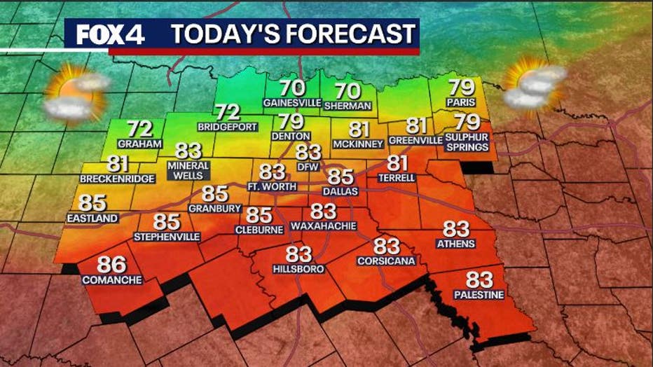
What we know:
Saturday starts warm with humid air and some low clouds.
We will get more sun as southwest breezes push temperatures up into the 80s shortly after noon in many areas.
A cold front will be moving south this afternoon, and is expected to cross the Metroplex between 2 p.m. and 3 p.m.
You will feel gusty winds and temperatures will fall quickly.
By sunset, we will be back in the 50s.
There is also a 10% chance for a small shower.
Sunday Forecast: Cold, Overcast Day
What we know:
The chilly air will filter in overnight and we will wake up on Sunday morning with temperatures in the 40s.
There will be cloudy skies and the possibility of patchy mist.
It will be overcast and chilly.
The main point is that it will barely warm at all with most of the area staying in the 40s.
A good day for staying in and watching the Super Bowl on FOX 4 or Tubi!
What we don't know:
There could be patchy spots of light rain or mist, but even if there is precipitation, it will be nothing major.
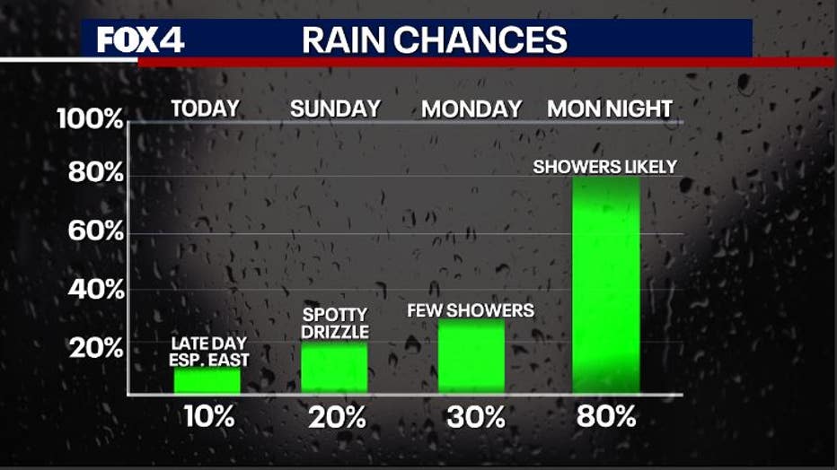
7-Day Forecast: Chilly and Wet

Timeline:
The next week will be chilly and wet. We'll have a very active southern branch of the jet stream racing overhead while cold air filters into the US.
None of it is expected to be brutally cold, but we won't be likely to see much sun.
We don't see freezing temperatures through Wednesday when we will be seeing rain, but it won't be much warmer than that.
- Monday: Cloudy skies and temps in the 40s all day with some patchy light rain.
- Tuesday: 80-90% coverage of cold rain with a few rumbles. We will generally be in the 40s with rain ending in the afternoon.
- Wednesday: A late disturbance will kick up rain late Tuesday night into Wednesday morning. Temperatures may start in the upper 30s and finish in the 40s as the rain ends.
- Thursday: Dry, but colder as north winds blow. We could start at freezing or below in the morning and finish in the low 40s.
- Friday: Valentine's Day will be a touch milder in the 50s after a freezing start as winds return to the south.
The Source: Information in this article comes from the FOX 4 weather team.