

Dallas weather: Unsettled week ahead with rain, severe storm threat
Everman hail: Seven Hernandez
DALLAS - North Texas officially enters "meteorological summer" Monday, which is expected to bring increased storm activity and a potential flood risk to the area throughout the week.
Monday Forecast

Dallas weather: June 2 morning forecast
Low storm chances for North Texans today, but don't get too comfortable... Severe storms are possible later this week. Meteorologist Ali Turiano has your forecast.
What we know:
Showers and storms are moving south from Oklahoma this morning, driven by an upper-level disturbance. While not all areas will see rain, scattered showers are possible in areas north and east of DFW through noon. These initial storms may contain small hail and gusty winds but are not expected to be severe.
As the disturbance moves south of the Metroplex (south of Interstate 20) this afternoon, temperatures will rise into the 80s with increasing humidity. This could trigger a couple more isolated storms capable of hail and wind gusts exceeding 50 mph. Monday night is expected to see the return of more typical early June weather.
Hail damaged cars and homes in Tarrant County on Sunday

Tarrant County residents dealing with hail, storm damage
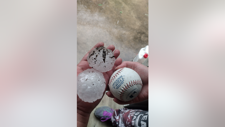
Some cities in Tarrant County saw quite a bit of damage from Sunday's storms. Some of the hail that fell was the size of baseballs.
Local perspective:
Some Everman residents saw baseball-size hail on Sunday.
"It was scary, it was very loud. And I'm like what, what is going on," said Keitha Titus, Everman resident. "But thankfully, thank the Lord, that, that's all that happened. It could have been worse."
Tuesday Forecast
What's next:
Tuesday morning will likely bring low clouds and warmer temperatures, with a chance of an isolated shower. Temperatures are forecast to reach the low 90s under a mix of clouds and sun.
Beginning Tuesday, several disturbances are expected to lead to rounds of possible heavy rain and an elevated flood risk. There will also be a threat for severe weather, primarily high winds, and a lower tornado risk later in the week as a front moves into the area. Storms are expected to develop late Tuesday afternoon into the evening, bringing a severe risk and flood threat. These storms should diminish overnight.
7-Day Forecast

Wednesday is expected to be mostly quiet, but renewed stormy activity is possible late Wednesday into Thursday morning with more rain and storms, including some severe weather and a continued flood risk.
This unsettled pattern, with the potential for heavy rain and severe weather, is expected to continue through Friday and into the weekend.
The Source: Information in this article comes from meteorologist Evan Andrews and the National Weather Service.