

Tropical Storm Gonzalo on track to become 1st Atlantic hurricane of 2020 as Douglas strengthens in Pacific

LOS ANGELES - The fourth named storm and first official hurricane of the eastern Pacific season formed on Wednesday, and Hurricane Douglas is intensifying as it moves toward Hawaii. Meanwhile, Tropical Storm Gonzalo continues to strengthen in the Atlantic Ocean and is on track to become the first hurricane of the 2020 Atlantic hurricane season.
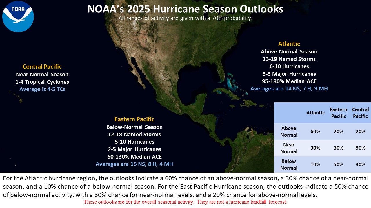
The National Oceanic Atmospheric Administration’s Climate Prediction Center forecasted an above-average Atlantic Hurricane Season in its 2020 May outlook for the season. “That is exactly what has been taking place,” Dennis Feltgen, a meteorologist with NOAA and the National Hurricane Center, said.
The Atlantic hurricane season runs from June through November, and the first two months of the season are typically quite slow. But 2020 has proven to be active in the Atlantic, as seven named storms have already formed.
In contrast, NOAA’s 2020 eastern Pacific Hurricane Season Outlook indicates a near or below-normal season most likely.
Douglas expected to impact Hawaiian Islands
Douglas strengthened into a hurricane Wednesday morning, and is forecast to approach Hawaii this weekend as a hurricane or tropical storm.
On Thursday, Douglas was centered about 1,000 miles east-southeast of Hilo, Hawaii in the eastern north Pacific, according to the NOAA’s National Hurricane Center.
Douglas has continued to intensify and was a major, category 3 hurricane with maximum sustained winds of 120 mph, as of Thursday morning. The storm was moving west-northwestward at 20 mph.
RELATED: National Weather Service proposes new wireless alerts for most intense thunderstorms
The current model track suggests the storm would approach Hawaii Saturday and potentially impact the Hawaiian Islands, particularly east-facing coasts, by the weekend into early next week.
“There is an increasing chance that strong winds and heavy rainfall could affect portions of the state beginning on Sunday,” Feltgen said. This system may also produce flash flooding.
The system will likely weaken by the time it reaches Hawaii as it encounters cooler water. How much it weakens is yet to be determined. There were no coastal watches or warnings in effect on Thursday.
Tropical Storm Gonzalo strengthens in Atlantic
Meanwhile, Tropical Storm Gonzalo was strengthening in the Atlantic and may become the first hurricane of the 2020 Atlantic hurricane season by Thursday evening.
This system formed in the Atlantic Ocean between Africa and the Lesser Antilles and could bring direct impact, including heavy rainfall and winds, to parts of the southern Windward Islands this weekend.
The southern Windward Islands should be prepared for strong winds and heavy rainfall.
Gonzalo was located several hundred miles east of the southern Windward Islands on Thursday, with sustained winds of 60 mph.
As of Thursday, the system was heading west at 14 mph. Expect a west-northwest track into the Windward Islands by Saturday, followed by the eastern Caribbean Sea by Sunday.
But Gonzalo poses forecast challenges regarding its intensity.
“The intensity forecast remains very problematic and of low confidence. On one side, the cyclone has been strengthening quickly and the good organization suggests additional, and possibly rapid, strengthening should occur,” Feltgen said.
Dry air entertainment currently north and west of Gonzalo could weaken the storm’s development. Certain models, including the GFS, UKMET, ECMWF, and Canadian models forecast the system to be weak or dissipate.
On the flip side, warmer-than-average ocean temperatures may continue to help fuel the storm. Looking at models, “the SHIPS-based guidance and the HWRF make the system a hurricane and keep that intensity,” Feltgen said.
RELATED: Dazzling comet will make closest approach to Earth in July — here’s how to watch
Gonzalo became the earliest seventh named tropical storm on record to form in the Atlantic basin.
Feltgen said it is too soon to determine the magnitude and exact timing of its impacts, and whether Gonzalo will have any impact on the U.S. mainland, but the storm should continue to be monitored.
A tropical depression brings showers to South
On Wednesday, satellite wind data indicated that a broad low-pressure area had formed in association with a tropical wave over the central Gulf of Mexico.
This tropical wave has now been upgraded to a tropical depression and is expected to become a tropical storm. If the system becomes a tropical storm, it would be an “H” storm, named Tropical Storm Hanna.
The system is producing large, but poorly organized showers in the Gulf of Mexico. The storm will track across the Gulf of Mexico, to the west, and is expected to move inland over Texas by late Friday or Saturday.
Conditions appear conducive, and intensification is possible as it moves west at about 7 mph.
A tropical storm watch has been issued for most coasts of Texas. Main threats include locally heavy rain, gusty winds, high surf, and flash flooding for Texas and Louisiana coasts. Some localized areas could see up to eight inches of rain.
The Climate Prediction Center will update its hurricane outlook on Aug. 6, just ahead of the peak of hurricane season, which typically occurs between mid-August through late October.