

Dallas weather: Severe thunderstorm, flash flood warnings issued as heavy rain pounds North Texas
Dallas weather: May 24 overnight forecast
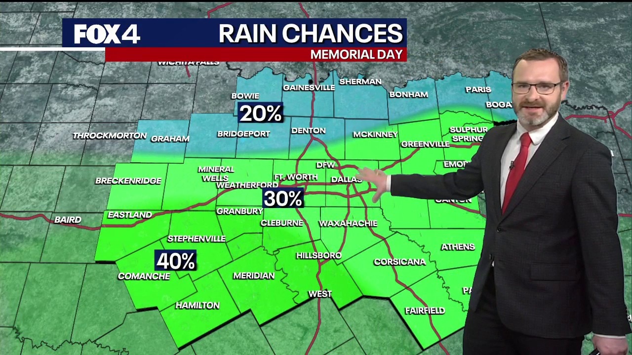
FOX 4's Josh Johns breaks down the rain chances in North Texas for Memorial Day and what to expect in the week going forward.
DALLAS - Severe thunderstorm and flash flood warnings remained in effect Sunday night for parts of western North Texas as slow-moving storms continued producing heavy rain, hail and gusty winds across the region.
Severe weather warnings

What we know:
The National Weather Service issued a flash flood warning Sunday night for Hamilton County through 11:30 p.m. after radar estimated 2 to 3 inches of rain had fallen in a short amount of time near Hico and surrounding areas.
Forecasters warned flash flooding could begin quickly and urged drivers not to cross flooded roads.
A severe thunderstorm warning also remained in effect for Erath and Hamilton counties through 10:15 p.m. as a strong storm near Hico continued moving slowly across the area.
Meteorologists said the storm was capable of producing wind gusts up to 60 mph and hail up to the size of quarters.
Flash flood warnings also remained in effect for parts of Dallas and Tarrant counties because of heavy rainfall earlier in the day that left some roads flooded or hazardous for drivers.
FOX 4 meteorologists said the heaviest rain Sunday night remained concentrated south and west of the Metroplex, where scattered downpours continued drifting through areas near Eastland, Stephenville, Granbury, Hico and surrounding communities.
What they're saying:
FOX 4 meteorologists said the storms were not expected to produce tornadoes because atmospheric conditions were not favorable for rotation.
"This is not an environment that’s conducive to tornadoes," FOX 4 meteorologists said during live coverage Sunday evening. "These storms can pulse up real quick and then pulse back down."
Meteorologists described the activity as typical summer "pulse thunderstorms" capable of producing brief periods of heavy rain, frequent lightning, gusty winds and small hail before weakening quickly.
Josh Johns posted on X shortly after 9:30 p.m. that flash flood warnings had been issued for Hamilton County after several inches of rain fell in a short period of time.
"DO NOT CROSS FLOODED ROADS," said Johns.
Earlier Sunday night, Johns warned the slow-moving storm near Hico could quickly produce strong downburst winds and quarter-size hail.
Memorial Day Weekend Storm Forecast

Dig deeper:
Heavy rain and lightning continued Sunday night in parts of Parker, Erath, Hamilton and Hill counties, including areas near Weatherford, Stephenville, Hico, Hillsboro and Itasca. Moderate to heavy rain also lingered in portions of Fort Worth, including White Settlement, River Oaks and downtown.
Radar showed the strongest storms remained mainly west and southwest of the Metroplex late Sunday evening, with activity becoming increasingly scattered rather than organizing into large storm clusters.
Forecasters said earlier rainfall across parts of North Texas helped stabilize the atmosphere in some areas, limiting additional storm development closer to Dallas and Fort Worth.
The primary threats from the storm remained heavy rainfall, frequent lightning, small hail, isolated damaging wind gusts and localized flash flooding.
When will widespread rain and storms hit?
What's next:
Forecasters expect storm activity to gradually weaken later Sunday night as daytime heating fades after sunset, though isolated showers and storms could linger overnight south and west of the Metroplex.
Scattered showers and thunderstorms remain possible through Memorial Day, though widespread severe weather is not expected. Rain chances are forecast to continue into Tuesday before a stronger weather disturbance arrives Tuesday night into Wednesday, bringing the best chance for more widespread showers and thunderstorms during the upcoming week.
Drier weather and warmer temperatures in the upper 80s are expected to return by late next week.
The Source: Information in this article was provided by the FOX 4 Weather Team.