

Tropical Storm Edouard brings rain and heat relief to some parts of Texas
Dallas weather: Sept. 1 morning forecast
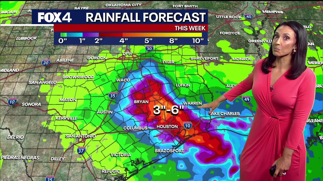
Tropical Storm Edouard heads NW making a Texas landfall later today. This storm quickly weakens and heads northward, returning rain chances to North Texas for the next several days. Highest coverage of rain is expected to be south and east of the Metroplex.
DALLAS - North Texas is bracing for relief from a monthlong heatwave and severe drought as Tropical Storm Edouard moves toward the Texas-Louisiana border, bringing cooler temperatures and desperately needed rain to parts of the region while introducing new challenges for local firefighters.
The incoming storm follows a brutal August marked by near-record dry conditions and extreme heat. Most of the region has gone 47 days without measurable rainfall, making it the tied second-driest August on record. Prior to the storm's arrival, area residents endured 11 consecutive days of triple-digit temperatures, capping off a month that saw 27 days of 100-plus-degree heat.
Rainfall Almanac
It's been rough for the entire month of August, just broiling basically and dry. Temperatures have already reached 83 degrees in Dallas and the low 80s in Fort Worth during the early morning hours.

Tropical Storm Edouard
Tropical Storm Edouard, currently carrying sustained winds of 40 mph with potential intensification up to 65 mph before landfall, is projected to move west-northwest before weakening as it approaches Central Texas.

Tropical Storm Edouard Live Tracker: Latest path, wind speeds, Texas impacts
Track Tropical Storm Edouard in real time with our live updating map, current wind speeds, central pressure, distance from land and official National Hurricane Center watches and warning for Texas.
While the system is expected to lose its tropical status by Wednesday afternoon, it will push a weak low-pressure area, increased cloud cover, and higher humidity into North Texas.
The shift in weather offers a mixed outlook for emergency crews battling regional wildfires. While higher humidity levels and elevated moisture will aid firefighting efforts over the next several days, forecast wind gusts out of the east-southeast reaching up to 20 mph Wednesday could threaten containment lines.
Where will it rain in Texas?
Rainfall distribution across the state will vary significantly:
- Southeast Texas: Heavy rain totals of 3 to 6 inches are forecast for the Houston and Bryan areas, with isolated spots seeing up to 9 inches.
- South and East of Dallas-Fort Worth: Areas such as Mexia and Fairfield could receive up to 3 inches of rain.
- Dallas-Fort Worth Metroplex: Rainfall is expected to remain generally under 1 inch.
- Northwest of DFW: Rain totals drop off significantly, with many areas expected to receive only a trace or remain entirely dry due to how rapidly the system is weakening.
Texas Radar

The arrival of the storm system will break the consecutive streak of 100-degree days, pulling high temperatures back into the 90s for Wednesday and Thursday alongside noticeable humidity. Scattered showers and brief, isolated thunderstorms with occasional lightning are expected to begin popping up Tuesday evening and increase through mid-week.
The reprieve, however, will be short-lived. Forecast models indicate the moisture will clear out just in time for the upcoming holiday weekend, bringing a return to dry conditions and warming temperatures across North Texas.
7-Day Forecast

The Source: Information in this article is from the FOX 4 weather team.