

DFW Weather: FOX 4 viewers document severe weather, storm damage across North Texas
Severe storms, hail and possible tornado slam North Texas
North Texas was pummeled by severe weather on Tuesday, with buildings in Mineral Wells getting destroyed by a possible tornado, houses in Johnson County experiencing baseball-sized hail, and many other counties experiencing damage and power outages. FOX 4's Dan Henry, Amelia Jones and Peyton Yager recap the evening of storms.
DALLAS - FOX 4 viewers helped us document Tuesday's severe weather with pictures and videos of strong thunderstorms, intense hail and damage from a possible tornado in Mineral Wells.
Send us your photos & videos
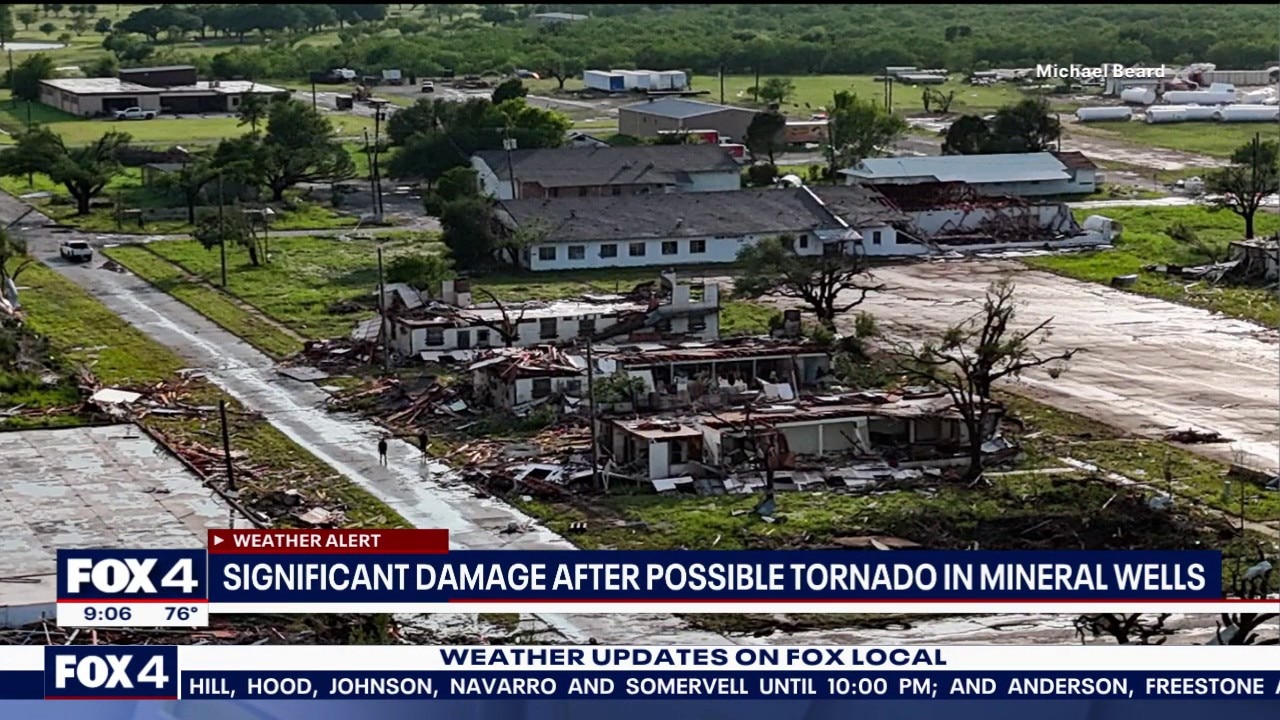
North Texas storm damage
Parker County damage
We've been sent images and video of damage from the severe storms in Mineral Wells. The Butler Ventamatic building near 100 Washington Road has been destroyed.

Mineral Wells damage (Courtesy: Ashley Renae Valdez)
Video of the Parker Hannafin Facility in Mineral Wells shows it was heavily damaged by today's storms.
Katelyn Mott sent in pictures of damage to Country Club Estates off of Country Club Road in Mineral Wells.
An RV park in Mineral Wells also suffered severe damage.
More significant damage was reported in Mineral Wells, where the second story of several houses appears to have been torn clean off.

Homes in Cresson encountered heavy hail storms Tuesday evening.
FOX 4's Peyton Yager saw homes in Cresson that had broken windows and heavy damage from hail that impacted the area.
Wise County damage
Baseball-sized hail has been reported in Godley.
Montague County damage
Savannah Rae Stephens sent in this image of a playhouse in Bowie that was destroyed by today's severe weather.

CTSY: Savannah Rae Stephens
FOX 4 viewer James Tyler Burch shared this video of a funnel cloud forming near Highway 59 in Bowie.
Wise County damage
The Lake Bridgeport Fire Department reported damage to their garage and trees near their station.
Viewers in Wise County sent in pictures of hail that rained down in Bridgeport and Paradise.
North Texas storms
Robert Adcox sent us this image of the storms from high above as his plane took off from DFW Airport.

CTSY: Robert Adcox
Treavor in Springton sent in this picture of a shelf cloud created by today's storms.

Tuesday Forecast
The National Weather Service has issued a Tornado Watch until 9 p.m. for Hood County, Denton County, Dallas County, Hopkins County, Fannin County, Collin County, Kaufman County, Erath County, Rains County, Somervell County, Rockwall County, Parker County, Lamar County, Ellis County, Tarrant County, Van Zandt County, Johnson County, Jack County, Delta County, Cooke County, Wise County, Palo Pinto County, Hunt County.

A cold front moving into the region will keep storm chances high. A morning disturbance is bringing showers and storms primarily near the Red River, with more scattered activity expected this afternoon and evening as the front approaches.
Some storms are likely to become severe, capable of producing damaging winds and very large hail. While the tornado threat remains low, an isolated touchdown cannot be ruled out. Afternoon highs will reach the mid-80s before conditions quiet down overnight.

The upgrade to a Level 4 Moderate risk does NOT mean that storms are expected to be worse than we've been discussing. However, it does mean that the threat for very large hail is highlighted a little more.
According to the FOX 4 Weather team, the timeline has not changed. People should stay weather aware beginning in the early afternoon as storms redevelop to the north and then around the rush hour for the Metroplex.
The Source: Information in this story comes from FOX 4 viewers.