As Harvey finally fizzles, a look at what made it so nasty

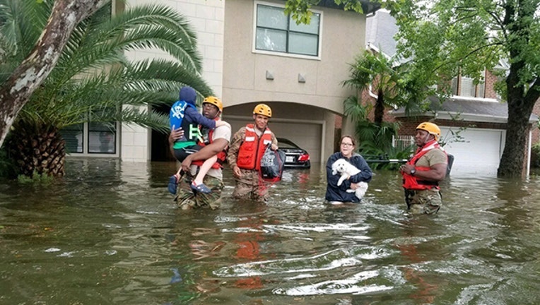
U.S. Soldiers assigned to the Texas Army National Guard arrive in Houston to aid citizens in areas heavily flooded by the storms of Hurricane Harvey Aug. 27, 2017. (U.S. Army National Guard photo by 1st Lt. Zachary West)
WASHINGTON (AP) - The slow-moving, super-wet and especially devastating storm named Harvey is finally fizzling.
Since first hitting shore near Corpus Christi, Texas, more than a week ago, the storm dumped 27 trillion gallons of rain on Texas and Louisiana - enough to cover all of Manhattan a mile (1.6 kilometers) deep. It set a record for rainfall from a tropical system in the continental U.S., dropping 51.88 inches (1.3 meters) just outside Houston. That's only an eighth of an inch (3.2 millimeters) behind the U.S. record set in Hawaii in 1950.
The deluge damaged an estimated 156,000 dwellings, and parts of Houston may be flooded for another month. The death toll of 44 ranks it as the mainland's sixth deadliest hurricane in 50 years.
What made it so bad? Harvey was strange - in how it nearly dissolved once but roared back as a major hurricane, in how it intensified so quickly before hitting land, in how it parked itself over one unfortunate region for so long and, of course, in the amount of rain it generated.
"It had several unique characteristics in terms of its strength and track. And unfortunately they combined to produce a severe impact over a highly populated area," National Hurricane Center Acting Director Ed Rappaport said.
Harvey was born in the Atlantic southeast of Puerto Rico on Aug. 17, then got downgraded to a tropical wave and breezed into Mexico's Yucatan peninsula with little fanfare. But once Harvey got into the Gulf of Mexico on Aug. 23, it rapidly exploded into a Category 4 hurricane just a few hours before coming ashore, something experts had not seen happen much before.
It was the first Category 4 storm to make landfall in the United States since 2004. Rappaport and others said it will likely rank among the costliest storms to hit the United States. In some ways, it landed in the perfect place to wreak the most havoc. The worst of its rains stayed to the east of its eye and hit very close to the nation's fourth-largest city, a city that is as flat as a tabletop and especially prone to flooding.
That's what Harvey will be remembered for, even though coastal cities like Rockport were all but flattened, said University of Miami senior hurricane researcher Brian McNoldy. "They're going to take backstage to Houston."
Most hurricanes, including 2005's Katrina, weaken just before they hit shore. Harvey got much stronger, fueled in part by pockets of extra warm water in the Gulf of Mexico.
"Harvey was the first to go from tropical storm strength to major hurricane strength in its last 36 hours before U.S. landfall," Rappaport said.
Then it just stuck around.
For more than 130 hours - from 10 a.m. Friday, Aug. 25, through 10 p.m. Wednesday, Aug. 30 - Harvey was raining over some part of eastern Texas. When Harvey did move, including a dip back into the Gulf of Mexico for about a day, it was still close enough to drench Texas.
"It's extremely rare to have a major hurricane that just sits there after it makes landfall," McNoldy said.
Usually strong storms blast through an area, dump a foot or so of rain, and move on. But Harvey was stuck between two high pressure weather systems to the east and west that kept pushing it in opposite directions, so it just staggered in a zig-zag pattern across southeast Texas.
"The sheer area that was inundated by 20 inches (51 centimeters) of rain was unbelievable," said Jeff Masters, meteorology director of the private forecasting service Weather Underground.
If it had only continued a bit farther, over northern Texas, Harvey would not have been as wet. But by stalling near the coast, the storm was allowed to draw more and more moisture from the gulf and sustain extraordinary rainfall rates, including more than 4 inches (10 centimeters) per hour over the Beaumont-Port Arthur area, Masters said.
Finally, after its second U.S. landfall along the Texas-Louisiana border, Harvey started to move on.
It pushed north and east, weakening but still dumping several inches of rain on Mississippi, Alabama, Tennessee, Kentucky, Indiana and North Carolina. By Sunday, forecasters say, the storm's remnants will look like regular weather.
Meteorologists are already eyeing another system: Hurricane Irma, which intensified from a tropical storm to a major hurricane in just 30 hours, is steadily moving west across the Atlantic. It's still several days away from the nearest land just south of Puerto Rico.

