

Dallas weather: Rain, potentially strong to severe storms on Wednesday
It has been a while, but rain and cooler weather are expected to come to North Texas.
Wednesday is when the big changes will start taking place.
A Severe Thunderstorm Watch is in place until 2 a.m. for the majority of our viewing area.
The National Weather Service expanded the area under an enhanced risk of severe weather on Wednesday afternoon. An enhanced risk is a 3 out of 5 on the NWS scale.
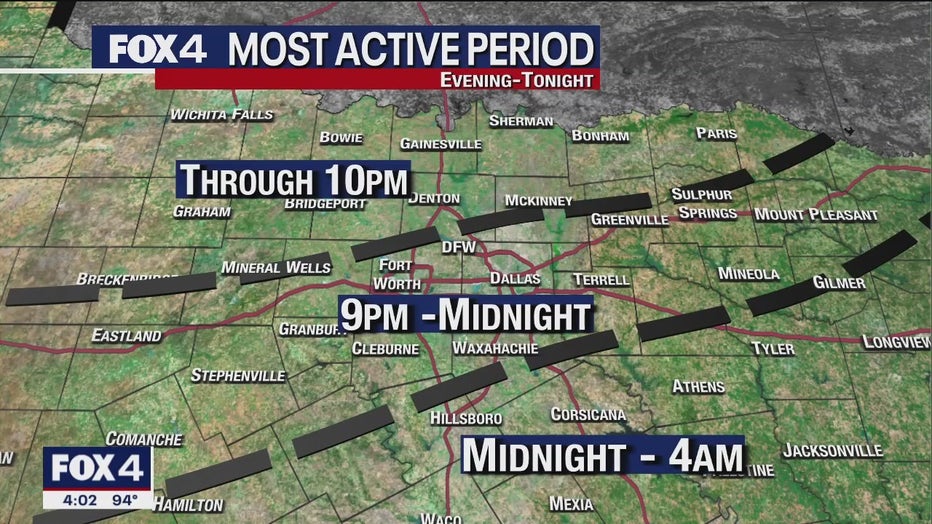
We will see a line of heavy rain and potentially strong storms move through the area Wednesday night into the early morning hours on Thursday.
The rain came in from the northwest around 7 p.m.
It moved into the DFW area at 9 p.m. and will stick around through midnight.
A cold front brings the chance for severe storms with it.
There is a slight risk of severe weather for much of North Texas, especially in the DFW-area and to the north and west.
We expect the storms to weaken as they move east and southeast.

The heavy rain is going to be the biggest threat for everyone.
There is about a 90% chance of heavy rain, flooding and severe wind gusts. The chance for up to golf ball-sized hail is lower, but not zero.
There is a minute possibility that a tornado could pop up. That threat is generally north and northwest of the Metroplex.
Again, late Wednesday night into Thursday morning will be when we see the widespread, heavy rain.
After the rain comes through drier air will stick around.
Temperatures will be near normal on Friday before a shot of cooler air over the weekend.
We will have a nice taste of fall this weekend with low temperatures in the 50s and highs in the 70s on Saturday and Sunday.